البرز
| البرز | |
|---|---|
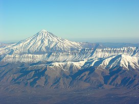
 نمای هوایی از کوه دماوند | |
| مرتفعترین نقطه | |
| ارتفاع | ۵٬۶۱۰ متر (۱۸٬۴۱۰ فوت) |
| فهرستبندی | |
| ابعاد | |
| طول | ۶۰۰ کیلومتر (۳۷۰ مایل) |
| عرض | ۱۳۰ کیلومتر (۸۱ مایل) |
| مساحت | ۱۵۵٬۹۷۰ کیلومتر مربع (۶۰٬۲۲۰ مایل مربع) |
| جغرافیا | |
| مختصات رشتهکوه | ۳۵°۵۷′۲۰″ شمالی ۵۲°۰۶′۳۶″ شرقی / ۳۵٫۹۵۵۵۶°شمالی ۵۲٫۱۱۰۰۰°شرقی |
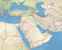
البرز رشته کوهی در بخش شمالی ایران است. ریشهٔ نام آن در زبان اوستایی هره بره زئیتی و در زبان پهلوی هره بُرز است و ریشه نام البرز در زبان پارسی میانه هَرْبورْزْ میباشد.[۱] این رشته کوه از سوی باختر از جمهوری آذربایجان آغاز میشود و در سوی شرق تا درون ترکمنستان و افغانستان دنباله مییابد. بخش بزرگی از البرز در راستای کنارهٔ جنوبی دریای خزر[۲] کشیده شدهاست. در این بخش، جبههٔ شمالی البرز سرسبز و جبههٔ جنوبی آن خشک است. یک دلیل این دوگانگی وجود رشته کوه البرز است که همچون سدّی طبیعی از گذر رطوبتِ برخاسته از دریای خزر به سوی جنوب جلوگیری میکند و بیشتر این رطوبت در جبههٔ شمالی البرز میبارد.
بلندترین کوه البرز و ایران، کوه دماوند (۵۶۱۰ متر) است که در استان مازندران، شهرستان آمل، در منطقه لاریجان قرار دارد. دامنهها و درههای البرز از تفرجگاههای مهم مردم استانهای مازندران، تهران، زنجان، البرز، گیلان، اردبیلقزوین، سمنان و گلستان است. از مهمترین رودهای دامنهٔ شمالی البرز سفیدرود و دامنههای جنوبی کرج و جاجرود را میتوان نام برد. قلههای بسیاری برای کوهنوردی در این رشته کوه وجود دارند که میتوان از میان آنها دماوند، علمکوه، سماموس، خلنو، آزادکوه، شاهالبرز، سیالان، وروشت، دوبرار، توچال و پهنهحصار را نام برد.
ویژگیهای زمینشناسی و جغرافیایی[ویرایش]

از دید چینهشناسی و زمینساخت (تکتونیک)، رشته کوه البرز به سه بخش خاوری (شرقی)، مرکزی و باختری (غربی) بخشبندی میشود. البرز باختری از رودخانه آستاراچای تا دره سپیدرود، البرز مرکزی از دره سپیدرود تا دره فیروزکوه و رود تالار، و البرز خاوری از دره فیروزکوه تا گرگانرود و مرز خراسان کشیده شدهاست. البرز باختری بخش مهمی از کوههای تالش را در برمیگیرد. این کوهها از گردنه حیران تا غرب شهرستان هشتپر کمابیش به خط راست به سمت جنوب سپس به سوی جنوبشرقی امتداد یافته و در جنوب شهرستان رشت به دره سپیدرود میپیوندد.[۳]
در دامنههای شمالی این نوار کوهستانی، چشمانداز طبیعی ویژهای شکل گرفتهاست که از لحاظ حجم و تراکم پوشش گیاهی و درجه حاصلخیزی در ایران منحصر به فرد بهشمار میآید. در دامنه شمالی البرز و در ارتفاع حدود ۲۵۰۰ متری از سطح دریا، جنگلهای خزاندار کوهستانی آغاز میگردد که با چهرهای متنوع همراه با انواع گونههای درختی تا جنگلهای انبوه و بعضاً غیرقابل نفوذ دشتهای پست خزر جنوبی امتداد مییابد.[۴]
تاریخ زمینشناسی سلسله البرز به نوبه خود بسیار پیچیدهاست؛ به کرات در حین چینخوردگیها یا بعد از آن پدیدههای آتشفشانی ظاهر شدهاند. مهمترین مرحلهٔ این چینخوردگیها به دورهٔ نومولیتیک میرسد. فرسایشی که طبیعتاً از بالا آمدن کوهها ناشی میگردد بر اثر حرکات زمین و بروز چینخوردگیها و گسلها در دورهٔ میوسن و پلیوسن متوقف ماندهاست. این حرکات و عوارض ناشی از آن حتی تا دوران چهارم نیز ادامه داشتهاست. دستگاههای آتشفشانی غالباً وسعت کمی را اشغال مینمایند ولی ارتفاع آنها قابل توجه است. این امر بهخصوص میتواند با جوان بودن سعیرهای آتشفشانی در این مناطق در ارتباط باشد. البرز مرکزی بهطرف مغرب در بالای منطقهٔ قزوین، سلسله البرز کمارتفاعتر شده و تراکم و گسترش سنگهای آذری در آن اهمیت مییابد. بهجانب مشرق، این بخش سلسله امامزاده هاشم را تشکیل داده و راهی که تهران را به دره علیای هراز اتصال میدهد از آن میگذرد. سلسله امامزاده هاشم در حقیقت طاقدیسی است که به طرف جنوب خمیدگی یافته و در آن ماسههای سرخ قدیمی و طبقات کربونیفر دیده میشود.[۵]
واژهشناسی[ویرایش]
در اوستا «هره برزَیتی» Harā Bərəzaitī پهلوی «هربرز» مرکب از دو جزء: هر، به معنی کوه و برز به معنی بالا و بلند و بزرگ. در ادبیات پارسی «برزکوه» هم به معنی البرز آمده و ترجمهٔ تحتاللفظی آن است.[۶]
اسطورهشناسی[ویرایش]

رشته کوه البرز و قلهٔ دماوند و به خصوص قارن کوه در ناحیهٔ شمال سمنان نقش برجستهای در متون تاریخی طبرستان و افسانههای ایرانی دارند. در افسانههای کهن از رشته کوه البرز تحت عنوان تیراگ نام بردهاند که در واژهنامه کتاب سوشیانس نیز از آن یاد شدهاست.
بر اساس اعتقادات ایرانیان، کوه مقدس البرز، وسط زمین قرار دارد و به آسمان پیوستهاست و طبق باوری کهن، زایش مهر را از آذرخش دو قطعه سنگ در کوه البرز میدانند. پل چینوت هم که بر اساس باور ایرانیان باستان، روح انسانها پس از مرگ، برای رسیدن به بهشت یا دوزخ باید از آن بگذرند هم در البرز قرار داشتهاست. در ایران به لحاظ جغرافیای طبیعی هم کوه یک اصل بوده و اگر کوه نبود، آب و جنگل نبود و فلات ایران اینگونه شکل نمیگرفت بنابراین کارکردهای بسیار و دست نیافتنی بودن البرز در گذشته سبب شده بود تا معانی بسیاری برای ایرانیان داشته باشد که این مسئله هم در دوره مهرپرستی، هم دوره زرتشتی و هم دوران اسلام، قابل مشاهده است.[۷]
البرز در بندهش[ویرایش]
در کتاب بندهش در بخش آفرینش قسمت کوهها آمدهاست: «نخستین کوهی که فراز رست البرز ایزدی بخت بود. از آن پس، همه کوههای دیگر به هیجده سال فرا رستند. البرز تا بهسر رسیدن هشتصد سال میرست: دویست سال به ستاره پایه، دویست سال تا به ماه پایه، دویست سال تا به خورشیدپایه، دویست سال تا به بالای آسمان. چنین گوید که دیگر کوهها از البرز فراز رستند بهشمار دوهزار و دویست و چهل و چهار کوه است» و در ادامه نامهای آنها را ذکر میکند.[۸]
در بخش پیدایش رودها در کتاب بندهش از البرز به عنوان نقطه پیدایش رودهای ایران یاد شده که از آن رودهای بسیار جاری شدهاست و به گوشه گوشه ایران گسترش یافته نام برده میشود و بیان میشود که رودی به سمت خراسان و رودی به سمت آسورستان و رودی به سمت دجله و رودی از سپاهان (اصفهان) به خوزستان و رودی به سمت دیلمان و رودی به سمت گرگان و رودی به سمت آذربایجان جاری شدهاست[۹]
پیش از تاریخ[ویرایش]
قدیمیترین آثار سکونت انسان در البرز در غار دربند رشی در گیلان یافت شده که طبق کاوشهای باستانشناسی و تاریخگذاری آنها بیش از ۲۰۰ هزار سال قدمت دارد. انسانهای اواخر دوره پارینه سنگی قدیم از این غار بهطور فصلی استفاده میکردند. بقایای خرس منقرض شدهای موسوم به خرس غار نیز در این محل یافت شدهاست[۱۰] آثار سکونت انسانهای نئاندرتال در غارهای بوزیر در تالش و کیارام در گرگان کشف شدهاست[۱۱] از دوره پارینه سنگی جدید که انسان هوشمند وارد البرز شد، آثاری در گرم رود کشف شدهاست[۱۲] از اواخر دوران پارینه سنگی که باستان شناسان فراپارینه سنگی یا میان سنگی میگویند، آثار مهمی در غارهای کمربند، هوتو، ال تپه و کمیشان در اطراف بهشهر یافت شده که بین ۱۲ تا ۱۵ هزار سال قدمت دارند[۱۳] در مجموع انسانهای اولیه ساکن البرز حداقل از حدود ۲۰۰ هزار سال پیش تا پایان عصر یخبندان در حدود ۱۲ هزار سال پیش در این منطقه وسیع از طریق شکار و گردآوری امرار معاش میکردند. فسیل حیوانات یافت شده نشان میدهد که گاو وحشی، مرال، آهو و فک از شکارهای مهم در این دوران بودهاند[۱۴]
البرز مرکزی[ویرایش]
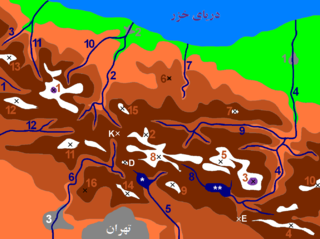
| نقشهٔ البرز مرکزی قلهها
|
رودها
|
شهرها
|


کوههای مرتفع رشته کوه البرز
- دماوند، ۵۶۱۰ متر
- علم کوه، ۴۸۵۰ متر
- خرسان شمالی، ۴۶۸۰ متر
- خرسان جنوبی، ۴۶۵۹ متر
- تخت سلیمان، ۴۶۵۹ متر
- سیاهسنگ، ۴۶۰۹ متر
- هفت خوان، ۴۵۳۷ متر
- چالون، ۴۵۱۶ متر
- سیاه گوک جنوبی، ۴۵۰۰ متر
- سیاه گوک شمالی، ۴۴۴۵ متر
- سیاه کمان، ۴۴۷۲ متر
- شانه کوه، ۴۴۶۵ متر
- کالو، ۴۴۱۲ متر
- گردونکوه، ۴۴۰۲ متر
- میان سه چال، ۴۳۴۸ متر
- آزاد کوه، ۴۳۹۸ متر
- خلنو، ۴۳۷۵ متر
- ناظر بزرگ (شکر لقاس)، ۴۳۵۰ متر
- لشگرک، ۴۲۵۶ متر
- پالان گردن، ۴۲۵۰ متر
- سیالان، ۴۲۵۰ متر
- کلون بستک، ۴۲۰۰ متر
- زرین کوه (ماسه چال)، ۴۲۰۰ متر
- شاه البرز، ۴۲۰۰ متر
- خشچال، ۴۱۸۰ متر
- سرکچال، ۴۱۵۰ متر
- وروشت، ۴۱۰۰ متر
- خرسنگ، ۴۱۰۰ متر
- ناز، ۴۱۰۰ متر
- کهار، ۴۰۵۰ متر
- آلانه سر، ۴۰۵۰ متر
- کرما کوه، ۴۰۲۰ متر
- پسند کوه، ۴۰۰۰ متر
- سیاه لیز، ۳۹۷۵ متر
- توچال، ۳۹۶۰ متر
- مهرچال، ۳۹۲۰ متر
- آتشکوه، ۳۸۵۰ متر
- شاهنشین، ۳۸۵۰ متر
- زرین کوه، ۳۸۵۰ متر
- نیزوا، ۳۸۱۰ متر
- سماموس، ۳۶۲۰ متر
- خرو و نرو، ۳۶۰۹ متر
- کوه لوارک، ۳۵۶۰ متر
- کلکچال، ۳۳۵۰ متر
- کوه لیچه، ۲۸۷۸ متر
- ارفع کوه، ۲۸۵۰ متر
- کوه مزرا، ۲۴۲۰ متر
- کوه سهپایه، ۲۲۰۰ متر
کوه مرتفع غرب[ویرایش]
دیگر کوههای مرتفع شرق[ویرایش]
- شاهوار ۳۹۴۵متر (بلندترین قله البرز شرقی)
- چالویی (دامغان)۳۸۵۰ متر
- گاوکشان ۳۸۱۳متر
- نیزوا ۳۸۱۰ متر
- کهکشان ۳۸۰۰متر
- کرکسی (دامغان) ۳۷۰۰متر
- قله قدمگاه ۳۶۵۱ متر
- نمازگاه ۳۶۰۵متر
- ناقاره خانه ۳۶۰۵متر
- شاهدارکوه (دامغان)۳۲۵۲متر
- بادله کوه (دامغان)۳۲۲۰متر
- بینالود ۳۲۱۱ متر (واقع در رشته کوه بینالود)
- کوه گر (سبزوار) ۲۹۲۴ متر (واقع در رشته کوههای جغتای)
قلل بالای ۴۰۰۰ متر ارتفاع با برجستگی (ارتفاع نسبی) بیش از ۳۰۰ متر[ویرایش]
- دماوند ۵۶۱۰ متر، برجستگی ۴۶۶۱ متر
- علم کوه، ۴۸۲۸ متر، برجستگی ۱۸۴۸ متر
- کالاهو، ۴۴۱۲ متر، برجستگی ۳۰۵ متر
- آزادکوه، ۴۳۹۸ متر، برجستگی ۹۸۰ متر
- خلنو، ۴۳۷۵ متر، برجستگی ۷۴۶ متر
- دوخواهران، ۴۳۱۰ متر، برجستگی ۶۴۴ متر
- ناظر بزرگ (شکر لقاس)، ۴۲۶۰ متر، برجستگی ۵۱۰ متر
- کمانکوه، ۴۲۳۴ متر، برجستگی ۵۳۳ متر
- آویدر، ۴۲۸۶ متر، برجستگی ۵۰۳ متر
- زرین کوه (ماسه چال)، ۴۱۹۸ متر، برجستگی ۴۵۱ متر
- سرکچال، ۴۱۹۴، برجستگی ۳۱۷ متر
- سیالان، ۴۱۶۰ متر، برجستگی ۱۱۶۰ متر
- کلون بستک، ۴۱۵۶ متر، برجستگی ۳۵۹ متر
- شاه البرز، ۴۱۲۵ متر، برجستگی ۹۳۱ متر
- ناز، ۴۱۰۸ متر، برجستگی ۱۰۱۸ متر
- دوبرار، ۴۰۸۲ متر، برجستگی ۱۳۵۲ متر
- کهون، ۴۰۷۵ متر، برجستگی ۳۴۲ متر
- وروشت، ۴۰۲۵ متر، برجستگی ۸۵۲ متر
- کرما کوه، ۴۰۲۰ متر، برجستگی ۳۵۹ متر
- پرچنان، ۴۰۱۵ متر، برجستگی ۱۱۴۴ متر
- سات، ۴۰۰۳ متر، برجستگی ۴۲۸ متر
جستارهای وابسته[ویرایش]
منابع[ویرایش]
- ↑ جنیدی، فریدون (۱۳۸۶). نامه پهلوانی. تهران: انتشارات بلخ وابسته به بنیاد نیشابور. ص. صفحه ۹۸ جلد دوم.
- ↑ DARYĀ-YE MĀZANDARĀN, (Cross-Reference), “DARYĀ-YE MĀZANDARĀN” Encyclopædia Iranica, online edition
- ↑ جعفری، عباس، کوهها و کوهنامه ایران، تهران، ۱۳۶۸ش
- ↑ اهلرس، اکارت (۱۳۸۰). «چشماندازهای زراعی شمال ایران؛ کاربری زمین و ساختار اجتماعی در گیلان و مازندران». ایران: شهر- روستا- عشایر. تهران: منشی. ص. ۷. شابک ۹۶۴-۹۳۰۱۸-۳-۶.
- ↑ بوت، پ.؛ پگی، ش. پ.؛ درش، ژ (۱۳۴۵). «بررسی جغرافیای طبیعی شمال ایران». دانشکده ادبیات و علوم انسانی دانشگاه فردوسی مشهد (۸): ۲۷۳ تا ۲۷۶.
- ↑ «لغتنامه دهخدا». بایگانیشده از اصلی در ۸ نوامبر ۲۰۱۱. دریافتشده در ۲۰ نوامبر ۲۰۱۰.
- ↑ دکتر بابک داریوش، به مناسبت روزجهانی کوهستان، ایسنا، 1398
- ↑ بندهش، نوشته آذرفرنبغ دادگی، ترجمه مهرداد بهار، صفحهٔ ۷۱
- ↑ بندهش، نوشته آذرفرنبغ دادگی، ترجمه مهرداد بهار، صفحه ۷۴−۷۶
- ↑ بیگلری، فریدون 1398 استقرارهای پارینهسنگی قدیم و میانی در شمال البرز و تالش، جنوب دریای کاسپی، فصلنامه پژوهش گردشگری 1 (2)، ص 106-91. دسترسی: http://journal.richt.ir/article-7-76-fa.html بایگانیشده در ۳۰ اکتبر ۲۰۲۰ توسط Wayback Machine
- ↑ بیگلری 1398
- ↑ Berillon G. , Asgari Khaneghah A. (dir.) 2016. Garm Roud: une halte de chasse en Iran, Paléolithique supérieur, Garm Roud: Hunting place in Iran, Upper Paleolithic. Prigonrieux: @rchéo-éditions, IFRI,
- ↑ Jayez, M. , & Vahdati Nasab, H. (2016). A separation: Caspian Mesolithic vs Trialetian lithic industry. A research on the excavated site of Komishan, southeast of the Caspian sea, Iran. Paléorient, 75-94.
- ↑ Mashkour M.. , Chahoud J. , Mahfrouzi A. 2010. Faunal remains from the Epipaleolithic site of Komishan Cave and its dating, preliminary results, Iranian Archaeology, No.1: 32-37
پیوند به بیرون[ویرایش]
| ویکیسفر یک راهنمای سفر برای البرز دارد. |
| مجموعهای از گفتاوردهای مربوط به البرز در ویکیگفتاورد موجود است. |
| در ویکیانبار پروندههایی دربارهٔ البرز موجود است. |
- دید ماهوارهای از البرز خاوری، البرز باختری
- ایالت چهرنگاشتی
- جاذبههای گردشگری استان گیلان
- جاذبههای گردشگری استان مازندران
- دریای خزر
- رشتهکوه البرز
- رشتهکوههای ایران
- زمینچهرهای استان اردبیل
- زمینچهرهای استان البرز
- زمینچهرهای استان تهران
- زمینچهرهای استان سمنان
- زمینچهرهای استان گلستان
- زمینچهرهای استان گیلان
- زمینچهرهای استان مازندران
- فلات ایران
- کوههای استان مازندران
- کوههای ایران
- نام استانها با ریشه پهلوی


