
ایالتهای ایالات متحده آمریکا
(تغییرمسیر از فهرست ایالتهای ایالات متحده آمریکا)
ایالات متحده آمریکا متشکل از ۵۰ ایالت، یک ناحیهٔ فدرال (واشینگتن، دی.سی، پایتخت ایالات متحده)، پنج قلمرو بزرگ، و جزایر کوچک مختلف است.[۱][۲] ۴۸ ایالت بههم پیوسته و واشینگتن، دی.سی. در آمریکای شمالی بین کانادا و مکزیک قرار دارند. آلاسکا منطقهای در شمال غربی آمریکای شمالی است که فقط به کانادا متصل است و هاوایی مجمعالجزایری در میانهٔ اقیانوس آرام است. قلمروهای دیگر ایالات متحده در سراسر اقیانوس آرام و دریای کارائیب پراکندهاند. از زمان تأسیس ایالات متحده در سال ۱۷۷۶، تعداد ایالتها از ۱۳ ایالت اولیه به ۵۰ ایالت کنونی افزایش یافته است.[۳]
فهرست ایالات به همراه اطلاعات کلی شامل وسعت و جمعیت آنها در جدول زیر خلاصه شدهاست.

| نام | IPA | مخفف پستی | پرچم | Statehood | وسعت (کیلومتر مربع) | جمعیت (۲۰۱۱[بروزرسانی]) | مرکز | پرجمعیتترین شهر | Preceding entity | تولید ناخالص داخلی
(میلیون دلار) |
|---|---|---|---|---|---|---|---|---|---|---|
| آلاباما | /ˌæləˈbæmə/ | AL | ۱۴ دسامبر ۱۸۱۹ | ۵۲٬۴۱۹ مایل مربع (۱۳۵٬۷۶۵ کیلومتر مربع) | ۴٬۸۰۲٬۷۴۰ | مانتگامری | بیرمنگام | منطقه آلاباما | ۱۷۴٬۴۰۰ | |
| آلاسکا | /əˈlæskə/ | AK | ۳ ژانویه ۱۹۵۹ | ۶۶۳٬۲۶۷ مایل مربع (۱٬۷۱۷٬۸۵۴ کیلومتر مربع) | ۷۲۲٬۷۱۸ | جونو | انکوریج | منطقه آلاسکا | ۴۵٬۶۰۰ | |
| آریزونا | /ˌær |
AZ | ۱۴ فوریه ۱۹۱۲ | ۱۱۳٬۹۹۸ مایل مربع (۲۹۵٬۲۵۴ کیلومتر مربع) | ۶٬۴۸۲٬۵۰۵ | فینیکس | فینیکس | ناحیه آریزونا | ۲۶۱٬۳۰۰ | |
| آرکانزاس | /ˈɑrkənsɔ:/ | AR | ۱۵ ژوئن ۱۸۳۶ | ۵۲٬۸۹۷ مایل مربع (۱۳۷٬۰۰۲ کیلومتر مربع) | ۲٬۹۳۷٬۹۷۹ | لیتل راک | لیتل راک | ناحیه آرکانزاس | ۱۰۵٬۸۰۰ | |
| کالیفرنیا | /ˌkæl |
CA | ۹ سپتامبر ۱۸۵۰ | ۱۶۳٬۷۰۰ مایل مربع (۴۲۳٬۹۷۰ کیلومتر مربع) | ۳۷٬۶۹۱٬۹۱۲ | ساکرامنتو | لسآنجلس | Directly admitted from واگذاری مکزیک | ۱٬۹۳۶٬۴۰۰ | |
| کلرادو | /ˌkɒləˈrædoʊ/ | CO | ۱ اوت ۱۸۷۶ | ۱۰۴٬۱۸۵ مایل مربع (۲۶۹٬۸۳۷ کیلومتر مربع) | ۵٬۱۱۶٬۷۹۶ | دنور | دنور | ناحیه کلرادو | ۲۵۹٬۷۰۰ | |
| کنتیکت | /kəˈnɛt |
CT | ۹ ژانویه ۱۷۸۸ | ۵٬۵۴۳ مایل مربع (۱۴٬۳۵۶ کیلومتر مربع) | ۳٬۵۸۰٬۷۰۹ | هارتفورد | بریجپورت[۴] | Connecticut Colony, then sovereign state in Confederation | ۲۳۳٬۴۰۰ | |
| دلاور | /ˈdɛləwɛər/ | DE | ۷ دسامبر ۱۷۸۷ | ۲٬۴۹۱ مایل مربع (۶٬۴۵۲ کیلومتر مربع) | ۹۰۷٬۱۳۵ | دوور | ویلمینگتن | Lower Counties on Delaware, then sovereign state in Confederation | ۶۲٬۷۰۰ | |
| فلوریدا | /ˈflɑr |
FL | ۳ مارس ۱۸۴۵ | ۶۵٬۷۵۵ مایل مربع (۱۷۰٬۳۰۴ کیلومتر مربع) | ۱۹٬۰۵۷٬۵۴۲ | تالاهاسی | جکسونویل[۵] | Florida Territory | ۷۵۴٬۰۰۰ | |
| جورجیا | /ˈdʒɔrdʒə/ | GA | ۲ ژانویه ۱۷۸۸ | ۵۹٬۴۲۵ مایل مربع (۱۵۳٬۹۰۹ کیلومتر مربع) | ۹٬۸۱۵٬۲۱۰ | آتلانتا | آتلانتا | Province of Georgia, then sovereign state in Confederation | ۴۰۴٬۶۰۰ | |
| هاوایی | /həˈwaɪ.i:/ | HI | ۲۱ اوت ۱۹۵۹ | ۱۰٬۹۳۱ مایل مربع (۲۸٬۳۱۱ کیلومتر مربع) | ۱٬۳۷۴٬۸۱۰ | هونولولو | هونولولو | Kingdom of Hawaii, then US ناحیه هاوایی | ۶۸٬۹۰۰ | |
| آیداهو | /ˈaɪdəhoʊ/ | ID | ۳ ژوئیه ۱۸۹۰ | ۸۳٬۶۴۲ مایل مربع (۲۱۶٬۶۳۲ کیلومتر مربع) | ۱٬۵۸۴٬۹۸۵ | بویزی | بویزی | ناحیه آیداهو | ۵۴٬۸۰۰ | |
| ایلینوی | /ɪl |
IL | ۳ دسامبر ۱۸۱۸ | ۵۴٬۸۲۶ مایل مربع (۱۴۱٬۹۹۸ کیلومتر مربع) | ۱۲٬۸۶۹٬۲۵۷ | اسپرینگفیلد | شیکاگو | ناحیه ایلینوی، formed from the Northwest Territory | ۶۴۴٬۲۰۰ | |
| ایندیانا | /ˌɪndiˈænə/ | IN | ۱۱ دسامبر ۱۸۱۶ | ۳۶٬۴۱۸ مایل مربع (۹۴٬۳۲۱ کیلومتر مربع) | ۶٬۵۱۶٬۹۲۲ | ایندیاناپولیس | ایندیاناپولیس | ناحیه ایندیانا، تشکیلشده از ناحیه نورٍثوست | ۲۶۷٬۶۰۰ | |
| آیووا | /ˈaɪ. ɵwə/ | IA | ۲۸ دسامبر ۱۸۴۶ | ۵۶٬۲۷۲ مایل مربع (۱۴۵٬۷۴۳ کیلومتر مربع) | ۳٬۰۶۲٬۳۰۹ | دی موین | دی موین | ناحیه آیووا | ۱۴۷٬۲۰۰ | |
| کانزاس | /ˈkænzəs/ | KS | ۲۹ ژانویه ۱۸۶۱ | ۸۲٬۲۷۷ مایل مربع (۲۱۳٬۰۹۶ کیلومتر مربع) | ۲٬۸۷۱٬۲۳۸ | توپیکا | ویچیتا | ناحیه کانزاس | ۱۲۸٬۵۰۰ | |
| کنتاکی[۶] | /k |
KY | ۱ ژوئن ۱۷۹۲ | ۴۰٬۴۰۹ مایل مربع (۱۰۴٬۶۵۹ کیلومتر مربع) | ۴٬۳۶۹٬۳۵۶ | فرانکفورت | لوییویل | Split off from ویرجینیا with that state's consent. The former huge Kentucky County | ۱۶۱٬۴۰۰ | |
| لوئیزیانا | /lu:ˌi:ziˈænə/ | LA | ۳۰ آوریل ۱۸۱۲ | ۵۲٬۲۷۱ مایل مربع (۱۳۵٬۳۸۲ کیلومتر مربع) | ۴٬۵۷۴٬۸۳۶ | باتونروژ | نیواورلئان | ناحیه اورلئان | ۲۱۳٬۶۰۰ | |
| مین | /ˈmeɪn/ | ME | ۱۵ مارس ۱۸۲۰ | ۳۵٬۳۸۵ مایل مربع (۹۱٬۶۴۶ کیلومتر مربع) | ۱٬۳۲۸٬۱۸۸ | آگوستا | پورتلند | Split off from ماساچوست with that state's consent (the former District of Maine) | ۵۳٬۲۰۰ | |
| مریلند | /ˈmɛrələnd/ | MD | ۲۸ آوریل ۱۷۸۸ | ۱۲٬۴۰۷ مایل مربع (۳۲٬۱۳۳ کیلومتر مربع) | ۵٬۸۲۸٬۲۸۹ | آناپولیس | بالتیمور[۷] | Province of Maryland, then sovereign state in Confederation | ۳۰۰٬۰۰۰ | |
| ماساچوست[۶] | /ˌmæsəˈtʃu:s |
MA | ۶ فوریه ۱۷۸۸ | ۱۰٬۵۵۴ مایل مربع (۲۷٬۳۳۶ کیلومتر مربع) | ۶٬۵۸۷٬۵۳۶ | بوستون | بوستون | Province of Massachusetts Bay, then sovereign state in Confederation | ۳۷۷٬۷۰۰ | |
| میشیگان | /ˈmɪʃ |
MI | ۲۶ ژانویه ۱۸۳۷ | ۹۷٬۹۹۰ مایل مربع (۲۵۳٬۷۹۳ کیلومتر مربع) | ۹٬۸۷۶٬۱۸۷ | لنسینگ | دیترویت | Michigan Territory, formed from the Northwest Territory | ۳۷۲٬۴۰۰ | |
| مینهسوتا | /ˌmɪn |
MN | ۱۱ مه ۱۸۵۸ | ۸۶٬۹۴۳ مایل مربع (۲۲۵٬۱۸۱ کیلومتر مربع) | ۵٬۳۴۴٬۸۶۱ | سینت پال | مینئاپولیس | ناحیه مینهسوتا | ۲۶۷٬۱۰۰ | |
| میسیسیپی | /ˌmɪs |
MS | ۱۰ دسامبر ۱۸۱۷ | ۴۸٬۴۳۴ مایل مربع (۱۲۵٬۴۴۳ کیلومتر مربع) | ۲٬۹۷۸٬۵۱۲ | جکسون | جکسون | Mississippi Territory, formed from land donated to the U.S. by Georgia | ۹۸٬۹۰۰ | |
| میزوری | /m |
MO | ۱۰ اوت ۱۸۲۱ | ۶۹٬۷۰۴ مایل مربع (۱۸۰٬۵۳۳ کیلومتر مربع) | ۶٬۰۱۰٬۶۸۸ | جفرسون سیتی | کانزاسسیتی[۸] | Missouri Territory | ۲۴۶٬۷۰۰ | |
| مونتانا | /mɒnˈtænə/ | MT | ۸ نوامبر ۱۸۸۹ | ۱۴۷٬۱۶۵ مایل مربع (۳۸۱٬۱۵۶ کیلومتر مربع) | ۹۹۸٬۱۹۹ | هلنا | بیلینگز | ناحیه مونتانا | ۳۷٬۲۰۰ | |
| نبراسکا | /nəˈbræskə/ | NE | ۱ مارس ۱۸۶۷ | ۷۷٬۴۲۰ مایل مربع (۲۰۰٬۵۲۰ کیلومتر مربع) | ۱٬۸۴۲٬۶۴۱ | لینکلن | اوماها | ناحیه نبراسکا | ۸۹٬۶۰۰ | |
| نوادا | /nəˈvædə/ | NV | ۳۱ اکتبر ۱۸۶۴ | ۱۱۰٬۵۶۷ مایل مربع (۲۸۶٬۳۶۷ کیلومتر مربع) | ۲٬۷۲۳٬۳۲۲ | کارسونسیتی | لاسوگاس | ناحیه نوادا | ۱۲۷٬۵۰۰ | |
| نیو همپشایر | /nu: ˈhæmpʃər/ | NH | ۲۱ ژوئن ۱۷۸۸ | ۹٬۳۵۰ مایل مربع (۲۴٬۲۱۷ کیلومتر مربع) | ۱٬۳۱۸٬۱۹۴ | کنکورد | منچستر[۹] | Province of New Hampshire, then sovereign state in Confederation | ۶۱٬۶۰۰ | |
| نیوجرسی | /nu: ˈdʒɜrzi/ | NJ | ۱۸ دسامبر ۱۷۸۷ | ۸٬۷۲۹ مایل مربع (۲۲٬۶۰۸ کیلومتر مربع) | ۸٬۸۲۱٬۱۵۵ | ترنتون | نیوآرک[۱۰] | Province of New Jersey, then sovereign state in Confederation | ۴۹۷٬۰۰۰ | |
| نیومکزیکو | /nu: ˈmɛks |
NM | ۶ ژانویه ۱۹۱۲ | ۱۲۱٬۶۹۷ مایل مربع (۳۱۵٬۱۹۴ کیلومتر مربع) | ۲٬۰۸۲٬۲۲۴ | سنتا فه | آلبوکرکی | ناحیه نیومکزیکو | ۷۵٬۰۰۰ | |
| نیویورک | /nu: ˈjɔrk/ | NY | ۲۶ ژوئیه ۱۷۸۸ | ۵۴٬۵۵۶ مایل مربع (۱۴۱٬۲۹۹ کیلومتر مربع) | ۱۹٬۴۶۵٬۱۹۷ | آلبانی | نیویورک[۱۱] | Province of New York, then sovereign state in Confederation | ۱٬۱۵۶٬۵۰۰ | |
| کارولینای شمالی | /ˌnɔrθ kærəˈlaɪnə/ | NC | ۲۱ نوامبر ۱۷۸۹ | ۵۳٬۸۶۵ مایل مربع (۱۳۹٬۵۰۹ کیلومتر مربع) | ۹٬۶۵۶٬۴۰۱ | رالی | شارلوت | Province of North Carolina, then sovereign state in Confederation | ۴۰۷٬۴۰۰ | |
| داکوتای شمالی | /ˌnɔrθ dəˈkoʊtə/ | ND | ۲ نوامبر ۱۸۸۹ | ۷۰٬۷۶۲ مایل مربع (۱۸۳٬۲۷۲ کیلومتر مربع) | ۶۸۳٬۹۳۲ | بیسمارک | فارگو | Dakota Territory | ۳۳٬۴۰۰ | |
| اوهایو | /oʊˈhaɪ.oʊ/ | OH | ۱ مارس ۱۸۰۳ | ۴۴٬۸۲۵ مایل مربع (۱۱۶٬۰۹۶ کیلومتر مربع) | ۱۱٬۵۴۴٬۹۵۱ | کلمبوس | کلمبوس[۱۲] | Northwest Territory, land donated to the U.S. by پنسیلوانیا، ویرجینیا، and نیویورک | ۴۸۳٬۴۰۰ | |
| اوکلاهوما | /ˌoʊkləˈhoʊmə/ | OK | ۱۶ نوامبر ۱۹۰۷ | ۶۹٬۹۶۰ مایل مربع (۱۸۱٬۱۹۵ کیلومتر مربع) | ۳٬۷۹۱٬۵۰۸ | اکلاهما سیتی | اکلاهما سیتی | Oklahoma Territory and Indian Territory | ۱۶۰٬۵۰۰ | |
| اورگن | /ˈɒr |
OR | ۱۴ فوریه ۱۸۵۹ | ۹۸٬۴۶۶ مایل مربع (۲۵۵٬۰۲۶ کیلومتر مربع) | ۳٬۸۷۱٬۸۵۹ | سیلم | پورتلند | Oregon Territory | ۱۶۸٬۹۰۰ | |
| پنسیلوانیا[۶] | /ˌpɛns |
PA | ۱۲ دسامبر ۱۷۸۷ | ۴۶٬۰۵۵ مایل مربع (۱۱۹٬۲۸۳ کیلومتر مربع) | ۱۲٬۷۴۲٬۸۸۶ | هریسبورگ | فیلادلفیا | Province of Pennsylvania, then sovereign state in Confederation | ۵۷۵٬۶۰۰ | |
| رودآیلند[۱۳] | /rɵd ˈaɪlənd/ | RI | ۲۹ مه ۱۷۹۰ | ۱٬۲۱۰ مایل مربع (۳٬۱۴۰ کیلومتر مربع) | ۱٬۰۵۱٬۳۰۲ | پراویدنس | پراویدنس | Colony of Rhode Island and Providence Plantations, then sovereign state | ۴۹٬۵۰۰ | |
| کارولینای جنوبی | /ˌsaʊθ kærəˈlaɪnə/ | SC | ۲۳ مه ۱۷۸۸ | ۳۲٬۰۲۰ مایل مربع (۸۲٬۹۳۱ کیلومتر مربع) | ۴٬۶۷۹٬۲۳۰ | کلمبیا | کلمبیا[۱۴] | Province of South Carolina, then sovereign state in Confederation | ۱۶۴٬۳۰۰ | |
| داکوتای جنوبی | /ˌsaʊθ dəˈkoʊtə/ | SD | ۲ نوامبر ۱۸۸۹ | ۷۷٬۱۸۴ مایل مربع (۱۹۹٬۹۰۵ کیلومتر مربع) | ۸۲۴٬۰۸۲ | پییر | سو فالز | Dakota Territory | ۳۹٬۹۰۰ | |
| تنسی | /ˌtɛn |
TN | ۱ ژوئن ۱۷۹۶ | ۴۲٬۱۸۱ مایل مربع (۱۰۹٬۲۴۷ کیلومتر مربع) | ۶٬۴۰۳٬۳۵۳ | نشویل | ممفیس[۱۵] | Formed from western land donated to the U.S. by کارولینای شمالی | ۲۵۰٬۳۰۰ | |
| تگزاس | /ˈtɛksəs/ | TX | ۲۹ دسامبر ۱۸۴۵ | ۲۶۸٬۸۲۰ مایل مربع (۶۹۶٬۲۴۱ کیلومتر مربع) | ۲۵٬۶۷۴٬۶۸۱ | آستین | هیوستون[۱۶] | جمهوری تگزاس | ۱٬۲۰۷٬۴۳۲ | |
| یوتا | /ˈju:tɑ:/ | UT | ۴ ژانویه ۱۸۹۶ | ۸۴٬۸۹۹ مایل مربع (۲۱۹٬۸۸۷ کیلومتر مربع) | ۲٬۸۱۷٬۲۲۲ | سالتلیکسیتی | سالتلیکسیتی | Utah Territory | ۱۱۶٬۹۰۰ | |
| ورمانت | /vərˈmɒnt/ | VT | ۴ مارس ۱۷۹۱ | ۹٬۶۲۳ مایل مربع (۲۴٬۹۲۳ کیلومتر مربع) | ۶۲۶٬۴۳۱ | مونپلیه | برلینگتون | Province of New York and New Hampshire Grants (ownership disputed); Vermont Republic | ۲۶٬۴۰۰ | |
| ویرجینیا[۱۷] | /vərˈdʒɪnjə/ | VA | ۲۵ ژوئن ۱۷۸۸ | ۴۲٬۷۷۴ مایل مربع (۱۱۰٬۷۸۵ کیلومتر مربع) | ۸٬۰۹۶٬۶۰۴ | ریچموند | ویرجینیابیچ[۱۸] | Colony of Virginia, then sovereign state in Confederation | ۴۲۷٬۷۰۰ | |
| واشینگتن | /ˈwɒʃɪŋtən/ | WA | ۱۱ نوامبر ۱۸۸۹ | ۷۱٬۳۶۲ مایل مربع (۱۸۴٬۸۲۷ کیلومتر مربع) | ۶٬۸۳۰٬۰۳۸ | المپیا | سیاتل | سرزمین واشینگتن | ۳۵۱٬۱۰۰ | |
| ویرجینیای غربی | /ˌwɛst vərˈdʒɪnjə/ | WV | ۲۰ ژوئن ۱۸۶۳ | ۲۴٬۲۳۰ مایل مربع (۶۲٬۷۵۵ کیلومتر مربع) | ۱٬۸۵۵٬۳۶۴ | چارلستون | چارلستون | Divided off from ویرجینیا without the consent of that state | ۶۶٬۶۰۰ | |
| ویسکانسین | /wɪsˈkɒns |
WI | ۲۹ مه ۱۸۴۸ | ۶۵٬۴۹۸ مایل مربع (۱۶۹٬۶۳۹ کیلومتر مربع) | ۵٬۷۱۱٬۷۶۷ | مدیسون | میلواکی | Wisconsin Territory, formed from the Northwest Territory | ۲۵۱٬۴۰۰ | |
| وایومینگ | /waɪˈoʊmɪŋ/ | WY | ۱۰ ژوئیه ۱۸۹۰ | ۹۷٬۸۱۸ مایل مربع (۲۵۳٬۳۴۸ کیلومتر مربع) | ۵۶۸٬۱۵۸ | شاین | شاین | ناحیه وایومینگ | ۳۸٬۲۰۰ |
نگارخانه[ویرایش]
-
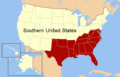 مناطق زیرمجموعه ایالات جنوبی
 -
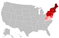 ایالات شمال شرقی


منابع[ویرایش]
- ↑ "Common Core Document of the United States of America: Submitted With the Fourth Periodic Report of the United States of America to the United Nations Committee on Human Rights concerning the International Covenant on Civil and Political Rights". U.S. Department of State, via The Office of Website Management, Bureau of Public Affairs. Retrieved July 9, 2017.
- ↑ "U.S. Insular Areas: application of the U.S. Constitution" (PDF). Government Accountability Office. November 1997. Archived from the original (PDF) on November 3, 2013. Retrieved July 10, 2013.
- ↑ "Doctrine of the Equality of States". Justia Law. Archived from the original on October 19, 2012. Retrieved June 16, 2017.
- ↑ The Hartford-West Hartford-Willimantic Combined Statistical Area is the most populous metropolitan area in کنهتیکت.
- ↑ The Miami-Fort Lauderdale-Miami Beach Metropolitan Statistical Area is the most populous metropolitan area in فلوریدا.
- ↑ ۶٫۰ ۶٫۱ ۶٫۲ Officially called a 'Commonwealth'.
- ↑ Baltimore City and the 12 مریلند counties of the Washington-Baltimore-Northern Virginia Combined Statistical Area form the most populous metropolitan region in Maryland.
- ↑ The City of Saint Louis and the 8 میزوری counties of the St. Louis-St. Charles-Farmington Combined Statistical Area form the most populous metropolitan region in Missouri.
- ↑ The 5 southeastern نیوهمپشایر counties of the Boston-Worcester-Manchester Combined Statistical Area form the most populous metropolitan region in New Hampshire.
- ↑ The 13 northern نیوجرسی counties of the New York-Newark-Bridgeport Combined Statistical Area form the most populous metropolitan region in New Jersey.
- ↑ نیویورک (شهر) is the most populous city in the United States.
- ↑ The Cleveland-Akron-Elyria Combined Statistical Area is the most populous metropolitan area in اوهایو.
- ↑ Full name is State of Rhode Island and Providence Plantations
- ↑ The Greenville-Spartanburg-Anderson Combined Statistical Area is the most populous metropolitan area in کارولینای جنوبی.
- ↑ The Nashville-Davidson-Murfreesboro-Columbia Combined Statistical Area is the most populous metropolitan area in تنسی.
- ↑ The Dallas-Fort Worth Combined Statistical Area is the most populous metropolitan area in تگزاس.
- ↑ رسماً به آن Commonwealth میگویند.
- ↑ The 10 ویرجینیا counties and 6 Virginia cities of the Washington-Baltimore-Northern Virginia Combined Statistical Area form the most populous metropolitan region in Virginia.
پیوند به بیرون[ویرایش]
- اطلاعاتی درباره ایالتها
- راهنمای ایالتها از کتابخانه کنگره
- Tables with areas, populations, densities and more (in order of population)
- Tables with areas, populations, densities and more (alphabetical)
- State and Territorial Governments on USA.gov
- StateMaster – statistical database for US States.
- U.S. States: Comparisons, rankings, demographics
- [۱]
- [۲]