الگو:Location map Trinidad and Tobago
ظاهر
| نام | ترینیداد و توباگو | |||
|---|---|---|---|---|
| مختصات مرزها | ||||
| 11.45 | ||||
| -62.05 | →↕← | -60.4 | ||
| 9.85 | ||||
| وسط نقشه | ۱۰°۳۹′۰۰″شمالی ۶۱°۱۳′۳۰″غربی / ۱۰٫۶۵°شمالی ۶۱٫۲۲۵°غربی | |||
| تصویر | Trinidad and Tobago location map.svg
| |||

| ||||

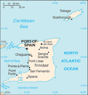
Template:Location map Trinidad and Tobago is a location map definition used to overlay markers and labels on an equirectangular projection map of ترینیداد و توباگو. The markers are placed by عرض جغرافیایی and طول جغرافیایی coordinates on the default map or a similar map image.
Usage[ویرایش]
These definitions are used by the following templates when invoked with parameter "Trinidad and Tobago":
{{Location map|Trinidad and Tobago |...}}{{Location map many|Trinidad and Tobago |...}}{{Location map+|Trinidad and Tobago |...}}{{Location map~|Trinidad and Tobago |...}}
Map definition[ویرایش]
- name = ترینیداد و توباگو
- Name used in the default map caption
- image = Trinidad and Tobago location map.svg
- The default map image, without "Image:" or "File:"
- top = 11.45
- عرض جغرافیایی at top edge of map, in decimal degrees
- bottom = 9.85
- Latitude at bottom edge of map, in decimal degrees
- left = -62.05
- طول جغرافیایی at left edge of map, in decimal degrees
- right = -60.4
- Longitude at right edge of map, in decimal degrees
Examples using location map templates[ویرایش]
Location map, using default map (image)[ویرایش]
{{Location map | Trinidad and Tobago
| width   = 250
| lat_deg = 10.667
| lon_deg = -61.517
| label   = Port of Spain
}}
Location map many, using relief map (image1)[ویرایش]
{{Location map many | Trinidad and Tobago
| relief    = yes
| width     = 250
| caption   = Two locations in Trinidad and Tobago
|
| lat1_deg  = 10.667
| lon1_deg  = -61.517
| label1    = <br/>Port of Spain
| position1 = left
| mark1     = yellow_pog.svg
|
| lat2_deg  = 11.183
| lon2_deg  = -60.738
| label2    = Scarborough
| position2 = bottom
| mark2     = yellow_pog.svg
}}
Location map+, using AlternativeMap[ویرایش]
{{Location map+ | Trinidad and Tobago
| AlternativeMap = Trinidad and Tobago location map Topographic.png
| width   = 250
| caption = Two locations in Trinidad and Tobago
| places  =
  {{Location map~ | Trinidad and Tobago
  | lat_deg  = 10.667
  | lon_deg  = -61.517
  | label    = <br/>Port of Spain
  | position = left
  | mark     = yellow_pog.svg
  }}
  {{Location map~ | Trinidad and Tobago
  | lat_deg  = 11.183
  | lon_deg  = -60.738
  | label    = Scarborough
  | position = bottom
  | mark     = yellow_pog.svg
  }}
}}
See also[ویرایش]
- Location map templates
- Template:Location map, to display one mark and label using latitude and longitude
- Template:Location map many, to display up to nine marks and labels
- Template:Location map+, to display an unlimited number of marks and labels
- Infobox templates incorporating (passing values to) the Location map template
- Template:Infobox airport — alternative map support: AlternativeMap (via pushpin_image)
- Template:Infobox archaeological site
- Template:Infobox artwork
- الگو:جعبه اطلاعات ساختمان
- Template:Infobox casino
- الگو:جعبه سد
- Template:Infobox glacier (via Infobox mountain/map)
- Template:Infobox historic area
- Template:Infobox historic site
- Template:Infobox hot spring (via Infobox map) — alternative map support: relief
- Template:Infobox hotel
- Template:Infobox map (used by other infoboxes) — alternative map support: relief
- Template:Infobox military structure
- Template:Infobox monastery
- الگو:دادان کوه (via Infobox mountain/map)
- Template:Infobox mountain/map (used by mountain, glacier)
- Template:Infobox park (via Infobox map) — alternative map support: relief
- الگو:جعبه اطلاعات منطقه حفاظتشده (via Infobox map) — alternative map support: relief
- الگو:Infobox settlement — alternative map support: AlternativeMap (via pushpin_image)
- Template:Infobox valley (via Infobox map)
- الگو:جعبه اطلاعات آبشار (via Infobox map) — alternative map support: relief
- Template:Infobox World Heritage Site — alternative map support: relief


