منطقه مرکزی، پرتغال
منطقه مرکزی
Região do Centro | |
|---|---|
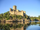
From top left to right: The village of Monsanto, the Festa dos Tabuleiros, the Serra da Estrela, the Castle of Almourol, the town of Nazaré and the city of کویمبرا. | |
| ریشهشناسی: centro, زبان پرتغالی for centre | |
 Location of the Central Region in context of the national borders | |
| مختصات: | |
| کشور | |
| منطقه | Central |
| استانها | بیرا، Ribatejo و Estremadura |
| مرکز | کویمبرا |
| مساحت | |
| • کل | ۲۸۴۶۲ کیلومتر مربع (۱۰۹۸۹ مایل مربع) |
| جمعیت (۲۰۱۱) | |
| • کل | ۲٬۳۲۷٬۰۲۶ (۳rd) |
| منطقه زمانی | یوتیسی +۰ (زمان اروپای غربی) |
| • تابستانی (DST) | یوتیسی +۱ (WEST) |
| شاخص توسعه انسانی (۲۰۱۹) | 0.856[۱] very high · 2nd |
| طبقهبندی واحدهای سرزمینی برای آمار | PT16 |
| تولید ناخالص داخلی (برابری قدرت خرید) | 2013 estimate |
| - Total | € 40.754 billion[۲] |
| - Per capita | € 17,800[۲] |
| تولید ناخالص داخلی (nominal) | 2013 estimate |
| - Total | € 31.780 billion[۳] |
| - Per capita | € 13,900[۲] |
| وبگاه | |
| Statistics from مؤسسه ناسیونال استاتیستیکا (2005); geographic detail from Instituto Geográfico Português (2010) | |
منطقه مرکزی (پرتغالی: Região do Centro) یکی از منطقههای کشور پرتغال است که ۲۸۴۶۲ کیلومتر مربع مساحت و ۲٬۳۲۷٬۰۲۶ نفر جمعیت دارد.
جستارهای وابسته[ویرایش]
منابع[ویرایش]
- ↑ "Sub-national HDI - Area Database - Global Data Lab". hdi.globaldatalab.org (به انگلیسی). Retrieved 12 June 2021.
- ↑ ۲٫۰ ۲٫۱ ۲٫۲ "EU Regions". Eurostat.
- ↑ "Regiões de Portugal". AICEP. Archived from the original on 2014-02-22.
پیوند به بیرون[ویرایش]
| در ویکیانبار پروندههایی دربارهٔ منطقه مرکزی، پرتغال موجود است. |


