
پرونده:Europe mediterranean 1190 cropped.jpg
پروندهٔ اصلی (۷۹۶ × ۷۵۳ پیکسل، اندازهٔ پرونده: ۲۵۷ کیلوبایت، نوع MIME پرونده: image/jpeg)
این پرونده در ویکیانبار موجود است. محتویات صفحهٔ توصیف آن در زیر نمایش داده میشود. |
خلاصه
| توضیح |
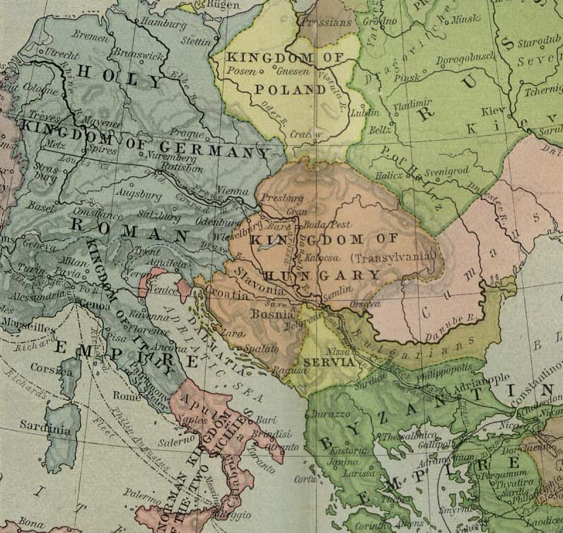
English: Map of Europe, ca. 1190 A.D. |
| تاریخ | بین ۱۹۲۳ و ۱۹۲۶ |
| منبع | Cropped from a map from the Historical Atlas by William Shepherd (1923–26), which is in the public domain in U.S. (http://www.lib.utexas.edu/maps/historical/shepherd/europe_mediterranean_1190.jpg) |
| پدیدآور | William Shepherd |
| دیگر نسخهها | Europe mediterranean 1190.jpg |
اجازهنامه
|
این اثر در کشورهایی و مناطقی که مدت زمان حق تکثیر، عمر پدیدآورنده بعلاوه 70 سال یا کمتر بعد از مرگ او است، در مالکیت عمومی قرار دارد.
| |
| این پرونده تحت قانون حق تکثیر محدودیت آزاد منتشر شده که شامل تمامی حقوق مربوطه و حقوق نزدیک به آن میشود. | |
سیاهه بارگذاری اصلی
- 2009-05-27 11:46 Hobartimus 796×753× (263194 bytes) {{Information |Description = Map of europe, cropped ca. 1190 A.D. |Source = Shrinked version of a map from the ''Historical Atlas'' by William Shepherd (1923-26), which is in the public domain in U.S. ( http://www.lib.utexas.edu/maps/historic
تاریخچهٔ پرونده
روی تاریخ/زمانها کلیک کنید تا نسخهٔ مربوط به آن هنگام را ببینید.
| تاریخ/زمان | بندانگشتی | ابعاد | کاربر | توضیح | |
|---|---|---|---|---|---|
| کنونی | ۱۴ اوت ۲۰۱۱، ساعت ۱۴:۴۸ | | ۷۹۶ در ۷۵۳ (۲۵۷ کیلوبایت) | File Upload Bot (Magnus Manske) | {{BotMoveToCommons|en.wikipedia|year={{subst:CURRENTYEAR}}|month={{subst:CURRENTMONTHNAME}}|day={{subst:CURRENTDAY}}}} {{Information |Description={{en|Map of europe, cropped ca. 1190 A.D.}} |Source=Transferred from [http://en.wikipedia.org en.wikipedia]; |
کاربرد پرونده
صفحههای زیر از این تصویر استفاده میکنند:
کاربرد سراسری پرونده
ویکیهای دیگر زیر از این پرونده استفاده میکنند:
- کاربرد در ar.wikipedia.org
- کاربرد در ary.wikipedia.org
- کاربرد در azb.wikipedia.org
- کاربرد در bn.wikipedia.org
- کاربرد در br.wikipedia.org
- کاربرد در de.wikipedia.org
- کاربرد در el.wikipedia.org
- کاربرد در en.wikipedia.org
- کاربرد در es.wikipedia.org
- کاربرد در et.wikipedia.org
- کاربرد در fr.wikipedia.org
- کاربرد در he.wikipedia.org
- کاربرد در hu.wikipedia.org
- کاربرد در id.wikipedia.org
- کاربرد در id.wikibooks.org
- کاربرد در io.wikipedia.org
- کاربرد در it.wikipedia.org
- کاربرد در ja.wikipedia.org
نمایش استفادههای سراسری از این پرونده.