اقصر: تفاوت میان نسخهها
محتوای حذفشده محتوای افزودهشده
جز r2.7.2) (ربات: افزودن zh-yue:樂蜀 |
درونریزی خودکار مقالهها - به بالا اضافه شد |
||
| خط ۱: | خط ۱: | ||
'''اقصر''' |
|||
{{Infobox settlement |
|||
<!--See Template:Infobox Settlement for additional fields that may be available--> |
|||
<!--See the Table at Infobox Settlement for all fields and descriptions of usage--> |
|||
<!-- Basic info ----------------> |
|||
|name =Luxor <!-- at least one of the first two fields must be filled in --> |
|||
|official_name = |
|||
|other_name = |
|||
|native_name = أَلْأُقْصُر{{سخ}}Al 'Uqṣur |
|||
|native_name_lang =ar <!-- Use ISO639 code, e.g. "fr" for French. |
|||
If there is more than one native name, in different languages, |
|||
enter those names using {{tl|lang}}, instead --> |
|||
| settlement_type = City |
|||
|image_skyline = |
|||
|image_caption = Some features of LUXOR |
|||
|nickname = |
|||
|settlement_type = <!-- e.g. Town, Village, City, etc. --> |
|||
|total_type = <!-- to set a non-standard label for total area and population rows --> |
|||
|motto = |
|||
<!-- images and maps -----------> |
|||
|image_skyline = PONTY-Collage Luxor.png |
|||
|imagesize = 300px |
|||
|image_caption = |
|||
|image_flag = |
|||
|flag_size = |
|||
|image_seal = |
|||
|seal_size = |
|||
|image_shield = |
|||
|shield_size = |
|||
|image_blank_emblem = |
|||
|blank_emblem_type = |
|||
|blank_emblem_size = |
|||
|image_map = |
|||
|mapsize = |
|||
|map_caption = |
|||
|image_map1 = |
|||
|mapsize1 = |
|||
|map_caption1 = |
|||
|image_dot_map = |
|||
|dot_mapsize = |
|||
|dot_map_caption = |
|||
|dot_x = |dot_y = |
|||
|pushpin_map =Egypt <!-- the name of a location map as per http://en.wikipedia.org/wiki/Template:Location_map --> |
|||
|pushpin_label_position = <!-- the position of the pushpin label: left, right, top, bottom, none --> |
|||
|pushpin_map_caption =Location of Luxor within Egypt |
|||
|pushpin_mapsize =۳۰۰ |
|||
<!-- Location ------------------> |
|||
|subdivision_type = [[کشور]] |
|||
|subdivision_name = {{flag|Egypt}} |
|||
|subdivision_type1 = Governorate |
|||
|subdivision_name1 = [[استان اقصر]] |
|||
|subdivision_type2 = |
|||
|subdivision_name2 = |
|||
<!-- Smaller parts (e.g. boroughs of a city) and seat of government --> |
|||
|seat_type = |
|||
|seat = |
|||
|parts_type = |
|||
|parts_style = <!-- =list (for list), coll (for collapsed list), para (for paragraph format) |
|||
Default is list if up to 5 items, coll if more than 5--> |
|||
|parts = <!-- parts text, or header for parts list --> |
|||
|p1 = |
|||
|p2 = <!-- etc. up to p50: for separate parts to be listed--> |
|||
<!-- Politics -----------------> |
|||
|government_footnotes = |
|||
|government_type = |
|||
|leader_title = |
|||
|leader_name = <!--add (no-break space) to leader names to disable automatic links--> |
|||
|leader_title1 = |
|||
|leader_name1 = |
|||
|established_title = <!-- Settled --> |
|||
|established_date = |
|||
<!-- Area ---------------------> |
|||
|area_magnitude = |
|||
|unit_pref = <!--Enter: Imperial, to display imperial before metric--> |
|||
|area_footnotes =<ref name="99stats"/> |
|||
|area_total_km2 =۴۱۶ <!-- ALL fields with measurements are subject to automatic unit conversion--> |
|||
|area_land_km2 = <!--See table @ Template:Infobox Settlement for details on unit conversion--> |
|||
|area_water_km2 = |
|||
|area_total_sq_mi = |
|||
|area_land_sq_mi = |
|||
|area_water_sq_mi = |
|||
|area_water_percent = |
|||
<!-- Elevation --------------------------> |
|||
|elevation_footnotes = <!--for references: use<ref> tags--> |
|||
|elevation_m = |
|||
|elevation_ft = |
|||
|elevation_max_m = |
|||
|elevation_max_ft = |
|||
|elevation_min_m = |
|||
|elevation_min_ft = |
|||
<!-- Population -----------------------> |
|||
|population_as_of =۲۰۱۰ |
|||
|population_footnotes =<ref name="2010stats"/> |
|||
|population_note = |
|||
|population_total =۴۸۷۸۹۶ |
|||
|population_density_km2 = <!--For automatic calculation, any density field may contain: auto --> |
|||
|population_density_sq_mi = |
|||
<!-- General information ---------------> |
|||
|timezone = |
|||
|utc_offset = |
|||
|timezone_DST = |
|||
|utc_offset_DST = |
|||
|coor_pinpoint =<!-- can be used to specify exactly where/what the coordinates refer to --> |
|||
|coordinates_type = |
|||
|coordinates_display = inline,title |
|||
|latd=۲۵ |latm=۴۱ |lats= |latNS=N |
|||
|longd=۳۲ |longm=۳۹ |longs= |longEW=E |
|||
<!-- Area/postal codes & others --------> |
|||
|postal_code_type = <!-- enter ZIP code, Postcode, Post code, Postal code... --> |
|||
|postal_code = |
|||
|area_code = |
|||
|website = [http://www.luxor.gov.eg www.luxor.gov.eg] |
|||
|footnotes = |
|||
}} |
|||
{{coord|25|41|N|32|39|E||display=title}} |
{{coord|25|41|N|32|39|E||display=title}} |
||
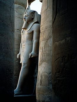
[[پرونده:Egypt.LuxorTemple.02.jpg|thumb|left|260px|نیایشگاه اقصر]] |
[[پرونده:Egypt.LuxorTemple.02.jpg|thumb|left|260px|نیایشگاه اقصر]] |
||
نسخهٔ ۲۹ مهٔ ۲۰۱۲، ساعت ۱۵:۰۶
اقصر
Luxor
أَلْأُقْصُر Al 'Uqṣur | |
|---|---|
 | |
| مختصات: ۲۵°۴۱′ شمالی ۳۲°۳۹′ شرقی / ۲۵٫۶۸۳°شمالی ۳۲٫۶۵۰°شرقی | |
| کشور | |
| Governorate | استان اقصر |
| مساحت | |
| • کل | ۴۱۶ کیلومتر مربع (۱۶۱ مایل مربع) |
| جمعیت (۲۰۱۰)[۲] | |
| • کل | ۴۸۷۸۹۶ |
| وبگاه | |
{{#coordinates:}}: نمیتوان بیش از یک برچسب اصلی در صفحه داشت

اُقصُر (در عربی ألاقصر، در زبانهای اروپایی Luxor) یکی از شهرهای کشور مصر است.
نام اقصر جمع قصر است و اشاره به کاخهای باستانی فرعونهای مصر دارد که در این منطقه قرار دارند و به این خاطر اقصر از شهرهای مهم گردشگری مصر بشمار میآید. شهر اقصر 200,000 نفر جمعیت دارد و در محل شهر باستانی تب بنا شده است.
جستارهای وابسته
منبع
ویکیپدیای انگلیسی.
| در ویکیانبار پروندههایی دربارهٔ اقصر موجود است. |

