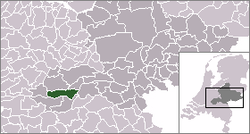
هافتن
هافتن | |
|---|---|
Village | |
 موقعیت هافتن در نقشه | |
 The village centre (red) and the statistical district (light green) of Haaften in the municipality of Neerijnen. The green area also comprises the smaller villages of Hellouw and Tuil. The dark green area in the southeast is Overnachtingshaven Haaften, a harbour where barges can berth for a few days. | |
| مختصات: ۵۱°۴۹′۱″ شمالی ۵°۱۲′۴۲″ شرقی / ۵۱٫۸۱۶۹۴°شمالی ۵٫۲۱۱۶۷°شرقی | |
| کشور | هلند |
| استان | خلدرلاند |
| فهرست شهرستانهای هلند | نیرینن |
| جمعیت (2008) | |
| • کل | ۲٬۸۸۱ |
| منطقه زمانی | یوتیسی +۱ (زمان) |
| • تابستانی (DST) | یوتیسی +2 (ساعت تابستانی اروپای مرکزی) |
| Dialing code | 0418, 0345 |
هافتن (به هلندی: Haaften) یک منطقهٔ مسکونی در هلند است که در نیرینن واقع شدهاست.[۱] هافتن ۲٬۸۸۱ نفر جمعیت دارد.
جستارهای وابسته[ویرایش]
منابع[ویرایش]
پیوند به بیرون[ویرایش]
| در ویکیانبار پروندههایی دربارهٔ هافتن موجود است. |

