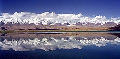
قرهکول (سینکیانگ)
| قرهکول | |
|---|---|
 نمایی از دریاچه | |
Location of the Karakul lake within the greater پامیر region | |
| موقعیت | سینکیانگ |
| مختصات | ۳۸°۲۶′۴۴″ شمالی ۷۵°۰۳′۱۳″ شرقی / ۳۸٫۴۴۵۵۶°شمالی ۷۵٫۰۵۳۶۱°شرقی |
| کشورهای حوضه | China |
| مساحتِ رو | ۴٫۸ کیلومتر مربع (۱٫۹ مایل مربع) |
| بیشترین ژرفا | ۲۴۲ متر (۷۹۴ فوت) |
| ارتفاع سطح | ۳٬۶۴۵ متر (۱۱٬۹۵۹ فوت) |
 | |
قرهکول (اویغوری: قاراكۆل) یک دریاچه در استان سینکیانگ کشور چین است.[۱][۲]
منابع[ویرایش]
- ↑ Aichner, Bernhard; Feakins, Sarah. J.; Lee, Jung-Eun; Herzschuh, Ulrike; Liu, Xingqi (2015). "High-resolution leaf wax carbon and hydrogen isotopic record of the late Holocene paleoclimate in arid Central Asia". Climate of the Past. 11: 619–633. doi:10.5194/cp-11-619-2015.
- ↑ Liu, Xingqi; Herzschuh, Ulrike; Wang, Yongbo; Kuhn, Gerhard; Yu, Zhitong (2014). "Glacier fluctuations of Muztagh Ata and temperature changes during the late Holocene in westernmost Tibetan Plateau, based on glaciolacustrine sediment records". Geophysical Research Letters. 41 (17): 6265–6273. doi:10.1002/2014GL060444.
- مشارکتکنندگان ویکیپدیا. «Karakul (Xinjiang)». در دانشنامهٔ ویکیپدیای انگلیسی، بازبینیشده در ۲۲ آوریل ۲۰۲۴.
پیوند به بیرون[ویرایش]
| در ویکیانبار پروندههایی دربارهٔ قرهکول (سینکیانگ) موجود است. |

