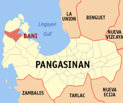
بنی، پانگاسینان
ظاهر
بنی، پانگاسینان | |
|---|---|
 | |
 موقعیت بنی، پانگاسینان در نقشه | |
| مختصات: ۱۶°۱۲′ شمالی ۱۱۹°۵۱′ شرقی / ۱۶٫۲۰۰°شمالی ۱۱۹٫۸۵۰°شرقی | |
| کشور | |
| Region | Ilocos (Region I) |
| استانهای فیلیپین | پانگاسینان |
| District | 1st district of Pangasinan |
| تأسیسشده | ۱۷۶۹ |
| Barangay | ۲۷ |
| مدیریت | |
| • شهردار | Gwen Palafox Yamamoto |
| • معاون شهردار | Filipina C. Rivera |
| • Electorate | ۳۱٬۶۸۷ voters ([[Philippine general election, خطا: زمان نامعتبر|خطا: زمان نامعتبر election]]) |
| مساحت | |
| • کل | ۱۷۹٫۶۵ کیلومتر مربع (۶۹٫۳۶ مایل مربع) |
| جمعیت (خطا: زمان نامعتبر سرشماری) | |
| • کل | ۵۲٬۶۰۳ |
| منطقه زمانی | یوتیسی +۸ (PST) |
| ZIP code | 2407 |
| PSGC | 015508000 |
| Dialing code | +63 (0)75 |
| Income class | 2nd municipal income class |
| Revenue | ₱ 14,482,376.41 (2016)[۳] |
| Poverty incidence | 17.57 (2012)[۴] |
| وبگاه | |
بنی، پانگاسینان (به لاتین: Bani, Pangasinan) یک منطقهٔ مسکونی در فیلیپین است که در پانگاسینان واقع شدهاست.[۵]
خصوصیات[ویرایش]
بنی ۱۷۹٫۶۵ کیلومترمربع مساحت دارد.
جستارهای وابسته[ویرایش]
منابع[ویرایش]
- ↑ "Official City/Municipal 2013 Election Results". Intramuros, Manila, Philippines: Commission on Elections (COMELEC). 1 July 2013. Retrieved 3 September 2013.
- ↑ "Province: PANGASINAN". PSGC Interactive. Makati City, Philippines: National Statistical Coordination Board. Archived from the original on 14 November 2012. Retrieved 22 November 2012.
- ↑ "Pangasinan: Cities and Municipalities Competitiveness Index". Makati City, Philippines: National Competitiveness Council (Philippines). Archived from the original on 28 January 2017. Retrieved 28 January 2017.
- ↑ "PSA Releases the 2012 Municipal and City Level Poverty Estimates". Quezon City, Philippines: Philippine Statistics Authority. Archived from the original on 28 January 2017. Retrieved 28 January 2017.
- ↑ مشارکتکنندگان ویکیپدیا. «Bani, Pangasinan». در دانشنامهٔ ویکیپدیای انگلیسی.
پیوند به بیرون[ویرایش]
در ویکیانبار پروندههایی دربارهٔ بنی، پانگاسینان موجود است.


