
پرونده:1856 Kiepert Map of Lebanon - Geographicus - Lebanon-kiepert-1856.jpg

پروندهٔ اصلی (۳٬۰۰۰ × ۳٬۶۷۵ پیکسل، اندازهٔ پرونده: ۲٫۴۵ مگابایت، نوع MIME پرونده: image/jpeg)
این پرونده در ویکیانبار موجود است. محتویات صفحهٔ توصیف آن در زیر نمایش داده میشود. |
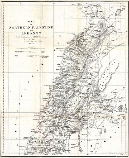
| هاینریش کیپرت: Map of Northern Palestine and Lebanon Chiefly from the Routes of E. Robinson & others.
( |
||||||||||||||||||||||||
|---|---|---|---|---|---|---|---|---|---|---|---|---|---|---|---|---|---|---|---|---|---|---|---|---|
| هنرمند |
|
|||||||||||||||||||||||
| عنوان |
Map of Northern Palestine and Lebanon Chiefly from the Routes of E. Robinson & others. |
|||||||||||||||||||||||
| توضیح |
English: An uncommon map of Lebanon by the classical scholar and cartographer H. Kiepert. Covers all of modern day Lebanon as well as parts of adjacent Israel, Palestine, Jordan and Syria. This map is based on the 1838 travels of E. Robinson and E. Smith in this area. Robinson and Smith, in search of unidentified Biblical sites, traveled throughout the Middle East but most particularly in modern day Israel, Palestine, Lebanon, Egypt, Jordan, and Syria. The duo used local traditions as well as established Biblical scholarship to identify a number of important sites. This map is largely the result of their research and work. Their route, shown in red, leads Israel northwards to Tyre then skirts the coast to Beiruit. Most place names are transliterations of Arabic though biblical references are included where appropriate. This map was drawn by Heinrich Kiepert, a noted expert on historical cartography, for Robinson’s important work Biblical Researches in Palestine, and in the Adjacent Regions. |
|||||||||||||||||||||||
| تاریخ | ۱۸۵۶ (undated) | |||||||||||||||||||||||
| ابعاد | بلندی: ۲۰٫۰ اینچ (۵۰٫۸ سانتیمتر)؛ عرض: ۱۶٫۵ اینچ (۴۱٫۹ سانتیمتر) | |||||||||||||||||||||||
| آیدی |
Geographicus link: Lebanon-kiepert-1856 |
|||||||||||||||||||||||
| منبع/عکاس |
Robinson, E., and Smith, E., Biblical Researches in Palestine, and in the Adjacent Regions. A Journal of Travels in the Year 1838. (Boston: Crocker & Brewster) 1856.
|
|||||||||||||||||||||||
| اجازهنامه (استفادهٔ مجدد از این پرونده) |
|
|||||||||||||||||||||||
Loescher_%26_btv1b8453164n_(cropped).jpg)
تاریخچهٔ پرونده
روی تاریخ/زمانها کلیک کنید تا نسخهٔ مربوط به آن هنگام را ببینید.
| تاریخ/زمان | بندانگشتی | ابعاد | کاربر | توضیح | |
|---|---|---|---|---|---|
| کنونی | ۲۴ مارس ۲۰۱۱، ساعت ۲۲:۱۶ | | ۳٬۰۰۰ در ۳٬۶۷۵ (۲٫۴۵ مگابایت) | BotMultichillT | {{subst:User:Multichill/Geographicus |link=http://www.geographicus.com/P/AntiqueMap/Lebanon-kiepert-1856 |product_name=1856 Kiepert Map of Lebanon |map_title=Map of Northern Palestine and Lebanon Chiefly from the Routes of E. Robinson & others. |descripti |
کاربرد پرونده
صفحههای زیر از این تصویر استفاده میکنند:
کاربرد سراسری پرونده
ویکیهای دیگر زیر از این پرونده استفاده میکنند:
- کاربرد در ar.wikipedia.org
- کاربرد در en.wikipedia.org
- History of Lebanon
- Baalbek
- Lebanese Civil War
- Greater Lebanon
- Cedar Revolution
- Assassinations linked to the Cedar Revolution
- Good Fence
- Lebanese Independence Day
- History of ancient Lebanon
- Template:History of Lebanon
- 2006–2008 Lebanese protests
- Youssef Bey Karam
- Phoenicia under Assyrian rule
- Phoenicia under Babylonian rule
- List of attacks in Lebanon
- 2008 Lebanon conflict
- Wikipedia:WikiProject Lebanon/Resources
- Timeline of Lebanese history
- Wikipedia:WikiProject Lebanon/Templates
- History of Lebanon under Ottoman rule
- Phoenicia under Hellenistic rule
- Phoenicia under Roman rule
- Mount Lebanon Mutasarrifate
- List of wars involving Lebanon
- List of rivers of Lebanon
- User:༆/History of Asia templates
- Timeline of Beirut
- Harfush dynasty
- List of years in Lebanon
- Tomb of the Unknown Soldier (Lebanon)
- History of Tyre, Lebanon
- Second Lebanese Republic
- Template:History of Lebanon/doc
- History of Beirut
- Kisrawan
- 5th century in Lebanon
- 4th century in Lebanon
- 6th century in Lebanon
- 7th century in Lebanon
- 8th century in Lebanon
- 9th century in Lebanon
- 10th century in Lebanon
- 3rd century in Lebanon
- 2nd century in Lebanon
- 1st century in Lebanon
- History of Tripoli, Lebanon
- Double Qaim-Maqamate of Mount Lebanon
- User:Red Phoenician/Tur Lebnon
- Draft:History of Baalbek
نمایش استفادههای سراسری از این پرونده.