دنیدن: تفاوت میان نسخهها
محتوای حذفشده محتوای افزودهشده
جز ربات ردهٔ همسنگ (۳۰.۱) +مرتب (۱۴.۹ core): + رده:بنیانگذاریهای ۱۸۴۸ (میلادی) در نیوزیلند |
Luckie Luke (بحث | مشارکتها) بدون خلاصۀ ویرایش برچسب: افزودن تگهای خالی |
||
| خط ۱: | خط ۱: | ||
{{Infobox settlement |
|||
{{Coord|45|52|0|S|170|30|0|E|type:city_region:NZ-OTA|display=title}} |
|||
<!-- Basic info ---------------->| name = Dunedin |
|||
{{جعبه شهرهای نیوزیلند |
|||
| official_name = |
|||
|نام= دنیدن |
|||
| native_name = {{Native name|mi|Ōtepoti|nbsp=omit}} |
|||
|نگاره= Dunedin Railway Station2.jpg |
|||
| native_name_lang = mi |
|||
|شرح نگاره= شهر دنیدن |
|||
| |
| other_name = |
||
| settlement_type = [[List of cities in New Zealand|City]] |
|||
|مساحت= ۲۵۵ |
|||
| image_skyline = Dunedin Collage.jpg |
|||
|شهر و حومه= ۱۲۳٬۷۰۰ |
|||
| imagesize = 270px |
|||
|جمعیت= ۱۲۳٬۷۰۰ (تخ. ۲۰۰۹) |
|||
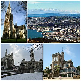
| image_caption = Clockwise from top: [[First Church of Otago]], cityscape seen from Signal Hill lookout, [[Larnach Castle]], Anglican Cathedral and Town Hall on [[The Octagon, Dunedin|The Octagon]] |
|||
|رتبه جمعیت= پنجم در کشور |
|||
| image_shield = Dunedin city coa.gif |
|||
|جمعیت شهر و حومه= ۱۲۳٬۷۰۰ (تخ. ۲۰۰۹) |
|||
| image_blank_emblem = Dunedin CC logo.jpg |
|||
|رتبه جمعیت شهر و حومه= پنجم |
|||
| image_flag = Dunedin City flag.png |
|||
|شهردار= [[پیتر چین]] |
|||
| blank_emblem_size = 150px |
|||
|منطقه زمانی= [[زمان استاندارد جهانی|استاندارد]] مثبت ۱۲ |
|||
| nicknames = Edinburgh of the South;<ref>{{cite web|title=Southern style|url=http://www.stuff.co.nz/life-style/fashion/2277129/Southern-style|date=19 March 2009|work=[[Stuff (website)|Stuff]]|access-date=15 March 2011|archive-url=https://web.archive.org/web/20121023135134/http://www.stuff.co.nz/life-style/fashion/2277129/Southern-style|archive-date=23 October 2012|url-status=live}}</ref><br />Dunners (colloquial)<ref name="NZHerald10569715">{{cite web|url=http://www.nzherald.co.nz/sport/news/article.cfm?c_id=4&objectid=10569715|title=Supersport's Good Week / Bad Week: An unhappy spectator|date=1 May 2009|work=[[نیوزیلند هرالد]]|access-date=18 September 2009|archive-url=https://web.archive.org/web/20120406102339/http://www.nzherald.co.nz/sport/news/article.cfm?c_id=4&objectid=10569715|archive-date=6 April 2012|url-status=live}}</ref> |
|||
|پیششماره= 03 |
|||
| motto = <!-- images and maps -----------> |
|||
| image_map = {{Location map many| New Zealand Dunedin area |
|||
| width = 280 |
|||
| float = center |
|||
| caption = |
|||
| alt = Dunedin City |
|||
| border = infobox |
|||
| label = [[Middlemarch, New Zealand|Middlemarch]] |
|||
| pos1 = left |
|||
| bg1 = lightblue |
|||
| marksize = 8 |
|||
| lat1_deg = -45.560606 |
|||
| lon1_deg = 170.128083 |
|||
| label2 = [[Princes Street, Dunedin|City Centre]] |
|||
| pos2 = left |
|||
| bg2 = lightblue |
|||
| mark2size = 8 |
|||
| lat2_deg = -45.874319 |
|||
| lon2_deg = 170.503298 |
|||
| label5 = [[Port Chalmers]] |
|||
| pos5 = left |
|||
| label5_width= 7 |
|||
| bg5 = lightblue |
|||
| lat5_deg = -45.813574 |
|||
| lon5_deg = 170.621397 |
|||
| label6 = [[فرودگاه بینالمللی دنیدن]] |
|||
| pos6 = left |
|||
| bg6 = lightblue |
|||
| lat6_deg = -45.926279 |
|||
| lon6_deg = 170.202683 |
|||
| label7 = [[Waikouaiti]] |
|||
| pos7 = left |
|||
| bg7 = lightblue |
|||
| lat7_deg = -45.599507 |
|||
| lon7_deg = 170.669660 |
|||
}} |
|||
<!-- Location ------------------>| coordinates = {{Coord|45|52|S|170|30|E|type:city_region:NZ-OTA|display=inline,title}} |
|||
<!-- Area/postal codes & others -------->| subdivision_type = Country |
|||
| subdivision_name = New Zealand |
|||
| subdivision_type1 = [[منطقههای نیوزیلند]] |
|||
| subdivision_type2 = [[Territorial authorities of New Zealand|Territorial authority]] |
|||
| subdivision_name1 = [[اوتاگو]] |
|||
| subdivision_name2 = [[Dunedin City Council]] |
|||
<!-- Smaller parts (e.g. boroughs of a city) and seat of government -->| established_title = Settled by Māori |
|||
| established_date = [[circa|c.]] 1300<ref name="settled">{{cite encyclopedia|url=http://www.teara.govt.nz/en/when-was-new-zealand-first-settled/1|title=When was New Zealand first settled? – The date debate|encyclopedia=Te Ara: The Encyclopedia of New Zealand|last=Irwin|first=Geoff|author2=Walrond, Carl|date=4 March 2009|access-date=14 February 2010|archive-url=https://web.archive.org/web/20100524045444/http://www.teara.govt.nz/en/when-was-new-zealand-first-settled/1|archive-date=24 May 2010|url-status=live}}</ref> |
|||
| established_title1 = Settled by Europeans |
|||
| established_date1 = 1848 |
|||
| established_title2 = Incorporated<ref>[https://web.archive.org/web/20051205234340/http://www.cityofdunedin.com/city/?page=archives_townbrd1 Dunedin Town Board<!-- Bot generated title -->]</ref> |
|||
| established_date2 = 1855 |
|||
| named_for = ''Dùn Èideann'' – [[گیلیک اسکاتلندی]] name for [[ادینبرا]] |
|||
<!-- Area --------------------->| seat_type = NZ Parliament |
|||
| seat = [[Dunedin (New Zealand electorate)|Dunedin]]<br/>[[Taieri (New Zealand electorate)|Taieri]]<br/>[[Te Tai Tonga]] ([[Māori electorates|Māori]]) |
|||
<!-- Politics ----------------->| government_footnotes = <ref name=mayor>{{cite web|url=http://www.dunedin.govt.nz/your-council/councillors/mayor-dave-cull|title=Mayor Dave Cull|publisher=Dunedin City Council|access-date=14 February 2015|archive-url=https://web.archive.org/web/20150923221201/http://www.dunedin.govt.nz/your-council/councillors/mayor-dave-cull|archive-date=23 September 2015|url-status=live}}</ref> |
|||
| government_type = |
|||
| leader_title = [[Mayor of Dunedin|Mayor]] |
|||
| leader_name = [[Aaron Hawkins (politician)|Aaron Hawkins]] ([[Green Party of Aotearoa New Zealand|Green]]) |
|||
| leader_title1 = Deputy Mayor |
|||
| leader_name1 = Christine Garey |
|||
| leader_title2 = MPs |
|||
| leader_name2 = {{فهرست ساده| |
|||
* [[David Clark (New Zealand politician)|David Clark]] ([[حزب کارگر نیوزیلند]]) |
|||
* [[Ingrid Leary]] ([[حزب کارگر نیوزیلند]]) |
|||
* [[Rino Tirikatene]] ([[حزب کارگر نیوزیلند]]) |
|||
}} |
}} |
||
| total_type = Territorial |
|||
| unit_pref = <!--Enter: Imperial, to display imperial before metric--> |
|||
| area_footnotes = |
|||
| area_magnitude = |
|||
| area_total_km2 = 3314<!--Region--> <!-- ALL fields with measurements are subject to automatic unit conversion--> |
|||
| area_land_km2 = <!--See table @ Template:Infobox Settlement for details on unit conversion--> |
|||
| area_water_km2 = |
|||
| area_water_percent = <!-- Elevation --------------------------> |
|||
| area_urban_km2 = 255 |
|||
| elevation_footnotes = <!--for references: use<ref> </ref> tags--> |
|||
| elevation_m = |
|||
| elevation_min_m = <!-- Population -----------------------> |
|||
| population_total = {{formatnum:{{NZ population data 2018|Dunedin city|y}}|R}} |
|||
| population_as_of = {{NZ population data 2018|||y}} |
|||
| population_footnotes = {{NZ population data 2018||||y}} |
|||
| population_density_km2 = auto |
|||
| population_urban = {{formatnum:{{NZ population data 2018||y}}|R}} |
|||
| population_density_urban_km2 = auto |
|||
| population_demonym = Dunedinite |
|||
<!-- General information --------------->| population_note = |
|||
| postal_code_type = Postcodes <!-- enter ZIP code, Postcode, Post code, Postal code... --> |
|||
| postal_code = 9010, 9011, 9012, 9013, 9014, 9016, 9018, 9022, 9023, 9024, 9035, 9076, 9077, 9081, 9082, 9092 |
|||
| area_code = 03 |
|||
| unemployment_rate = |
|||
| website = [http://www.dunedinnz.com/ www.DunedinNZ.com] |
|||
| footnotes = |
|||
| elevation_max_m = |
|||
| timezone = [[Time in New Zealand|NZST]] |
|||
| utc_offset = +12 |
|||
| timezone_DST = NZDT |
|||
| utc_offset_DST = +13 |
|||
| blank_name = Local {{Lang|mi|[[iwi]]|italic=no}} |
|||
| blank_info = {{Lang|mi|[[Ngāi Tahu]]|italic=no}} |
|||
}} |
|||
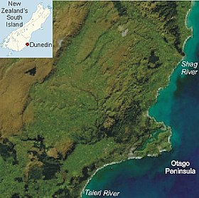
'''دنیدن''' {{به انگلیسی|Dunedin}} دومین [[شهر]] بزرگ [[جزیره جنوبی]] در [[نیوزیلند]] بعد از [[کرایست چرچ]] و مرکز [[استان اتاگو]]. |
'''دنیدن''' {{به انگلیسی|Dunedin}} دومین [[شهر]] بزرگ [[جزیره جنوبی]] در [[نیوزیلند]] بعد از [[کرایست چرچ]] و مرکز [[استان اتاگو]]. |
||
[[دانشگاه اتاگو]] در این شهر قرار دارد. |
[[دانشگاه اتاگو]] در این شهر قرار دارد. |
||
{{ |
{{پاککن}} |
||
{{ |
{{سراسرنما|Dunedin Panorama.jpg|800px|}} |
||
{{ |
{{سراسرنما|Mount Cargill 2.jpg|800px|}} |
||
{{ |
{{سراسرنما|Mount Cargill.jpg|800px|}} |
||
{{ |
{{سراسرنما|Flagstaff Hill.jpg|800px|}} |
||
{{ |
{{سراسرنما|Dunedin_pano_from_signal_hill.jpg|800px|}} |
||
{{دادههای کتابخانهای}} |
{{دادههای کتابخانهای}} |
||
نسخهٔ ۱ فوریهٔ ۲۰۲۱، ساعت ۰۲:۳۸
Dunedin
Ōtepoti (مائوری) | |
|---|---|
 Clockwise from top: First Church of Otago, cityscape seen from Signal Hill lookout, Larnach Castle, Anglican Cathedral and Town Hall on The Octagon | |
| لقب(ها): | |
| مختصات: ۴۵°۵۲′ جنوبی ۱۷۰°۳۰′ شرقی / ۴۵٫۸۶۷°جنوبی ۱۷۰٫۵۰۰°شرقی | |
| Country | New Zealand |
| منطقههای نیوزیلند | اوتاگو |
| Territorial authority | Dunedin City Council |
| Settled by Māori | c. 1300[۳] |
| Settled by Europeans | 1848 |
| Incorporated[۴] | 1855 |
| وجه تسمیه | Dùn Èideann – گیلیک اسکاتلندی name for ادینبرا |
| NZ Parliament | Dunedin Taieri Te Tai Tonga (Māori) |
| مدیریت | |
| • Mayor | Aaron Hawkins (Green) |
| • Deputy Mayor | Christine Garey |
| • MPs | |
| مساحت | |
| • Territorial | ۳۳۱۴ کیلومتر مربع (۱۲۸۰ مایل مربع) |
| • شهری | ۲۵۵ کیلومتر مربع (۹۸ مایل مربع) |
| جمعیت (June 2020)[۶] | |
| • Territorial | ۱۳۴٬۱۰۰ |
| • تراکم | ۴۰/کیلومتر مربع (۱۰۰/مایل مربع) |
| نام اهلیت(ها) | Dunedinite |
| منطقه زمانی | یوتیسی +۱۲ (NZST) |
| • تابستانی (DST) | یوتیسی +13 (NZDT) |
| Postcodes | 9010, 9011, 9012, 9013, 9014, 9016, 9018, 9022, 9023, 9024, 9035, 9076, 9077, 9081, 9082, 9092 |
| پیششماره(های) تلفن | 03 |
| Local iwi | Ngāi Tahu |
| وبگاه | |
دنیدن (به انگلیسی: Dunedin) دومین شهر بزرگ جزیره جنوبی در نیوزیلند بعد از کرایست چرچ و مرکز استان اتاگو. دانشگاه اتاگو در این شهر قرار دارد.
- ↑ "Southern style". Stuff. 19 March 2009. Archived from the original on 23 October 2012. Retrieved 15 March 2011.
- ↑ "Supersport's Good Week / Bad Week: An unhappy spectator". نیوزیلند هرالد. 1 May 2009. Archived from the original on 6 April 2012. Retrieved 18 September 2009.
- ↑ Irwin, Geoff; Walrond, Carl (4 March 2009). "When was New Zealand first settled? – The date debate". Te Ara: The Encyclopedia of New Zealand. Archived from the original on 24 May 2010. Retrieved 14 February 2010.
- ↑ Dunedin Town Board
- ↑ "Mayor Dave Cull". Dunedin City Council. Archived from the original on 23 September 2015. Retrieved 14 February 2015.
- ↑ "Population estimate tables - NZ.Stat". Statistics New Zealand. Retrieved 22 October 2020.


