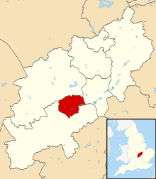
نورثهمپتون
Borough of Northampton | |
|---|---|
Town & Borough | |
 Northampton Guildhall, built 1861-4 by E. W. Godwin | |
 Northampton | |
| مختصات: ۵۲°۱۳′۴۹″شمالی ۰°۵۳′۳۸″غربی / ۵۲٫۲۳۰۳۷۴۸°شمالی ۰٫۸۹۳۷۵۲۷°غربی | |
| کشور | United Kingdom |
| کشور | انگلستان |
| ناحیه | میدلند شرقی |
| Ceremonial county | نورتهمپتونشر |
| Admin. HQ | Northampton |
| مدیریت | |
| • نوع | Northampton Borough Council Mayor of the Borough and Chair 2011–2012 Cllr Jamie Lane[۱] |
| • Leadership: | Leader & Cabinet Cllr David Palethorpe[۱] |
| • Executive: | Conservative |
| • MPs: | Brian Binley, Michael Ellis |
| مساحت | |
| • کل | ۳۱٫۱۸ مایل مربع (۸۰٫۷۶ کیلومتر مربع) |
| رتبه مساحت | 237th |
| جمعیت (2008 est.) | |
| • کل | ۲۲۴٬۶۱۰ |
| • رتبه | Ranked 78th |
| • تراکم | ۷۲۰۰/مایل مربع (۲۸۰۰/کیلومتر مربع) |
| نام اهلیت(ها) | Northamptonian |
| منطقه زمانی | یوتیسی +۰ (ساعت گرینویچ) |
| • تابستانی (DST) | یوتیسی +۱ (ساعت تابستانی بریتانیا) |
| Postcode | |
| ONS code | 34UF (ONS) E07000154 (GSS) |
| Ethnicity | 86.1% White 6.4% S.Asian 3.9% Black British 2.1% Mixed Race 2.3% Chinese or other[۲] |
| وبگاه | |
نورثهمپتون (به انگلیسی: Northampton) شهری در کشور انگلستان است که این کشور خود بخشی از بریتانیا محسوب میشود. این شهر در سال ۱۹۹۱ میلادی ۱۷۹٫۵۹۶ نفر جمعیت داشته و در سرشماری سال ۲۰۰۱ جمعیت آن به ۱۸۹٫۴۷۴ نفر رسیدهاست. میزان رشد سالانهٔ جمعیت نورثهمپتون -۰٫۳ درصد میباشد و جمعیت این شهر در سال ۲۰۱۲ به ۱۸۳٫۳۹۳ نفر تغییر یافت.[۳]
جستارهای وابسته[ویرایش]
منابع[ویرایش]
- ↑ ۱٫۰ ۱٫۱ NBC Councillors 2007–2011 Accessed 16 August 2011
- ↑ "Office for National Statistics (Northampton Area)". Archived from the original on 12 September 2012. Retrieved 19 August 2012.
- ↑ "United Kingdom: largest cities and towns and statistics of their population" (به انگلیسی). world-gazetteer. Archived from the original on 5 December 2012. Retrieved 22 May 2012.
ردهها:
- نورثهمپتون
- بازار محلی در نورتهمپتونشر
- دولت محلی در نورتهمپتونشر
- شهرکها در نورتهمپتونشر
- شهرکهای جدید در انگلستان
- شهرکهای دارای کلیساهای جامع در بریتانیا
- شهرکهای شهرستانها در انگلستان
- شهرهای جدید آغازشده در دهه ۱۹۶۰ (میلادی)
- محلههای مدنی در نورثهمپتونشر
- میدلند شرقی
- نورثهمپتونشر
- بخش نورثهمپتونشر غربی
