کومیناتو، آئوموری
مختصات: مختصات: عرض جغرافیایی وارد نشدهاست
کومیناتو، آئوموری
小湊町 | |
|---|---|
Former municipality | |
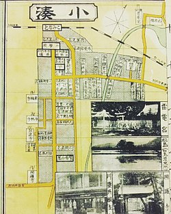
 A map of Kominato as it was in 1926. The Ōshū Kaidō followed the thick yellow line from the center-right edge of the map, turned south through the center of the town, then west, leaving the map in the bottom-left edge of the map. | |
| مختصات: مختصات: عرض جغرافیایی وارد نشدهاست {{#coordinates:}}: عرض جغرافیایی نامعتبر | |
| کشور | ژاپن |
| منطقه | ناحیه توهوکو |
| استان | استان آئوموری |
| ناحیه | شهرستان هیگاشیتسوگارو، آئوموری |
| Merged | March 31, 1955 (امروزه بخشی از هیرانای، آئوموری) |
| جمعیت (۱۹۵۰) | |
| • کل | ۹٬۷۹۰ |
| منطقه زمانی | یوتیسی +۹ (زمان) |
کومیناتو (به لاتین: Kominato) یک منطقهٔ مسکونی در ژاپن است که در ناحیه توهوکو واقع شدهاست.[۱] کومیناتو ۹٬۷۹۰ نفر جمعیت دارد.
جستارهای وابسته[ویرایش]
منابع[ویرایش]
- ↑ مشارکتکنندگان ویکیپدیا. «Kominato, Aomori». در دانشنامهٔ ویکیپدیای انگلیسی.
پیوند به بیرون[ویرایش]
| در ویکیانبار پروندههایی دربارهٔ کومیناتو، آئوموری موجود است. |
