
پرونده:Arizona US Congressional District 8 (since 2013).tif
حجم پیشنمایش PNG این TIF file:۸۰۰ × ۳۸۹ پیکسل کیفیتهای دیگر: ۳۲۰ × ۱۵۶ پیکسل | ۶۴۰ × ۳۱۱ پیکسل | ۱٬۰۲۴ × ۴۹۸ پیکسل | ۲٬۰۷۲ × ۱٬۰۰۸ پیکسل.
پروندهٔ اصلی (۲٬۰۷۲ × ۱٬۰۰۸ پیکسل، اندازهٔ پرونده: ۳٫۱۵ مگابایت، نوع MIME پرونده: image/tiff)
این پرونده در ویکیانبار موجود است. محتویات صفحهٔ توصیف آن در زیر نمایش داده میشود. |
خلاصه
| توضیح |
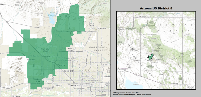
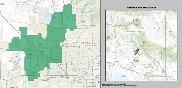
English: Boundaries for Arizona’s 8th United States Federal Congressional District. |
| تاریخ | |
| منبع | GIS shapefile data created by the United States Department of the Interior, as part of the "1 Million Scale" geospatial data project. Retrieved from: http://nationalatlas.gov/atlasftp-1m.html?openChapters=#chpbound |
| پدیدآور | 1: GIS (congressional districts, 2013) shapefile data was created by the United States Department of the Interior. 2: Data was rendered using ArcGIS® software by Esri. 3: File developed for use on Wikipedia and elsewhere by 7partparadigm. |
اجازهنامه
This map was obtained from an edition of the National Atlas of the United States. Like almost all works of the U.S. federal government, works from the National Atlas are in the public domain in the United States.
Online access: NationalAtlas.gov | 1970 print edition: Library of Congress, Perry-Castañeda Library
|
تاریخچهٔ پرونده
روی تاریخ/زمانها کلیک کنید تا نسخهٔ مربوط به آن هنگام را ببینید.
| تاریخ/زمان | بندانگشتی | ابعاد | کاربر | توضیح | |
|---|---|---|---|---|---|
| کنونی | ۱۵ مهٔ ۲۰۱۴، ساعت ۲۱:۲۰ |  | ۲٬۰۷۲ در ۱٬۰۰۸ (۳٫۱۵ مگابایت) | 7partparadigm | User created page with UploadWizard |
کاربرد پرونده
صفحهٔ زیر از این تصویر استفاده میکند:
کاربرد سراسری پرونده
ویکیهای دیگر زیر از این پرونده استفاده میکنند:
- کاربرد در ca.wikipedia.org
- کاربرد در de.wikipedia.org
- کاربرد در en.wikipedia.org
- کاربرد در fr.wikipedia.org
- کاربرد در hu.wikipedia.org
- کاربرد در it.wikipedia.org
- کاربرد در www.wikidata.org