
پرونده:1850 Mitchell Map of Arabia, Persia, Afghanistan - Geographicus - Arabia-mitchell-1850.jpg
پروندهٔ اصلی (۳٬۵۰۰ × ۲٬۸۶۵ پیکسل، اندازهٔ پرونده: ۲٫۷۷ مگابایت، نوع MIME پرونده: image/jpeg)
این پرونده در ویکیانبار موجود است. محتویات صفحهٔ توصیف آن در زیر نمایش داده میشود. |
| این یک نگاره برگزیده است، بدین معنی که اعضای جامعه آن را بهعنوان یکی از نگارههای خوب در ویکیپدیای فارسی شناختهاند. اگر شما نگارهای متفاوت با کیفیت مشابه دارید، مطمئن شوید که آن را با برچسب مجوز آزاد بارگذاری میکنید، به مقالهٔ مرتبط میافزایید و آن را نامزد میکنید. |
| عنوان مقاله |
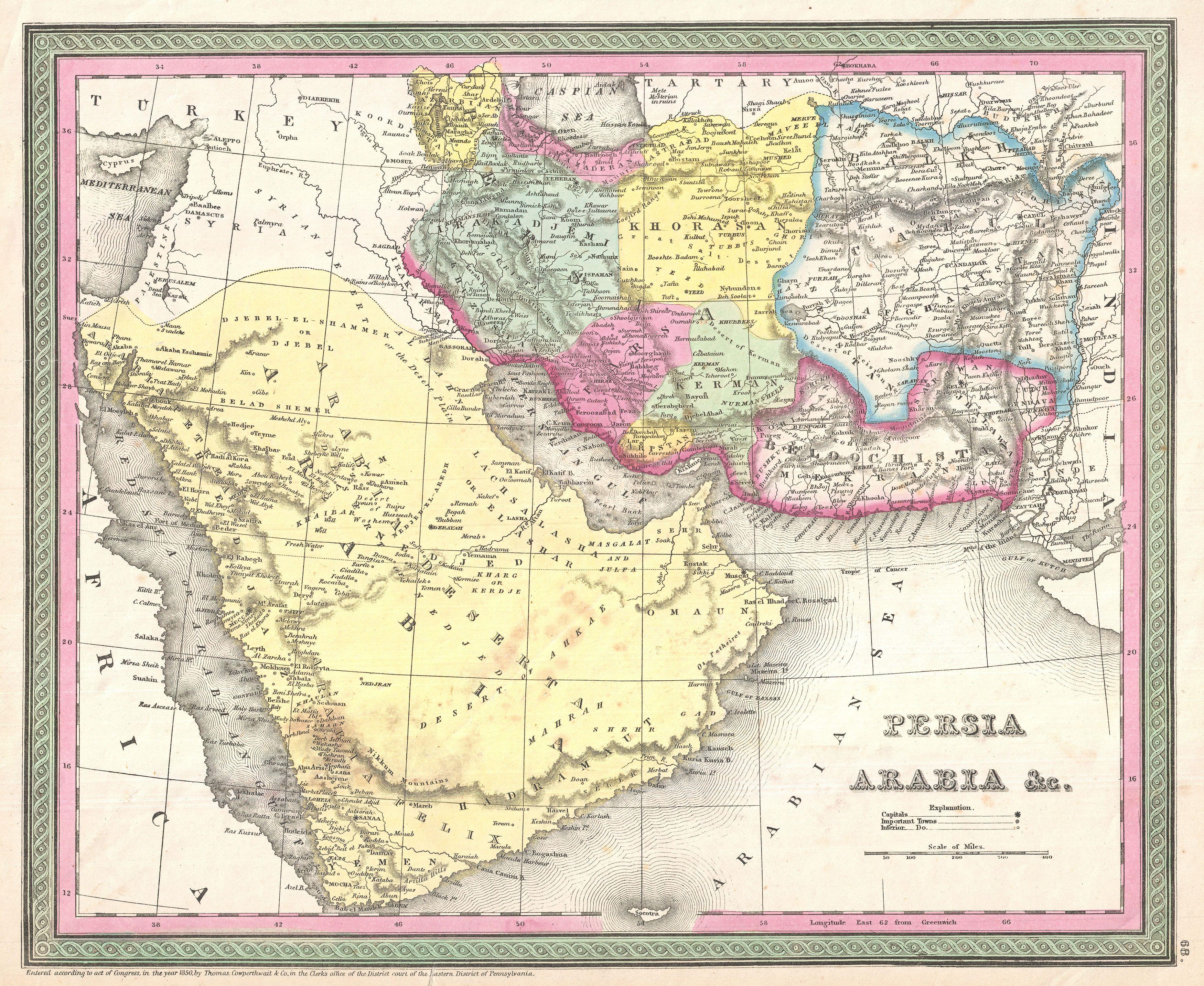
Persia, Arabia & C. |
|||||||||||||||||||
| Description |
English: A fine example of S. A. Mitchell Sr.'s important c. 1850 map of Arabia, Persia, and Afghanistan.
|
|||||||||||||||||||
| تاریخ | (dated) | |||||||||||||||||||
| منبع |
Mitchell Sr., S. A.,A New Universal Atlas Containing Maps of the various Empires, Kingdoms, States and Republics Of The World. (1850 issue)
|
|||||||||||||||||||
| پدیدآورنده |
|
|||||||||||||||||||
| اجازهنامه (استفادهٔ مجدد از این پرونده) |
|
|||||||||||||||||||
| Georeferencing | If inappropriate please set warp_status = skip to hide. | |||||||||||||||||||
| Archival data | ||||||||||||||||||||
| آیدی |
Geographicus link: Arabia-mitchell-1850 |
|||||||||||||||||||
| ابعاد | بلندی: ۱۲٫۵ اینچ (۳۱٫۷ سانتیمتر)؛ عرض: ۱۵٫۵ اینچ (۳۹٫۳ سانتیمتر) | |||||||||||||||||||
| دیگر نسخهها | ||||||||||||||||||||

|
تاریخچهٔ پرونده
روی تاریخ/زمانها کلیک کنید تا نسخهٔ مربوط به آن هنگام را ببینید.
| تاریخ/زمان | بندانگشتی | ابعاد | کاربر | توضیح | |
|---|---|---|---|---|---|
| کنونی | ۲۳ مارس ۲۰۱۱، ساعت ۲۱:۴۵ | | ۳٬۵۰۰ در ۲٬۸۶۵ (۲٫۷۷ مگابایت) | BotMultichillT | {{subst:User:Multichill/Geographicus |link=http://www.geographicus.com/P/AntiqueMap/Arabia-mitchell-1850 |product_name=1850 Mitchell Map of Arabia, Persia, Afghanistan |map_title=Persia, Arabia & C. |description=A fine example of S. A. Mitchell Sr.'s |
کاربرد پرونده
صفحههای زیر از این تصویر استفاده میکنند:
- نقشه خاورمیانه ساموئل آگوستوس میشل
- بحث کاربر:Magic Wizard/بایگانی ۱
- ویکیپدیا:نگاره روز/دسامبر ۲۰۱۴
- ویکیپدیا:نگارههای برگزیده/نقشه
- ویکیپدیا:گزیدن نگاره برگزیده/1850 Mitchell Map of Arabia, Persia, Afghanistan - Geographicus - Arabia-mitchell-1850.jpg
- ویکیپدیا:گزیدن نگاره برگزیده/فوریه-۲۰۱۴
- الگو:نر/2014-12-20
- الگو:نر محافظت شده/2014-12-20
- درگاه:خراسان/نگاره برگزیده
- درگاه:خراسان/نگاره برگزیده/۲۳
کاربرد سراسری پرونده
ویکیهای دیگر زیر از این پرونده استفاده میکنند:
- کاربرد در mzn.wikipedia.org