
پرونده:Interior view of utilidor passageway link between building nos. 101 and 102 showing waveguides on left and cable tray system on right sides. Note fire suppression water supply piping HAER AK-30-A-102.tif

حجم پیشنمایش JPG این TIF file:۷۳۳ × ۶۰۰ پیکسل کیفیتهای دیگر: ۲۹۳ × ۲۴۰ پیکسل | ۵۸۷ × ۴۸۰ پیکسل | ۹۳۹ × ۷۶۸ پیکسل | ۱٬۲۵۱ × ۱٬۰۲۴ پیکسل | ۲٬۵۰۳ × ۲٬۰۴۸ پیکسل | ۵٬۱۷۶ × ۴٬۲۳۶ پیکسل.
پروندهٔ اصلی (۵٬۱۷۶ × ۴٬۲۳۶ پیکسل، اندازهٔ پرونده: ۲۰٫۹۱ مگابایت، نوع MIME پرونده: image/tiff)
این پرونده در ویکیانبار موجود است. محتویات صفحهٔ توصیف آن در زیر نمایش داده میشود. |
خلاصه
| عنوان |
Interior view of utilidor passageway link between building nos. 101 and 102 showing waveguides on left and cable tray system on right sides. Note fire suppression water supply piping (upper center). Small maintenance 3-wheel vehicle at center (Note- similar vehicles still in use in 2001.) Official photograph BMEWS Project by Hansen, Photographic Services, Riverton, NJ, BMEWS, clear as negative no. A-101123. - Clear Air Force Station, Ballistic Missile Early Warning System Site II, One mile west of mile marker 293.5 on Parks Highway, 5 miles southwest of Anderson, Anderson, Denali Borough, AK |
|||
| محل تصویرشده | Alaska; Denali Borough; Anderson | |||
| تکنیک/سبک | 4 x 5 in. | |||
| مکان کنونی |
Library of Congress Prints and Photographs Division Washington, D.C. 20540 USA http://hdl.loc.gov/loc.pnp/pp.print |
|||
| آیدی |
HAER AK-30-A-102 |
|||
| خط اعتبار |
|
|||
| منبع | https://www.loc.gov/pictures/item/ak0486.photos.193587p | |||
| اجازهنامه (استفادهٔ مجدد از این پرونده) |
|

| مختصات دوربین | | محل قرارگیری این نگاره و سایر نگارهها در: نقشهٔ شهری باز |
|---|
تاریخچهٔ پرونده
روی تاریخ/زمانها کلیک کنید تا نسخهٔ مربوط به آن هنگام را ببینید.
| تاریخ/زمان | بندانگشتی | ابعاد | کاربر | توضیح | |
|---|---|---|---|---|---|
| کنونی | ۲۶ ژوئن ۲۰۱۴، ساعت ۲۳:۲۱ | 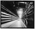 | ۵٬۱۷۶ در ۴٬۲۳۶ (۲۰٫۹۱ مگابایت) | Fæ | GWToolset: Creating mediafile for Fæ. HABS batch upload restart 26 June 2014 (p21:101)x |
کاربرد پرونده
صفحهٔ زیر از این تصویر استفاده میکند:
کاربرد سراسری پرونده
ویکیهای دیگر زیر از این پرونده استفاده میکنند:
- کاربرد در en.wikipedia.org