
پرونده:Plan Odendaal.png
تفکیکپذیری بالاتری در دسترس نیست.
Plan_Odendaal.png (۴۱۸ × ۴۱۸ پیکسل، اندازهٔ پرونده: ۳۳ کیلوبایت، نوع MIME پرونده: image/png)
این پرونده در ویکیانبار موجود است. محتویات صفحهٔ توصیف آن در زیر نمایش داده میشود. |

|
این map نگاره میبایست با استفاده از گرافیک برداری اسویجی فایل بازسازی شوند. این چند مزیت دارد؛ Commons:Media for cleanup را برای اطلاعات بیشتر ببینید. اگر حالت برداری آن در حال حاضر موجود است، لطفاً آن را بار کنید. پس از بارکردن یک اسویجی، این الگو را با {{vector version available|new image name.svg}} جایگزین کنید.
|
خلاصه
| توضیح |
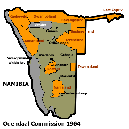
Español: Bantustanes en el territorio de Namibia con Damaraland al noroeste del país
English: This map shows the Odendaal Commission Plan for Namibia of 1964. The plan divided Namibia into Bantustans or Homelands. |
||||||||
| تاریخ | |||||||||
| منبع | |||||||||
| پدیدآور | Bries | ||||||||
| اجازهنامه (استفادهٔ مجدد از این پرونده) |
|
||||||||
| دیگر نسخهها | French version : Image:Plan_Odendaal-fr.png |

تاریخچهٔ پرونده
روی تاریخ/زمانها کلیک کنید تا نسخهٔ مربوط به آن هنگام را ببینید.
| تاریخ/زمان | بندانگشتی | ابعاد | کاربر | توضیح | |
|---|---|---|---|---|---|
| کنونی | ۲۵ نوامبر ۲۰۲۳، ساعت ۲۲:۰۰ | | ۴۱۸ در ۴۱۸ (۳۳ کیلوبایت) | LoomCreek | Transparency |
| ۲۱ آوریل ۲۰۰۵، ساعت ۰۷:۴۰ |  | ۴۱۸ در ۴۱۸ (۱۵ کیلوبایت) | Bries | This map shows the Odendaal Commission Plan for Namibia of 1964. The plan divided Namibia into ''Bantustans'' or ''Homelands''. I have created the map for the Wikipedia community. Category:Maps of Namibia {{GFDL}} |
کاربرد پرونده
صفحهٔ زیر از این تصویر استفاده میکند:
کاربرد سراسری پرونده
ویکیهای دیگر زیر از این پرونده استفاده میکنند:
- کاربرد در af.wikipedia.org
- کاربرد در ar.wikipedia.org
- کاربرد در ast.wikipedia.org
- کاربرد در bn.wikipedia.org
- کاربرد در ca.wikipedia.org
- Bantustan
- Hereros
- Resolució 301 del Consell de Seguretat de les Nacions Unides
- Resolució 309 del Consell de Seguretat de les Nacions Unides
- Resolució 310 del Consell de Seguretat de les Nacions Unides
- Resolució 319 del Consell de Seguretat de les Nacions Unides
- Resolució 323 del Consell de Seguretat de les Nacions Unides
- Resolució 342 del Consell de Seguretat de les Nacions Unides
- Resolució 366 del Consell de Seguretat de les Nacions Unides
- کاربرد در ckb.wikipedia.org
- کاربرد در de.wikipedia.org
- کاربرد در en.wikipedia.org
- South West Africa
- History of Namibia
- Bantustan
- Kaokoland
- Bushmanland (South West Africa)
- Hereroland
- Ovamboland
- Damaraland
- Tswanaland
- Kavangoland
- Rehoboth (homeland)
- Namaland
- East Caprivi
- Fox Odendaal
- Diocese of Namibia
- United Nations Security Council Resolution 301
- Land reform in Namibia
- Aminuis
- Constance Kgosiemang
- کاربرد در es.wikipedia.org
نمایش استفادههای سراسری از این پرونده.