
پرونده:Old map 1807 plan.jpg
پروندهٔ اصلی (۱٬۰۰۴ × ۱٬۱۹۲ پیکسل، اندازهٔ پرونده: ۵۱۹ کیلوبایت، نوع MIME پرونده: image/jpeg)
این پرونده در ویکیانبار موجود است. محتویات صفحهٔ توصیف آن در زیر نمایش داده میشود. |
خلاصه
| توضیح |
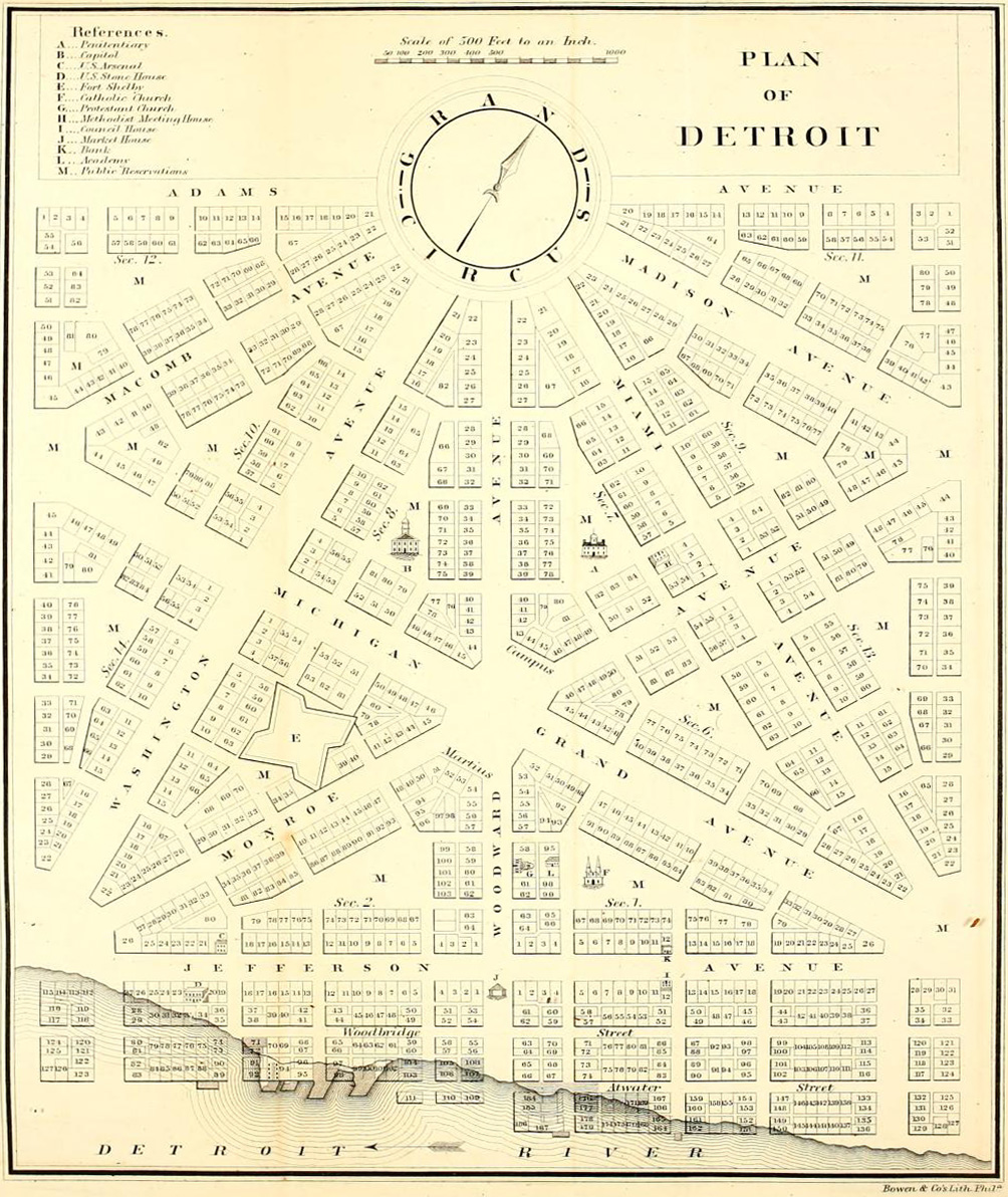
English: Detroit city layout plan circa 1807—following the 1805 fire that destroyed most of the city. The map shows Grand Circus Park (top), and some of the present-day Grand Circus Park Historic District. |
| تاریخ | حوالی ۱۸۰۷ |
| منبع | Dickens, Asbury & Forney, John W., eds. (1832) "Plan of Detroit" (Map). American State Papers. Vol. 6: Public Lands. 1:6,000. Washington, DC: Gales & Seaton. p. 299. OCLC 2053058. OL7014594M. LCCN 09033892. – via Archive.org. |
| پدیدآور | نامعلوم |
اجازهنامه
This image is in the public domain because it is a mere mechanical scan or photocopy of a public domain original, or – from the available evidence – is so similar to such a scan or photocopy that no copyright protection can be expected to arise. The original itself is in the public domain for the following reason:
This tag is designed for use where there may be a need to assert that any enhancements (eg brightness, contrast, colour-matching, sharpening) are in themselves insufficiently creative to generate a new copyright. It can be used where it is unknown whether any enhancements have been made, as well as when the enhancements are clear but insufficient. For known raw unenhanced scans you can use an appropriate {{PD-old}} tag instead. For usage, see Commons:When to use the PD-scan tag.  |


تاریخچهٔ پرونده
روی تاریخ/زمانها کلیک کنید تا نسخهٔ مربوط به آن هنگام را ببینید.
| تاریخ/زمان | بندانگشتی | ابعاد | کاربر | توضیح | |
|---|---|---|---|---|---|
| کنونی | ۴ آوریل ۲۰۱۳، ساعت ۰۵:۱۸ | | ۱٬۰۰۴ در ۱٬۱۹۲ (۵۱۹ کیلوبایت) | Imzadi1979 | perspective correction and cropped to remove whitespace |
| ۲۲ سپتامبر ۲۰۱۲، ساعت ۱۶:۴۶ |  | ۱٬۱۱۵ در ۱٬۳۴۸ (۲۶۰ کیلوبایت) | Imzadi1979 | higher resolution version with known source information | |
| ۸ ژوئیهٔ ۲۰۰۷، ساعت ۱۴:۵۴ |  | ۶۵۵ در ۹۳۷ (۱۴۶ کیلوبایت) | DeltaWeb~commonswiki | == Summary == Detroit city layout circa 1807 following the 1805 fire that destroyed most of the city. From the Detroit Historical Museum site == Licensing == {{PD-US}} Category:Michigan maps Category:Images of Detroit, Michigan [[Category:Images |
کاربرد پرونده
صفحهٔ زیر از این تصویر استفاده میکند:
کاربرد سراسری پرونده
ویکیهای دیگر زیر از این پرونده استفاده میکنند:
- کاربرد در ar.wikipedia.org
- کاربرد در en.wikipedia.org
- M-1 (Michigan highway)
- Campus Martius Park
- History of Detroit
- Augustus B. Woodward
- Grand Circus Park Historic District
- Gabriel Richard
- Washington Boulevard Historic District
- Roads and freeways in metropolitan Detroit
- National Register of Historic Places listings in Detroit
- Transportation in metropolitan Detroit
- User:Andrew Jameson/Detroit2
- User:Andrew Jameson/Detroit1
- National Register of Historic Places listings in Downtown and Midtown Detroit
- File talk:Old map 1807 plan.jpg
- Great Fire of 1805
- کاربرد در es.wikipedia.org
- کاربرد در fr.wikipedia.org
- کاربرد در gl.wikipedia.org
- کاربرد در ru.wikipedia.org