
پرونده:Map of the Arctic region showing the Northeast Passage, the Northern Sea Route and Northwest Passage, and bathymetry.png

اندازهٔ این پیشنمایش: ۶۳۲ × ۶۰۰ پیکسل. کیفیتهای دیگر: ۲۵۳ × ۲۴۰ پیکسل | ۵۰۶ × ۴۸۰ پیکسل | ۱٬۰۰۳ × ۹۵۲ پیکسل.
پروندهٔ اصلی (۱٬۰۰۳ × ۹۵۲ پیکسل، اندازهٔ پرونده: ۷۵۸ کیلوبایت، نوع MIME پرونده: image/png)
این پرونده در ویکیانبار موجود است. محتویات صفحهٔ توصیف آن در زیر نمایش داده میشود. |
خلاصه
| توضیح |
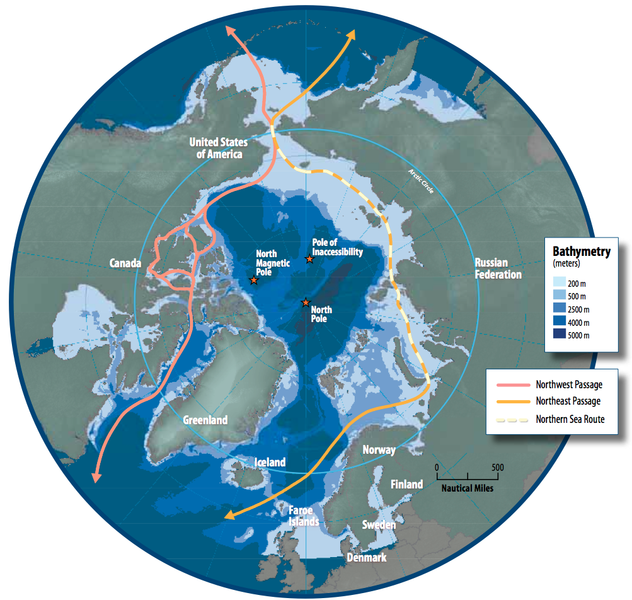
English: Map of the Arctic region showing shipping routes Northeast Passage, Northern Sea Route, and Northwest Passage, and bathymetry |
| تاریخ | |
| منبع | Arctic Council - Arctic marine shipping assessment - http://www.arctic.noaa.gov/detect/documents/AMSA_2009_Report_2nd_print.pdf |
| پدیدآور | Susie Harder |
اجازهنامه
This file is in the public domain because the work was created/published by the Arctic Council, an international organization
|
تاریخچهٔ پرونده
روی تاریخ/زمانها کلیک کنید تا نسخهٔ مربوط به آن هنگام را ببینید.
| تاریخ/زمان | بندانگشتی | ابعاد | کاربر | توضیح | |
|---|---|---|---|---|---|
| کنونی | ۱۹ اکتبر ۲۰۱۴، ساعت ۱۶:۴۶ | | ۱٬۰۰۳ در ۹۵۲ (۷۵۸ کیلوبایت) | Al83tito | User created page with UploadWizard |
کاربرد پرونده
صفحههای زیر از این تصویر استفاده میکنند:
کاربرد سراسری پرونده
ویکیهای دیگر زیر از این پرونده استفاده میکنند:
- کاربرد در bn.wikipedia.org
- کاربرد در de.wikipedia.org
- کاربرد در en.wikipedia.org
- کاربرد در es.wikipedia.org
- کاربرد در fr.wikipedia.org
- کاربرد در he.wikipedia.org
- کاربرد در hr.wikipedia.org
- کاربرد در hu.wikipedia.org
- کاربرد در id.wikipedia.org
- کاربرد در it.wikipedia.org
- کاربرد در ja.wikipedia.org
- کاربرد در ko.wikipedia.org
- کاربرد در nl.wikipedia.org
- کاربرد در pl.wikipedia.org
- کاربرد در pt.wikipedia.org
- کاربرد در ru.wikipedia.org
- کاربرد در sd.wikipedia.org
- کاربرد در te.wikipedia.org
- کاربرد در th.wikipedia.org
- کاربرد در tr.wikipedia.org