
پرونده:Kingdom of Hungary counties-2.svg

حجم پیشنمایش PNG این SVG file:۷۷۹ × ۵۱۳ پیکسل کیفیتهای دیگر: ۳۲۰ × ۲۱۱ پیکسل | ۶۴۰ × ۴۲۱ پیکسل | ۱٬۰۲۴ × ۶۷۴ پیکسل | ۱٬۲۸۰ × ۸۴۳ پیکسل | ۲٬۵۶۰ × ۱٬۶۸۶ پیکسل.
پروندهٔ اصلی (پروندهٔ اسویجی، با ابعاد ۷۷۹ × ۵۱۳ پیکسل، اندازهٔ پرونده: ۲۶۵ کیلوبایت)
این پرونده در ویکیانبار موجود است. محتویات صفحهٔ توصیف آن در زیر نمایش داده میشود. |
| توضیح |
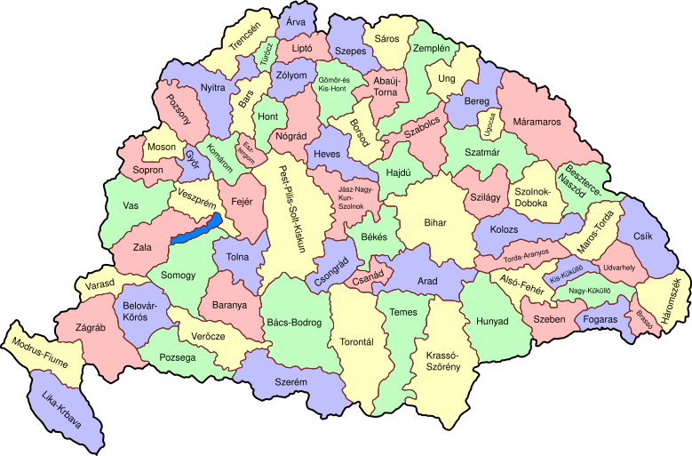
Map of counties of Kingdom of Hungary (Hungary proper and Croatia & Slavonia), 1886-1918. I have organised this into layers: Three layers of paths for the counties, for the county borders, and for external border. and one layer for the text labels. I have added basic styles and classified all elements. I have given all elements reasonable IDs the counties (the county name) and the borders (the names of the counties on each side) and the text labels (the names of the counties, with underscores indicating where they are split across labels). The counties are classed into four styles to make a four colour map, of course the colours can be changed just by changing the style (there as a fifth style for Lake Balaton, which does not show up very well on tis uploaded one). The main thing now is to fix the text styles. |
||
| تاریخ | (UTC) | ||
| منبع | |||
| پدیدآور |
|
||
| دیگر نسخهها |
|

| این یک عکس دستکاری شده است به این معنی که به صورت دیجیتالی از نسخهٔ اصلی تغییر یافتهاست. تغییرها: As described - added more useful metadata and structure. اصل آن را میتوان در اینجا مشاهده کرد: Kingdom of Hungary counties.svg. تغییرها توسط SimonTrew انجام شدهاست.
|
من، صاحب حقوق قانونی این اثر، به این وسیله این اثر را تحث اجازهنامهٔ ذیل منتشر میکنم:
| من، دارنده حق تکثیر این اثر، این اثر را به مالکیت عمومی منتشر میکنم. این قابل اجرا در تمام نقاط جهان است. در برخی از کشورها ممکن است به صورت قانونی این امکانپذیر نباشد؛ اگر چنین است: من اجازهٔ استفاده از این اثر را برای هر مقصودی، بدون هیچگونه شرایطی میدهم، تا وقتی که این شرایط توسط قانون مستلزم نشده باشد. |
سیاهه بارگذاری اصلی
This image is a derivative work of the following images:
- File:Kingdom_of_Hungary_counties.svg licensed with PD-self
- 2007-08-20T20:25:30Z Xavax 779x513 (240591 Bytes) == Summary == {{Information| |Description= Map of counties of Hungary with Croatia & Slavonia, 1886-1918 |Source=own drawing |Date=April 30, 2006 |Author=[[User:IMeowbot]] |Permission= |other_versions= }} == Licensing == {{P
- 2006-04-30T22:10:47Z IMeowbot 779x513 (228524 Bytes) line weight
- 2006-04-30T21:34:49Z IMeowbot 779x513 (225942 Bytes)
- 2006-04-30T18:34:30Z IMeowbot 779x513 (199213 Bytes) {{Information| |Description= Map of late 1870s Hungary counties |Source=own drawing |Date=April 30, 2006 |Author=[[User:IMeowbot]] |Permission= |other_versions= }}
Uploaded with derivativeFX
تاریخچهٔ پرونده
روی تاریخ/زمانها کلیک کنید تا نسخهٔ مربوط به آن هنگام را ببینید.
| تاریخ/زمان | بندانگشتی | ابعاد | کاربر | توضیح | |
|---|---|---|---|---|---|
| کنونی | ۵ دسامبر ۲۰۰۹، ساعت ۱۷:۵۷ | | ۷۷۹ در ۵۱۳ (۲۶۵ کیلوبایت) | SimonTrew | I missed some fixes of Veszprém |
| ۵ دسامبر ۲۰۰۹، ساعت ۱۷:۵۵ |  | ۷۷۹ در ۵۱۳ (۲۶۵ کیلوبایت) | SimonTrew | Fix spelling of Vesprém, as I have just done on original. | |
| ۳ دسامبر ۲۰۰۹، ساعت ۱۴:۲۹ |  | ۷۷۹ در ۵۱۳ (۲۶۵ کیلوبایت) | SimonTrew | Fix spelling of Pozsony, as I have just done on original work | |
| ۳ دسامبر ۲۰۰۹، ساعت ۱۳:۳۷ |  | ۷۷۹ در ۵۱۳ (۲۶۵ کیلوبایت) | SimonTrew | Made four colour map. The text still only uses one style at the moment, this needs to be made to match the four styles used for the four colours for the counties, but this is easier to do once it is uploaded and I can print the png. Sorry if this is "not | |
| ۳ دسامبر ۲۰۰۹، ساعت ۱۱:۲۹ |  | ۷۷۹ در ۵۱۳ (۲۸۷ کیلوبایت) | SimonTrew | Fixed the few errors in borders, removed unnecessary style fields from text (Inkscape adds them but they are covered by other fields), text still needs doing better | |
| ۳ دسامبر ۲۰۰۹، ساعت ۰۱:۱۶ |  | ۷۷۹ در ۵۱۳ (۲۸۶ کیلوبایت) | SimonTrew | {{Information |Description=Map of counties of Kingdom of Hungary (Hungary proper and Croatia & Slavonia), 1886-1918. I have organised this into layers: Three layers of paths for the counties, for the county borders, and for external border. and one layer |
کاربرد پرونده
صفحهٔ زیر از این تصویر استفاده میکند:
کاربرد سراسری پرونده
ویکیهای دیگر زیر از این پرونده استفاده میکنند:
- کاربرد در ar.wikipedia.org
- کاربرد در bs.wikipedia.org
- کاربرد در ceb.wikipedia.org
- کاربرد در ckb.wikipedia.org
- کاربرد در da.wikipedia.org
- کاربرد در de.wikipedia.org
- کاربرد در en.wikipedia.org
- User talk:Random user 8384993
- Wikipedia talk:WikiProject Hungary/Archive 2
- Module:Location map/data/Kingdom of Hungary/doc
- Wikipedia:Redirects for discussion/Log/2015 April 19
- User:Drkazmer/Jewish centres in the Kingdom of Hungary
- Wikipedia:Graphics Lab/Map workshop/Archive/2017/Sep 2017
- Module:Location map/data/Kingdom of Hungary
- کاربرد در fr.wikipedia.org
- کاربرد در hu.wikipedia.org
- کاربرد در kn.wikipedia.org
- کاربرد در pt.wikipedia.org
- کاربرد در rue.wikipedia.org
- کاربرد در si.wikipedia.org
- کاربرد در sr.wikipedia.org
- کاربرد در tg.wikipedia.org
- کاربرد در tr.wikipedia.org
- کاربرد در uz.wikipedia.org
- کاربرد در war.wikipedia.org