
پرونده:Athabasca Oil Sands map.png

اندازهٔ این پیشنمایش: ۴۱۰ × ۵۹۹ پیکسل. کیفیتهای دیگر: ۱۶۴ × ۲۴۰ پیکسل | ۳۲۸ × ۴۸۰ پیکسل | ۵۲۶ × ۷۶۸ پیکسل | ۱٬۲۰۰ × ۱٬۷۵۳ پیکسل.
پروندهٔ اصلی (۱٬۲۰۰ × ۱٬۷۵۳ پیکسل، اندازهٔ پرونده: ۶۱۱ کیلوبایت، نوع MIME پرونده: image/png)
این پرونده در ویکیانبار موجود است. محتویات صفحهٔ توصیف آن در زیر نمایش داده میشود. |
خلاصه
| توضیح |
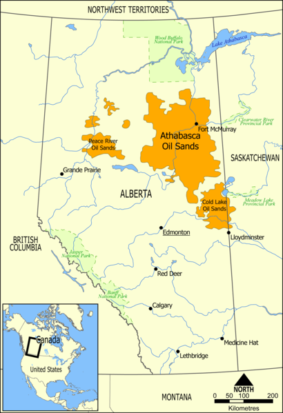
English: This map shows the extent of the oil sands in Alberta, Canada. The three oil sand deposits are known as the Athabasca Oil Sands, the Cold Lake Oil Sands, and the Peace River Oil Sands. |
| تاریخ | |
| منبع | اثر شخصی |
| پدیدآور | NormanEinstein |
| دیگر نسخهها |
آثار انشقاقی از این پرونده: Athabasca oil sand mining map 2011.jpg: |
اجازهنامه
| من، دارنده حق تکثیر این اثر، این اثر را به مالکیت عمومی منتشر میکنم. این قابل اجرا در تمام نقاط جهان است. در برخی از کشورها ممکن است به صورت قانونی این امکانپذیر نباشد؛ اگر چنین است: من اجازهٔ استفاده از این اثر را برای هر مقصودی، بدون هیچگونه شرایطی میدهم، تا وقتی که این شرایط توسط قانون مستلزم نشده باشد. |
تاریخچهٔ پرونده
روی تاریخ/زمانها کلیک کنید تا نسخهٔ مربوط به آن هنگام را ببینید.
| تاریخ/زمان | بندانگشتی | ابعاد | کاربر | توضیح | |
|---|---|---|---|---|---|
| کنونی | ۱۰ مهٔ ۲۰۰۶، ساعت ۱۶:۴۹ | | ۱٬۲۰۰ در ۱٬۷۵۳ (۶۱۱ کیلوبایت) | NormanEinstein | This map shows the extent of the oils sands in Alberta, Canada. The three oil sand deposits are known as the Athabasca Oil Sands, the Cold Lake Oil Sands, and the Peace River Oil Sands. Created by NormanEinstein, May 10, 2006. {{GFDL-self}} [[Category: |
کاربرد پرونده
صفحهٔ زیر از این تصویر استفاده میکند:
کاربرد سراسری پرونده
ویکیهای دیگر زیر از این پرونده استفاده میکنند:
- کاربرد در ar.wikipedia.org
- کاربرد در bg.wikipedia.org
- کاربرد در ca.wikipedia.org
- کاربرد در cs.wikipedia.org
- کاربرد در da.wikipedia.org
- کاربرد در de.wikipedia.org
- کاربرد در el.wikipedia.org
- کاربرد در en.wikipedia.org
- Ernest Manning
- Oil sands
- Athabasca oil sands
- User:NormanEinstein/gallery
- Template:Text-superimpose
- Wabasca oil field
- History of the petroleum industry in Canada (oil sands and heavy oil)
- Kearl Oil Sands Project
- Cold Lake oil sands
- Peace River oil sands
- Oil sands tailings ponds (Canada)
- Tar Sands Healing Walk
- User:Klausronjaen/sandbox
- Georg Naumann
- User:Garrett.Nielsen/sandbox
- Environmental issues in Alberta
- Timeline of the petroleum industry in Alberta
- Template:Text-superimpose/doc
- Template:Text-superimpose/sandbox
- History of the Petroleum industry in Alberta
- Legacy pollution
- User:Spencerladner/Legacy pollution
- کاربرد در en.wikinews.org
- کاربرد در es.wikipedia.org
- کاربرد در fi.wikipedia.org
- کاربرد در fr.wikipedia.org
- کاربرد در gl.wikipedia.org
- کاربرد در he.wikipedia.org
- کاربرد در it.wikipedia.org
- کاربرد در ja.wikipedia.org
نمایش استفادههای سراسری از این پرونده.