
پرونده:United States House of Representatives, West Virginia District 1 map.png
تفکیکپذیری بالاتری در دسترس نیست.
United_States_House_of_Representatives,_West_Virginia_District_1_map.png (۶۳۵ × ۳۷۹ پیکسل، اندازهٔ پرونده: ۲۸ کیلوبایت، نوع MIME پرونده: image/png)
این پرونده در ویکیانبار موجود است. محتویات صفحهٔ توصیف آن در زیر نمایش داده میشود. |
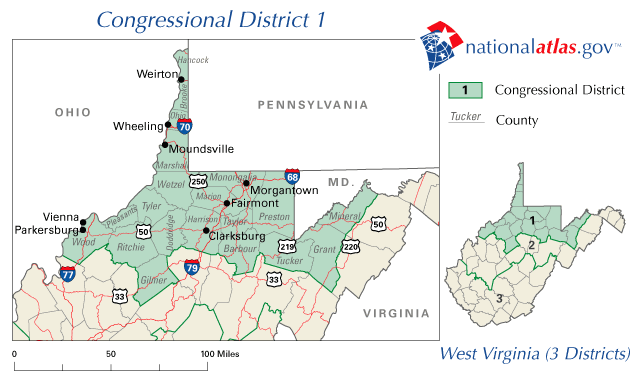
A map of United States House of Representatives, West Virginia District 1.
The map is from nationalatlas.gov, specifically WV01_109.gif.
This map was obtained from an edition of the National Atlas of the United States. Like almost all works of the U.S. federal government, works from the National Atlas are in the public domain in the United States.
Online access: NationalAtlas.gov | 1970 print edition: Library of Congress, Perry-Castañeda Library
|
تاریخچهٔ پرونده
روی تاریخ/زمانها کلیک کنید تا نسخهٔ مربوط به آن هنگام را ببینید.
| تاریخ/زمان | بندانگشتی | ابعاد | کاربر | توضیح | |
|---|---|---|---|---|---|
| کنونی | ۳۱ مارس ۲۰۰۶، ساعت ۲۱:۰۶ | | ۶۳۵ در ۳۷۹ (۲۸ کیلوبایت) | Dbenbenn | PD-USGov-Atlas |
کاربرد پرونده
صفحهٔ زیر از این تصویر استفاده میکند:
کاربرد سراسری پرونده
ویکیهای دیگر زیر از این پرونده استفاده میکنند:
- کاربرد در en.wikipedia.org
- West Virginia's 1st congressional district
- 2008 United States House of Representatives elections in West Virginia
- 2010 United States House of Representatives elections in West Virginia
- 2006 United States House of Representatives elections in West Virginia
- 2004 United States House of Representatives elections in West Virginia
- 2002 United States House of Representatives elections in West Virginia