
پرونده:US wind power map.png
اندازهٔ این پیشنمایش: ۸۰۰ × ۵۰۵ پیکسل. کیفیتهای دیگر: ۳۲۰ × ۲۰۲ پیکسل | ۶۴۰ × ۴۰۴ پیکسل | ۱٬۱۳۰ × ۷۱۳ پیکسل.
پروندهٔ اصلی (۱٬۱۳۰ × ۷۱۳ پیکسل، اندازهٔ پرونده: ۱۶۳ کیلوبایت، نوع MIME پرونده: image/png)
این پرونده در ویکیانبار موجود است. محتویات صفحهٔ توصیف آن در زیر نمایش داده میشود. |
خلاصه
| توضیح |
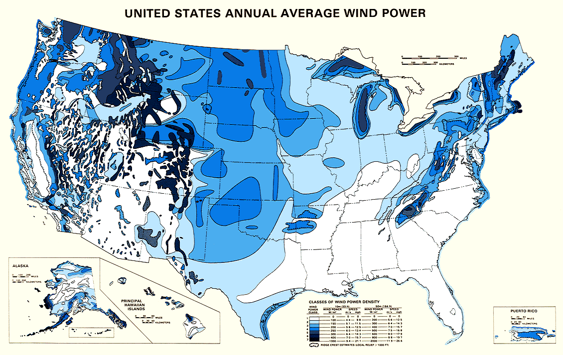
English: Map showing estimated wind resources for the United States. |
| تاریخ | |
| منبع | http://rredc.nrel.gov/wind/pubs/atlas/maps/chap2/2-01m.html |
| پدیدآور | National Renewable Energy Laboratory |
| اجازهنامه (استفادهٔ مجدد از این پرونده) |
EERE copyright policy says its works are public domain: http://www1.eere.energy.gov/webpolicies/#copyright |
| دیگر نسخهها | an updated version of this map, also showing transmission lines, is in: File:United States Wind Resources and Transmission Lines map.jpg |
- 'Source: English Wikipedia, original upload 5 November 2004 by Iain.mcclatchie en:Image:US wind power map.png
اجازهنامه
| This image is a work of a United States Department of Energy (or predecessor organization) employee, taken or made as part of that person's official duties. As a work of the U.S. federal government, the image is in the public domain.
Please note that national laboratories operate under varying licences and some are not free. Check the site policies of any national lab before crediting it with this tag.
|

|
تاریخچهٔ پرونده
روی تاریخ/زمانها کلیک کنید تا نسخهٔ مربوط به آن هنگام را ببینید.
| تاریخ/زمان | بندانگشتی | ابعاد | کاربر | توضیح | |
|---|---|---|---|---|---|
| کنونی | ۴ دسامبر ۲۰۰۵، ساعت ۱۸:۱۲ | | ۱٬۱۳۰ در ۷۱۳ (۱۶۳ کیلوبایت) | Saperaud~commonswiki | *'''Description:''' U.S. wind power map. Source: United States National Renewable Energy Laboratory [http://rredc.nrel.gov/wind/pubs/atlas/maps/chap2/2-01m.html] *''''Source:''' English Wikipedia, original upload 5 November 2004 by [[:en:User:Iain.mcclat |
کاربرد پرونده
صفحهٔ زیر از این تصویر استفاده میکند:
کاربرد سراسری پرونده
ویکیهای دیگر زیر از این پرونده استفاده میکنند:
- کاربرد در fr.wikipedia.org
- کاربرد در fr.wikibooks.org
- کاربرد در he.wikipedia.org
- کاربرد در ht.wikipedia.org
- کاربرد در ja.wikipedia.org
- کاربرد در ru.wikipedia.org