
پرونده:USACE Mansfield Hollow Lake.jpg
اندازهٔ این پیشنمایش: ۷۴۸ × ۶۰۰ پیکسل. کیفیتهای دیگر: ۲۹۹ × ۲۴۰ پیکسل | ۵۹۹ × ۴۸۰ پیکسل | ۹۵۸ × ۷۶۸ پیکسل | ۱٬۲۷۷ × ۱٬۰۲۴ پیکسل | ۱٬۵۰۰ × ۱٬۲۰۳ پیکسل.
پروندهٔ اصلی (۱٬۵۰۰ × ۱٬۲۰۳ پیکسل، اندازهٔ پرونده: ۱٫۵۳ مگابایت، نوع MIME پرونده: image/jpeg)
این پرونده در ویکیانبار موجود است. محتویات صفحهٔ توصیف آن در زیر نمایش داده میشود. |
|
This is an image of a place or building that is listed on the National Register of Historic Places in the United States of America. Its reference number is 3000194. |
| توضیح |
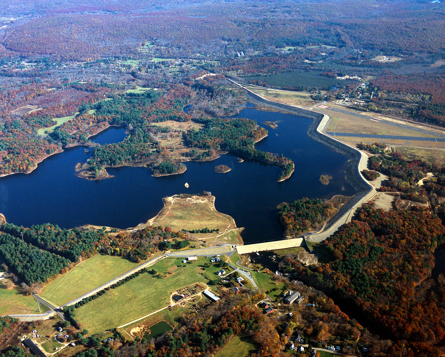
English: Mansfield Hollow Lake in Tolland County, Mansfield, Connecticut, USA. The U.S. Army Corps of Engineers constructed the dam as a flood control measure. It impounds the waters of the Fenton, Mount Hope, and Natchaug Rivers. |
|||
| تاریخ | ۱۰ آوریل ۱۹۹۹ (Date as given in the description, but the date seems unlikely given the autumn color in the landscape.) | |||
| منبع |
U.S. Army Corps of Engineers Digital Visual Library Image page Image description page Digital Visual Library home page |
|||
| پدیدآور | U.S. Army Corps of Engineers, photographer not specified or unknown | |||
| اجازهنامه (استفادهٔ مجدد از این پرونده) |
|
| مختصات دوربین | | محل قرارگیری این نگاره و سایر نگارهها در: نقشهٔ شهری باز |
|---|
تاریخچهٔ پرونده
روی تاریخ/زمانها کلیک کنید تا نسخهٔ مربوط به آن هنگام را ببینید.
| تاریخ/زمان | بندانگشتی | ابعاد | کاربر | توضیح | |
|---|---|---|---|---|---|
| کنونی | ۴ ژوئن ۲۰۰۷، ساعت ۰۵:۰۴ | | ۱٬۵۰۰ در ۱٬۲۰۳ (۱٫۵۳ مگابایت) | Grendelkhan | {{Information | Description = {{en|Mansfield Hollow Lake in Windham County, Connecticut, USA. The U.S. Army Corps of Engineers constructed the dam as a flood control measure. It impounds the waters of the Natchaug River.}} | Source = U.S. Army |
کاربرد پرونده
صفحهٔ زیر از این تصویر استفاده میکند:
کاربرد سراسری پرونده
ویکیهای دیگر زیر از این پرونده استفاده میکنند:
- کاربرد در ceb.wikipedia.org
- کاربرد در de.wikipedia.org
- کاربرد در en.wikipedia.org
- Mansfield, Connecticut
- List of Connecticut state parks
- National Register of Historic Places listings in Tolland County, Connecticut
- National Register of Historic Places listings in Windham County, Connecticut
- Mansfield Hollow Lake
- Portal:Geography/Featured picture/2007, week 40
- Portal:Geography/Featured picture archive/2007
- Wikipedia:WikiProject Lakes/Galleries/11
- Mansfield Hollow State Park
- کاربرد در pl.wikipedia.org
- کاربرد در sv.wikipedia.org
- کاربرد در www.wikidata.org