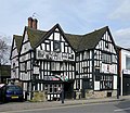
پرونده:The Greyhound and Punchbowl in Bilston, Wolverhampton - geograph.org.uk - 1796318.jpg

Page contents not supported in other languages.
از ویکی‌پدیا، دانشنامهٔ آزاد

The_Greyhound_and_Punchbowl_in_Bilston,_Wolverhampton_-_geograph.org.uk_-_1796318.jpg(۶۴۰ × ۵۵۳ پیکسل، اندازهٔ پرونده: ۱۵۲ کیلوبایت، نوع MIME پرونده: image/jpeg)

This is a photo of listed building number 1201819.

خلاصه

توضیح
English: The Greyhound and Punchbowl in Bilston, Wolverhampton, near to Bilston, Wolverhampton, Great Britain.

This Grade II* listed mid 16th century building (with earlier origins) is in Bilston High Street. At present it seems that draping huge banners about television and breakfasts <a title="https://www.geograph.org.uk/photo/1796324" rel="nofollow" href="https://www.geograph.org.uk/photo/1796324">Link</a><img style="padding-left:2px;" alt="External link" title="External link - shift click to open in new window" src="http://s0.geograph.org.uk/img/external.png" width="10" height="10"/> across this listed building is being tolerated. The owners must have no regard whatsoever for the appearance of what they have got. I shall add more details soon, including comment on whether the service inside reflects the attitude towards the outside.

An image of the house, and many details, without brash commercial graffiti coverings can be seen on the local history website here: <a title="http://www.localhistory.scit.wlv.ac.uk/listed/greyhound/bilstongreyhound.htm" rel="nofollow" href="http://www.localhistory.scit.wlv.ac.uk/listed/greyhound/bilstongreyhound.htm">Link</a><img style="padding-left:2px;" alt="External link" title="External link - shift click to open in new window" src="http://s0.geograph.org.uk/img/external.png" width="10" height="10"/>
تاریخ
منبع From geograph.org.uk; transferred by User:Skinsmoke using geograph_org2commons.
پدیدآور Roger Kidd
اجازه‌نامه
(استفادهٔ مجدد از این پرونده)
Creative Commons Attribution Share-alike license 2.0
انتساب
(required by the license)
InfoField
Roger Kidd / The Greyhound and Punchbowl in Bilston, Wolverhampton / 
Roger Kidd / The Greyhound and Punchbowl in Bilston, Wolverhampton
مختصات دوربین۵۲° ۳۳′ ۴۹٫۶۵″ N, ۲° ۰۴′ ۵۱٫۰۳″ W  Heading=22° Kartographer map based on OpenStreetMap.محل قرارگیری این نگاره و سایر نگاره‌ها در: نقشهٔ شهری بازinfo
مختصات شیء۵۲° ۳۳′ ۵۰″ N, ۲° ۰۴′ ۵۱″ W  Heading=22° Kartographer map based on OpenStreetMap.محل قرارگیری این نگاره و سایر نگاره‌ها در: نقشهٔ شهری بازinfo

اجازه‌نامه

w:fa:کرییتیو کامنز
انتساب انتشار مشابه
این پرونده با اجازه‌نامهٔ کریتیو کامانز Attribution-Share Alike 2.0 عمومی منتشر شده است.
انتساب: Roger Kidd
شما اجازه دارید:
  • برای به اشتراک گذاشتن – برای کپی، توزیع و انتقال اثر
  • تلفیق کردن – برای انطباق اثر
تحت شرایط زیر:
  • انتساب – شما باید اعتبار مربوطه را به دست آورید، پیوندی به مجوز ارائه دهید و نشان دهید که آیا تغییرات ایجاد شده‌اند یا خیر. شما ممکن است این کار را به هر روش منطقی انجام دهید، اما نه به هر شیوه‌ای که پیشنهاد می‌کند که مجوزدهنده از شما یا استفاده‌تان حمایت کند.
  • انتشار مشابه – اگر این اثر را تلفیق یا تبدیل می‌کنید، یا بر پایه‌ آن اثری دیگر خلق می‌کنید، می‌‌بایست مشارکت‌های خود را تحت مجوز یکسان یا مشابه با ا اصل آن توزیع کنید.

عنوان

شرحی یک‌خطی از محتوای این فایل اضافه کنید

آیتم‌هایی که در این پرونده نمایش داده شده‌اند

توصیف‌ها

این خصوصیت مقداری دارد اما نامشخص است.

52°33'49.651"N, 2°4'51.035"W

heading انگلیسی: ۲۲ درجه

52°33'50.123"N, 2°4'50.628"W

heading انگلیسی: ۲۲ درجه

تاریخچهٔ پرونده

روی تاریخ/زمان‌ها کلیک کنید تا نسخهٔ مربوط به آن هنگام را ببینید.

تاریخ/زمانبندانگشتیابعادکاربرتوضیح
کنونی‏۲۹ ژوئیهٔ ۲۰۱۰، ساعت ۱۶:۵۷تصویر بندانگشتی از نسخهٔ مورخ ‏۲۹ ژوئیهٔ ۲۰۱۰، ساعت ۱۶:۵۷۶۴۰ در ۵۵۳ (۱۵۲ کیلوبایت)File Upload Bot (Magnus Manske)== {{int:filedesc}} == {{Information |Description={{en|1=The Greyhound and Punchbowl in Bilston, Wolverhampton, near to Bilston, Wolverhampton, Great Britain. This Grade II* listed mid 16th century building (with earlier origins) is in Bilston High Street

صفحهٔ زیر از این تصویر استفاده می‌کند:

کاربرد سراسری پرونده

ویکی‌های دیگر زیر از این پرونده استفاده می‌کنند:

فراداده