
پرونده:Tarso Toh.jpg
تفکیکپذیری بالاتری در دسترس نیست.
Tarso_Toh.jpg (۶۴۰ × ۴۵۸ پیکسل، اندازهٔ پرونده: ۱۶۴ کیلوبایت، نوع MIME پرونده: image/jpeg)
این پرونده در ویکیانبار موجود است. محتویات صفحهٔ توصیف آن در زیر نمایش داده میشود. |
خلاصه
| توضیح |
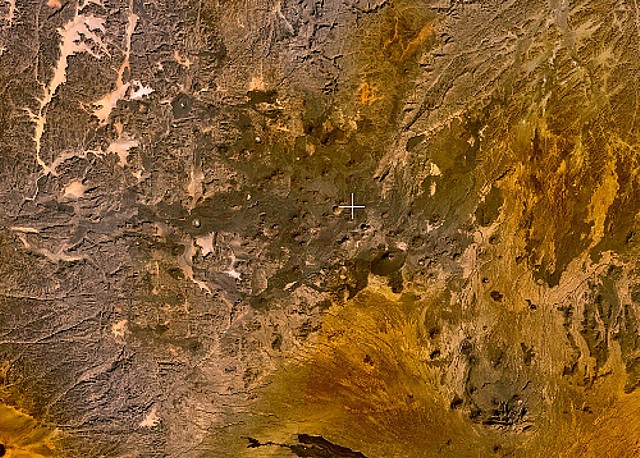
English: Small cinder cones and lava flows of the Tarso Tôh volcanic field can be seen in the large darker-brownish area at the center of this NASA Landsat image. This Pleistocene-to-Holocene volcanic field in the Tibesti Range of Chad covers a 30 x 80 km area and contains 150 scoria cones and two maars. Basaltic lava flows at Tarso Tôh were erupted over a basement of Precambrian schists and Paleozoic sandstones. The black lava flows at the very bottom-center are distal lava flows from Tarso Toussidé volcano. |
| تاریخ | تاریخ نامعلوم |
| منبع | http://www.volcano.si.edu/world/volcano.cfm?vnum=0205-009&volpage=photos&photo=119033 |
| پدیدآور | NASA Landsat7 image (worldwind.arc.nasa.gov) |
اجازهنامه
| این تصویر در مالکیت عمومی قرار دارد به این دلیل که از نرمافزار زمین ناسا World Wind با استفاده یک لایهٔ مالکیت عمومی، از قبیل Blue Marble، MODIS، Landsat، SRTM، USGS یا GLOBE گرفته شده است.
|
 |
تاریخچهٔ پرونده
روی تاریخ/زمانها کلیک کنید تا نسخهٔ مربوط به آن هنگام را ببینید.
| تاریخ/زمان | بندانگشتی | ابعاد | کاربر | توضیح | |
|---|---|---|---|---|---|
| کنونی | ۲۲ ژوئن ۲۰۱۰، ساعت ۲۳:۲۸ | | ۶۴۰ در ۴۵۸ (۱۶۴ کیلوبایت) | Michael Metzger | {{Information |Description={{en|1=Small cinder cones and lava flows of the Tarso Tôh volcanic field can be seen in the large darker-brownish area at the center of this NASA Landsat image. This Pleistocene-to-Holocene volcanic field in the Tibesti Range o |
کاربرد پرونده
صفحهٔ زیر از این تصویر استفاده میکند:
کاربرد سراسری پرونده
ویکیهای دیگر زیر از این پرونده استفاده میکنند:
- کاربرد در cs.wikipedia.org
- کاربرد در de.wikipedia.org
- کاربرد در en.wikipedia.org
- کاربرد در fr.wikipedia.org
- کاربرد در ru.wikipedia.org
- کاربرد در sk.wikipedia.org
- کاربرد در uk.wikipedia.org
- کاربرد در www.wikidata.org