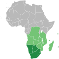
پرونده:Southern African Development Community.svg

حجم پیشنمایش PNG این SVG file:۶۰۰ × ۶۰۰ پیکسل کیفیتهای دیگر: ۲۴۰ × ۲۴۰ پیکسل | ۴۸۰ × ۴۸۰ پیکسل | ۷۶۸ × ۷۶۸ پیکسل | ۱٬۰۲۴ × ۱٬۰۲۴ پیکسل | ۲٬۰۴۸ × ۲٬۰۴۸ پیکسل | ۱٬۰۰۰ × ۱٬۰۰۰ پیکسل.
پروندهٔ اصلی (پروندهٔ اسویجی، با ابعاد ۱٬۰۰۰ × ۱٬۰۰۰ پیکسل، اندازهٔ پرونده: ۱۸۴ کیلوبایت)
تاریخچهٔ پرونده
روی تاریخ/زمانها کلیک کنید تا نسخهٔ مربوط به آن هنگام را ببینید.
| تاریخ/زمان | بندانگشتی | ابعاد | کاربر | توضیح | |
|---|---|---|---|---|---|
| کنونی | ۲۳ ژوئیهٔ ۲۰۱۸، ساعت ۱۰:۳۴ |  | ۱٬۰۰۰ در ۱٬۰۰۰ (۱۸۴ کیلوبایت) | Ydecreux | Added Comoros |
| ۲۱ نوامبر ۲۰۱۱، ساعت ۱۱:۵۹ |  | ۱٬۰۰۰ در ۱٬۰۰۰ (۱۸۴ کیلوبایت) | Htonl | color scheme | |
| ۲۰ نوامبر ۲۰۱۱، ساعت ۱۳:۲۰ |  | ۱٬۰۰۰ در ۱٬۰۰۰ (۱۸۴ کیلوبایت) | Htonl | == {{int:filedesc}} == {{Information |Description=Map of Africa showing the member nations of the w:Southern African Development Community (SADC). Nations that are members of SADC and the w:Southern African Customs Union (SACU) are coloured dark |
کاربرد پرونده
صفحهٔ زیر از این تصویر استفاده میکند:
کاربرد سراسری پرونده
ویکیهای دیگر زیر از این پرونده استفاده میکنند:
- کاربرد در af.wikipedia.org
- کاربرد در ar.wikipedia.org
- کاربرد در ast.wikipedia.org
- کاربرد در bg.wikipedia.org
- کاربرد در ca.wikipedia.org
- کاربرد در cs.wikipedia.org
- کاربرد در en.wikipedia.org
- کاربرد در es.wikipedia.org
- کاربرد در et.wikipedia.org
- کاربرد در eu.wikipedia.org
- کاربرد در fr.wikipedia.org
- کاربرد در hr.wikipedia.org
- کاربرد در id.wikipedia.org
- کاربرد در ko.wikipedia.org
- کاربرد در mg.wikipedia.org
- کاربرد در pl.wikipedia.org
- کاربرد در pnb.wikipedia.org
- کاربرد در pt.wikipedia.org
- کاربرد در ru.wikipedia.org
- کاربرد در sr.wikipedia.org
- کاربرد در sw.wikipedia.org
- کاربرد در tn.wikipedia.org
- کاربرد در vi.wikipedia.org
- کاربرد در www.wikidata.org
- کاربرد در zh.wikipedia.org
