
پرونده:Sir Bani Yas Island, United Arab Emirates.jpg

اندازهٔ این پیشنمایش: ۳۹۸ × ۵۹۹ پیکسل. کیفیتهای دیگر: ۱۵۹ × ۲۴۰ پیکسل | ۳۱۹ × ۴۸۰ پیکسل | ۵۱۰ × ۷۶۸ پیکسل | ۶۸۰ × ۱٬۰۲۴ پیکسل | ۱٬۳۶۰ × ۲٬۰۴۸ پیکسل | ۴٬۰۱۶ × ۶٬۰۴۸ پیکسل.
پروندهٔ اصلی (۴٬۰۱۶ × ۶٬۰۴۸ پیکسل، اندازهٔ پرونده: ۳٫۳۴ مگابایت، نوع MIME پرونده: image/jpeg)
این پرونده در ویکیانبار موجود است. محتویات صفحهٔ توصیف آن در زیر نمایش داده میشود. |
خلاصه
| توضیح |
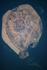
English: This astronaut photograph illustrates the varying character of surfaces on Sir Bani Yas. The central mountains of Jebel Wahid (image centre) mark the location of the Sir Bani Yas salt dome. The dome has breached the surface but exposed salt, primarily gypsum, is eroded, leaving a rugged, insoluble cap made of fragments of the overlaying sedimentary and volcanic rocks. Sand and silt derived from the Jebel Wahid and surrounding gravel-covered areas form beaches along the outer edge of the island. Tan graded areas along the western and north-eastern coast of the island (image bottom and image left) may be re-vegetated with additional plots or developed for other land uses. |
| تاریخ | |
| منبع | NASA Earth Observatory |
| پدیدآور | Image taken by the NASA Expedition 22 crew. |
Image provided by the ISS Crew Earth Observations experiment and Image Science & Analysis Laboratory, Johnson Space Center.
اجازهنامه
| این پرونده در مالکیت عمومی قرار دارد چرا که توسط ناسا ایجاد شده است. سیاست حق تکثیر ناسا بیان میکند که «مواد ناسا با حق تکثیر محافظت نمیشوند، مگراینکه ذکر شده باشد». (Template:PD-USGov، صفحهٔ سیاست حق تکثیر ناسا یا سیاست جیپیال استفاده از تصاویر را ببینید.) | ||
 |
هشدارها:
|
| برچسبها | این نگاره برچسپگذاری شدهاست: برچسپها را در ویکیانبار مشاهده کنید |
تاریخچهٔ پرونده
روی تاریخ/زمانها کلیک کنید تا نسخهٔ مربوط به آن هنگام را ببینید.
| تاریخ/زمان | بندانگشتی | ابعاد | کاربر | توضیح | |
|---|---|---|---|---|---|
| کنونی | ۲۹ مارس ۲۰۱۲، ساعت ۰۹:۱۶ | | ۴٬۰۱۶ در ۶٬۰۴۸ (۳٫۳۴ مگابایت) | Rotatebot | Bot: Image rotated by 90° |
| ۱۵ مارس ۲۰۱۰، ساعت ۱۱:۵۱ |  | ۶٬۰۴۸ در ۴٬۰۲۶ (۳٫۳۵ مگابایت) | Originalwana | {{Information |Description={{en|1=This astronaut photograph illustrates the varying character of surfaces on Sir Bani Yas. The central mountains of Jebel Wahid (image centre) mark the location of the Sir Bani Yas salt dome. The do |
کاربرد پرونده
صفحهٔ زیر از این تصویر استفاده میکند:
کاربرد سراسری پرونده
ویکیهای دیگر زیر از این پرونده استفاده میکنند:
- کاربرد در de.wikipedia.org
- کاربرد در en.wikipedia.org
- کاربرد در en.wikivoyage.org
- کاربرد در fi.wikipedia.org
- کاربرد در fr.wikipedia.org
- کاربرد در it.wikipedia.org
- کاربرد در ja.wikipedia.org
- کاربرد در pl.wikipedia.org
- کاربرد در tr.wikipedia.org
- کاربرد در www.wikidata.org