
پرونده:River Deltas, Lake Ayakum, Tibet.JPG

اندازهٔ این پیشنمایش: ۸۰۰ × ۵۳۲ پیکسل. کیفیتهای دیگر: ۳۲۰ × ۲۱۳ پیکسل | ۶۴۰ × ۴۲۵ پیکسل | ۱٬۰۲۴ × ۶۸۱ پیکسل | ۱٬۲۸۰ × ۸۵۱ پیکسل | ۲٬۵۶۰ × ۱٬۷۰۱ پیکسل | ۴٬۲۸۸ × ۲٬۸۵۰ پیکسل.
پروندهٔ اصلی (۴٬۲۸۸ × ۲٬۸۵۰ پیکسل، اندازهٔ پرونده: ۲٫۷۴ مگابایت، نوع MIME پرونده: image/jpeg)
این پرونده در ویکیانبار موجود است. محتویات صفحهٔ توصیف آن در زیر نمایش داده میشود. |
خلاصه
| توضیح |
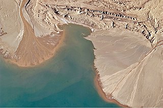
English: This astronaut photograph highlights two river deltas formed along Lake Ayakum's south-western shoreline. Gray to tan surfaces indicate prior positions of the river channels; the uniform coloration and smooth texture suggest that they are relatively old and now inactive. By contrast, the younger and currently active delta surfaces have reddish-brown sediment and visible river channels.
Lateral channel migration is particularly evident in the approximately 8-kilometer wide active delta at image upper left. The reddish color of the fresh sediment may indicate a change from the sources that formed the older parts of the deltas. It might indicate weathering and soil formation on the older deposits. It could even be a sign of episodic inputs of dust or other material to the river catchments. |
| تاریخ | |
| منبع | NASA Earth Observatory |
| پدیدآور | ISS Expedition 27 crew |
| مختصات دوربین | | محل قرارگیری این نگاره و سایر نگارهها در: نقشهٔ شهری باز |
|---|
این نگاره یا ویدیو توسط مرکز فضایی جانسون سازمان ملی هوانوردی و فضایی (NASA)ایالات متحدهٔ آمریکا تحت شناسهٔ عکس: ISS027-E-16922کاتالوگ شدهاست. این برچست وضعیت حق تکثیر اثر ضمیمه شده را مشخص نمیکند. یک برچسپ معمولی همچنان مورد نیاز است. Commons:Licensing را برای کسب اطلاعات مشاهده فرمایید. زبانهای دیگر:
|
Image acquired with a Nikon D2Xs digital camera using a 400 mm lens, and is provided by the ISS Crew Earth Observations experiment and Image Science & Analysis Laboratory, Johnson Space Center.
اجازهنامه
| این پرونده در مالکیت عمومی قرار دارد چرا که توسط ناسا ایجاد شده است. سیاست حق تکثیر ناسا بیان میکند که «مواد ناسا با حق تکثیر محافظت نمیشوند، مگراینکه ذکر شده باشد». (Template:PD-USGov، صفحهٔ سیاست حق تکثیر ناسا یا سیاست جیپیال استفاده از تصاویر را ببینید.) | ||
 |
هشدارها:
|
| برچسبها | این نگاره برچسپگذاری شدهاست: برچسپها را در ویکیانبار مشاهده کنید |
تاریخچهٔ پرونده
روی تاریخ/زمانها کلیک کنید تا نسخهٔ مربوط به آن هنگام را ببینید.
| تاریخ/زمان | بندانگشتی | ابعاد | کاربر | توضیح | |
|---|---|---|---|---|---|
| کنونی | ۱۲ مهٔ ۲۰۱۱، ساعت ۱۱:۵۰ | | ۴٬۲۸۸ در ۲٬۸۵۰ (۲٫۷۴ مگابایت) | Originalwana | {{Information |Description ={{en|1=This astronaut photograph highlights two river deltas formed along Lake Ayakum's south-western shoreline. Gray to tan surfaces indicate prior positions of the river channels; the uniform coloration and smooth |
کاربرد پرونده
صفحهٔ زیر از این تصویر استفاده میکند:
کاربرد سراسری پرونده
ویکیهای دیگر زیر از این پرونده استفاده میکنند:
- کاربرد در ceb.wikipedia.org
- کاربرد در en.wikipedia.org
- کاربرد در es.wikipedia.org
- کاربرد در it.wikipedia.org
- کاربرد در pa.wikipedia.org
- کاربرد در vi.wikipedia.org