
پرونده:Prunella laciniata range map.png
تفکیکپذیری بالاتری در دسترس نیست.
Prunella_laciniata_range_map.png (۶۵۰ × ۵۴۰ پیکسل، اندازهٔ پرونده: ۳۸ کیلوبایت، نوع MIME پرونده: image/png)
این پرونده در ویکیانبار موجود است. محتویات صفحهٔ توصیف آن در زیر نمایش داده میشود. |
خلاصه
| توضیح |
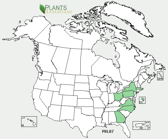
English: Prunella laciniata range map |
| منبع | http://plants.usda.gov/java/profile?symbol=PRLA7 |
| پدیدآور | USDA |
اجازهنامه
| This image is a work of the Natural Resources Conservation Service, part of the United States Department of Agriculture, taken or made as part of an employee's official duties. As a work of the U.S. federal government, the image is in the public domain in the United States. |
سیاهه بارگذاری اصلی
Transferred from en.wikipedia to Commons by Quadell using CommonsHelper.
صفحهٔ اصلی توضیحات اینجابود. همهٔ نامهای کاربر زیر به en.wikipedia اشاره دارند.
- 2009-12-15 19:50 Ecologygirl 650×540× (38519 bytes) {{Information |Description = Prunella laciniata range map |Source = http://plants.usda.gov/java/profile?symbol=PRLA7 |Date = ~~~~~ |Author = [[USDA]] |Permission = |other_versions = }} == Licensing == {{PD-USGov-U
تاریخچهٔ پرونده
روی تاریخ/زمانها کلیک کنید تا نسخهٔ مربوط به آن هنگام را ببینید.
| تاریخ/زمان | بندانگشتی | ابعاد | کاربر | توضیح | |
|---|---|---|---|---|---|
| کنونی | ۹ سپتامبر ۲۰۱۱، ساعت ۱۴:۱۴ | | ۶۵۰ در ۵۴۰ (۳۸ کیلوبایت) | File Upload Bot (Magnus Manske) | {{BotMoveToCommons|en.wikipedia|year={{subst:CURRENTYEAR}}|month={{subst:CURRENTMONTHNAME}}|day={{subst:CURRENTDAY}}}} {{Information |Description={{en|Prunella laciniata range map}} |Source=Transferred from [http://en.wikipedia.org en.wikipedia]; transfe |
کاربرد پرونده
صفحهٔ زیر از این تصویر استفاده میکند:
کاربرد سراسری پرونده
ویکیهای دیگر زیر از این پرونده استفاده میکنند:
- کاربرد در ceb.wikipedia.org
- کاربرد در cy.wikipedia.org
- کاربرد در en.wikipedia.org
- کاربرد در vi.wikipedia.org