
پرونده:Pinal County Arizona Incorporated and Unincorporated areas Superior highlighted.svg

حجم پیشنمایش PNG این SVG file:۸۰۰ × ۶۰۰ پیکسل کیفیتهای دیگر: ۳۲۰ × ۲۴۰ پیکسل | ۶۴۰ × ۴۸۰ پیکسل | ۱٬۰۲۴ × ۷۶۸ پیکسل | ۱٬۲۸۰ × ۹۶۰ پیکسل | ۲٬۵۶۰ × ۱٬۹۲۰ پیکسل.
پروندهٔ اصلی (پروندهٔ اسویجی، با ابعاد ۸۰۰ × ۶۰۰ پیکسل، اندازهٔ پرونده: ۱۵۲ کیلوبایت)
این پرونده در ویکیانبار موجود است. محتویات صفحهٔ توصیف آن در زیر نمایش داده میشود. |
خلاصه
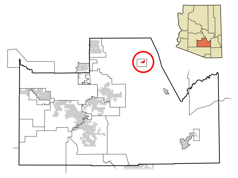
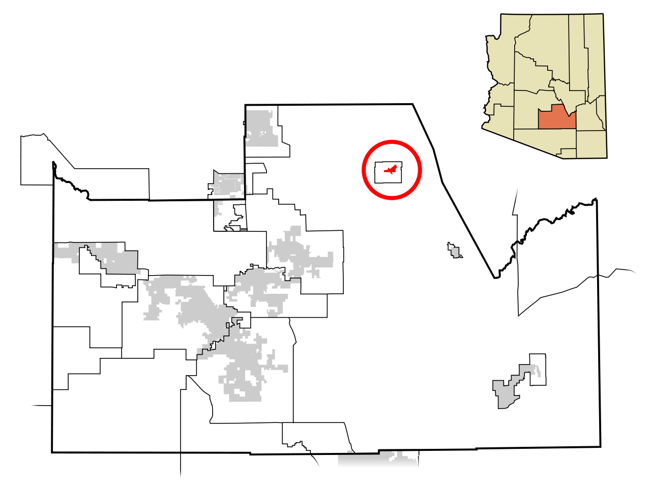
| توضیح | This map shows the incorporated areas and unincorporated areas in Pinal County, Arizona. Superior is highlighted in red. Other incorporated cities are shown in gray, planning area borders for these cities and Indian reservation borders are shown as solid black lines. Map data is based on the following files as noted, all of which are .pdf files: *Pinal County 2008 Comprehensive Plan Amendments (.pdf) - For determining incorporated and Indian reservation boundaries. *CAAG Pinal Planning Commissioners Presentation (.pdf) - For determining planning area boundaries in Pinal County. *CAAG Population Estimates for Pinal County Places (.pdf) - For determining boundaries of unincorporated areas in Pinal County. Additional data for cities shown are based on individual files from each city's Website. (Please view the category page for links to these files.) I created this map in Inkscape. Please Note: This file replaces Image:Pinal County Incorporated areas Superior highlighted.svg, which is now obsolete! |
| تاریخ | |
| منبع | My own work, based on public domain information |
| پدیدآور | Ixnayonthetimmay |
| اجازهنامه (استفادهٔ مجدد از این پرونده) |
Public Domain |
| دیگر نسخهها | See Category:Maps of Pinal County for other versions of this image. |
اجازهنامه
| من، دارنده حق تکثیر این اثر، این اثر را به مالکیت عمومی منتشر میکنم. این قابل اجرا در تمام نقاط جهان است. در برخی از کشورها ممکن است به صورت قانونی این امکانپذیر نباشد؛ اگر چنین است: من اجازهٔ استفاده از این اثر را برای هر مقصودی، بدون هیچگونه شرایطی میدهم، تا وقتی که این شرایط توسط قانون مستلزم نشده باشد. |
تاریخچهٔ پرونده
روی تاریخ/زمانها کلیک کنید تا نسخهٔ مربوط به آن هنگام را ببینید.
| تاریخ/زمان | بندانگشتی | ابعاد | کاربر | توضیح | |
|---|---|---|---|---|---|
| کنونی | ۸ ژوئیهٔ ۲۰۰۹، ساعت ۰۵:۴۴ | | ۸۰۰ در ۶۰۰ (۱۵۲ کیلوبایت) | Ixnayonthetimmay | == Summary == {{Information |Description=This map shows the incorporated areas and unincorporated areas in Pinal County, Arizona. [[:en:Gold Camp, Arizona|Gold |
| ۱۹ آوریل ۲۰۰۸، ساعت ۱۷:۵۶ |  | ۸۰۰ در ۶۰۰ (۱۵۶ کیلوبایت) | Ixnayonthetimmay | == Summary == {{Information |Description=This map shows the incorporated areas and unincorporated areas in Pinal County, Arizona. [[:en:Superior, Arizona|Superi |
کاربرد پرونده
صفحهٔ زیر از این تصویر استفاده میکند:
کاربرد سراسری پرونده
ویکیهای دیگر زیر از این پرونده استفاده میکنند:
- کاربرد در ar.wikipedia.org
- کاربرد در ca.wikipedia.org
- کاربرد در cy.wikipedia.org
- کاربرد در de.wikipedia.org
- کاربرد در eu.wikipedia.org
- کاربرد در fr.wikipedia.org
- کاربرد در ht.wikipedia.org
- کاربرد در it.wikipedia.org
- کاربرد در pt.wikipedia.org
- کاربرد در sr.wikipedia.org
- کاربرد در tt.wikipedia.org
- کاربرد در www.wikidata.org
- کاربرد در zh-min-nan.wikipedia.org