
پرونده:Panampangan Island.jpg

پروندهٔ اصلی (۳٬۹۷۳ × ۲٬۹۸۰ پیکسل، اندازهٔ پرونده: ۱٫۳۳ مگابایت، نوع MIME پرونده: image/jpeg)
این پرونده در ویکیانبار موجود است. محتویات صفحهٔ توصیف آن در زیر نمایش داده میشود. |
خلاصه
| توضیح |
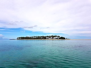
English: Panampangan island is located at the Basibuli Reef and possesses longest sandbar in the Philippines at the province of Tawi-Tawi. This was taken using the joint mapping, reconnaissance, and deployment mission of the Philippine Marine Corps and Schadow1 Expeditions |
||
| تاریخ | |||
| منبع | اثر شخصی | ||
| پدیدآور | Ervin Malicdem | ||
| اجازهنامه (استفادهٔ مجدد از این پرونده) |
این پرونده تحت پروانهٔ Creative Commons Attribution-Share Alike 4.0 International منتشر شده است.
|

| مختصات دوربین | | محل قرارگیری این نگاره و سایر نگارهها در: نقشهٔ شهری باز |
|---|
Initially published at Schadow1 Expeditions article available at http://www.s1expeditions.com/2017/06/217-panampangan-islandtawi-tawi.html
تاریخچهٔ پرونده
روی تاریخ/زمانها کلیک کنید تا نسخهٔ مربوط به آن هنگام را ببینید.
| تاریخ/زمان | بندانگشتی | ابعاد | کاربر | توضیح | |
|---|---|---|---|---|---|
| کنونی | ۱۵ سپتامبر ۲۰۱۷، ساعت ۰۷:۱۱ | | ۳٬۹۷۳ در ۲٬۹۸۰ (۱٫۳۳ مگابایت) | Schadow1 | User created page with UploadWizard |
کاربرد پرونده
صفحهٔ زیر از این تصویر استفاده میکند:
کاربرد سراسری پرونده
ویکیهای دیگر زیر از این پرونده استفاده میکنند:
- کاربرد در be.wikipedia.org
- کاربرد در bjn.wikipedia.org
- کاربرد در bn.wikipedia.org
- کاربرد در ceb.wikipedia.org
- کاربرد در en.wikipedia.org
- کاربرد در hr.wikipedia.org
- کاربرد در id.wikipedia.org
- کاربرد در ilo.wikipedia.org
- کاربرد در mk.wikipedia.org
- کاربرد در ms.wikipedia.org
- کاربرد در simple.wikipedia.org
- کاربرد در th.wikipedia.org
- کاربرد در tl.wikipedia.org
- کاربرد در vi.wikipedia.org
- کاربرد در www.wikidata.org
- کاربرد در zh.wikipedia.org