
پرونده:Overtoun Bridge - geograph.org.uk - 1024544.jpg
Overtoun_Bridge_-_geograph.org.uk_-_1024544.jpg (۶۴۰ × ۴۸۰ پیکسل، اندازهٔ پرونده: ۱۱۰ کیلوبایت، نوع MIME پرونده: image/jpeg)
این پرونده در ویکیانبار موجود است. محتویات صفحهٔ توصیف آن در زیر نمایش داده میشود. |
خلاصه
| توضیح |
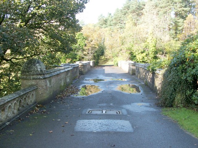
English: Overtoun Bridge. This thick-sided stone bridge, located next to 59380, has parapets on both sides; the river gorge that it crosses has sides that fall away steeply, and the river is therefore located a surprising distance below the bridge.
Overtoun House was built in 1859-63 for the Rutherglen chemical manufacturer James White (1735631), whose son became the first Lord Overtoun, but the bridge dates from 1895, and was built by H.E.Milner ["North Clyde Estuary - An Illustrated Architectural Guide", Frank Arneil Walker with Fiona Sinclair]. Although his son, John Campbell White (the aforementioned Lord Overtoun), was well known for his charitable works, he was famously lambasted in 1899 by Keir Hardie, who exposed the appalling working conditions faced by those employed in his chemical factory. [The location has featured in news reports more than once. In 1994, a mentally-disturbed man threw his two-week-old son to his death from the bridge. In October 2006, the fact that a surprising number of dogs have leapt to their death from the bridge was the subject of a television programme. This phenomenon has been reported under the sensational and misleading title of "dog suicides". Suggested explanations have ranged from the supernatural to peculiar sonic effects in the structure of the bridge; however, among the more plausible explanations is the idea that something (perhaps the scent of mink) is tempting dogs, from whose viewpoint the long drop is not apparent, to leap the bridge wall.] |
| تاریخ | |
| منبع | From geograph.org.uk |
| پدیدآور | Lairich Rig |
| انتساب (required by the license) | Lairich Rig / Overtoun Bridge / |
| مختصات دوربین | | محل قرارگیری این نگاره و سایر نگارهها در: نقشهٔ شهری باز |
|---|
_heading:292.00&language=fa)
| مختصات شیء | | محل قرارگیری این نگاره و سایر نگارهها در: نقشهٔ شهری باز |
|---|
_heading:292.00&language=fa)
اجازهنامه

|
این نگاره از مجموعهٔ پروژهٔ Geograph گرفته شدهاست. این صفحهٔ عکسها را در وبگاه Geograph برای جزئیات تماس با عکاس ببینید. حق تکثیر این تصویر به Lairich Rig تعلق دارد و برای استفادهٔ مجدد تحت Creative Commons Attribution-ShareAlike 2.0 مجوزدهی شدهاست.
|
- شما اجازه دارید:
- برای به اشتراک گذاشتن – برای کپی، توزیع و انتقال اثر
- تلفیق کردن – برای انطباق اثر
- تحت شرایط زیر:
- انتساب – شما باید اعتبار مربوطه را به دست آورید، پیوندی به مجوز ارائه دهید و نشان دهید که آیا تغییرات ایجاد شدهاند یا خیر. شما ممکن است این کار را به هر روش منطقی انجام دهید، اما نه به هر شیوهای که پیشنهاد میکند که مجوزدهنده از شما یا استفادهتان حمایت کند.
- انتشار مشابه – اگر این اثر را تلفیق یا تبدیل میکنید، یا بر پایه آن اثری دیگر خلق میکنید، میبایست مشارکتهای خود را تحت مجوز یکسان یا مشابه با ا اصل آن توزیع کنید.
تاریخچهٔ پرونده
روی تاریخ/زمانها کلیک کنید تا نسخهٔ مربوط به آن هنگام را ببینید.
| تاریخ/زمان | بندانگشتی | ابعاد | کاربر | توضیح | |
|---|---|---|---|---|---|
| کنونی | ۲۳ فوریهٔ ۲۰۱۱، ساعت ۱۴:۵۸ | | ۶۴۰ در ۴۸۰ (۱۱۰ کیلوبایت) | GeographBot | == {{int:filedesc}} == {{Information |description={{en|1=Overtoun Bridge This thick-sided stone bridge, located next to 59380, has parapets on both sides; the river gorge that it crosses has sides that fall away steeply, and the river is therefore loc |
کاربرد پرونده
صفحهٔ زیر از این تصویر استفاده میکند:
کاربرد سراسری پرونده
ویکیهای دیگر زیر از این پرونده استفاده میکنند:
- کاربرد در de.wikipedia.org
- کاربرد در fr.wikipedia.org
- کاربرد در hy.wikipedia.org
- کاربرد در it.wikipedia.org
- کاربرد در ru.wikipedia.org
- کاربرد در uk.wikipedia.org
- کاربرد در www.wikidata.org
- کاربرد در zh.wikipedia.org