
پرونده:OttomanEmpire1801.jpg
پروندهٔ اصلی (۱٬۶۳۸ × ۱٬۲۹۶ پیکسل، اندازهٔ پرونده: ۶۰۵ کیلوبایت، نوع MIME پرونده: image/jpeg)
این پرونده در ویکیانبار موجود است. محتویات صفحهٔ توصیف آن در زیر نمایش داده میشود. |

خلاصه
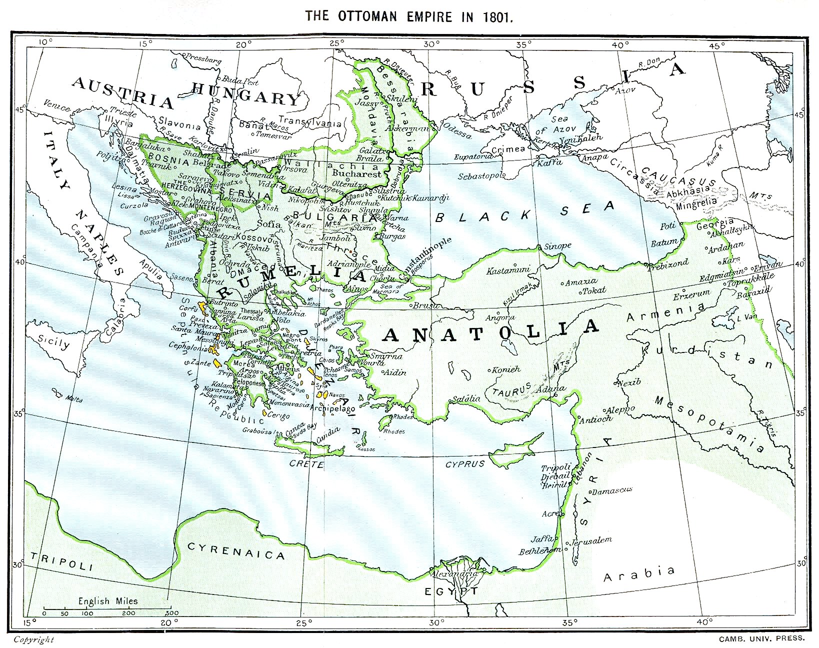
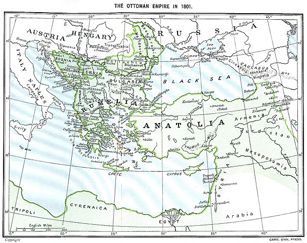
Ottoman Empire (green) and Septinsular Republic (yellow) in 1801.
اجازهنامه
|
این اثر در کشورهایی و مناطقی که مدت زمان حق تکثیر، عمر پدیدآورنده بعلاوهٔ ۷۰ سال یا کمتر بعد از مرگ او است، در مالکیت عمومی قرار دارد.
| |
| این پرونده تحت قانون حق تکثیر محدودیت آزاد منتشر شده که شامل تمامی حقوق مربوطه و حقوق نزدیک به آن میشود. | |
تاریخچهٔ پرونده
روی تاریخ/زمانها کلیک کنید تا نسخهٔ مربوط به آن هنگام را ببینید.
| تاریخ/زمان | بندانگشتی | ابعاد | کاربر | توضیح | |
|---|---|---|---|---|---|
| کنونی | ۱۱ ژانویهٔ ۲۰۲۳، ساعت ۱۶:۰۶ | | ۱٬۶۳۸ در ۱٬۲۹۶ (۶۰۵ کیلوبایت) | Enyavar | Reverted to version as of 08:56, 11 March 2006 (UTC) --> even if they are wrong, don't change historical maps! |
| ۳ فوریهٔ ۲۰۱۴، ساعت ۱۷:۴۸ |  | ۱٬۶۳۸ در ۱٬۲۹۶ (۵۱۸ کیلوبایت) | Spiridon Ion Cepleanu | Some little changes according with the 1801 situation : The Septinsular Rep. includes Ionian Is., not the Cyclades, Serbia became autonomous 1817... | |
| ۱۱ مارس ۲۰۰۶، ساعت ۰۸:۵۶ |  | ۱٬۶۳۸ در ۱٬۲۹۶ (۶۰۵ کیلوبایت) | Julo | Ottoman Empire (green) & Septinsular Republic (yellow) in 1801, on the 19th century map {{PD-old}} category:19th century mapsCategory:Historical maps of the Middle EastCategory:Historical maps of the Balkans[[Category:Historical maps of Africa |
کاربرد پرونده
این پرونده در هیچ صفحهای به کار نرفته است.
کاربرد سراسری پرونده
ویکیهای دیگر زیر از این پرونده استفاده میکنند:
- کاربرد در azb.wikipedia.org
- کاربرد در ba.wikipedia.org
- کاربرد در el.wikipedia.org
- کاربرد در en.wikipedia.org
- کاربرد در fr.wikipedia.org
- کاربرد در hy.wikipedia.org
- کاربرد در la.wikipedia.org
- کاربرد در pl.wikipedia.org
- کاربرد در sq.wikipedia.org
- کاربرد در sv.wikipedia.org
- کاربرد در uk.wikipedia.org