
پرونده:New sign marking the eastern boundary of Haigh - geograph.org.uk - 1045584.jpg
تفکیکپذیری بالاتری در دسترس نیست.
New_sign_marking_the_eastern_boundary_of_Haigh_-_geograph.org.uk_-_1045584.jpg (۶۴۰ × ۴۲۶ پیکسل، اندازهٔ پرونده: ۵۹ کیلوبایت، نوع MIME پرونده: image/jpeg)
این پرونده در ویکیانبار موجود است. محتویات صفحهٔ توصیف آن در زیر نمایش داده میشود. |
خلاصه
| توضیح |
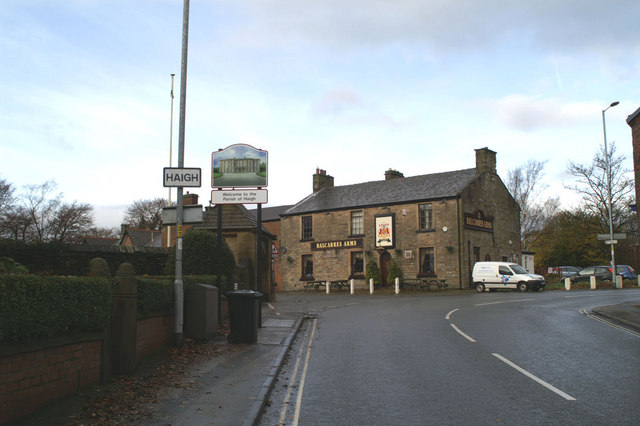
English: New sign marking the eastern boundary of Haigh This type of pictorial sign is being erected around Wigan Borough, largely at the request of local people, to mark the many separate communities, often old mining villages originally, which make up the modern Metropolitan Borough. The design is also often chosen after local consultation. Some show more imagination than others. Many share a common fault - the posts to which they are fixed straddle part of the pavement. They are too narrow to allow easy access between the posts, and yet are wide enough to leave inadequate space on the rest of the pavement for, say, a mother with a pram. Mothers bringing children to St David's School, to the left of the pub, may well have discovered this by now. |
| تاریخ | |
| منبع | From geograph.org.uk |
| پدیدآور | David Long |
| انتساب (required by the license) | David Long / New sign marking the eastern boundary of Haigh / |
| مختصات دوربین | | محل قرارگیری این نگاره و سایر نگارهها در: نقشهٔ شهری باز |
|---|
_heading:292.00&language=fa)
| مختصات شیء | | محل قرارگیری این نگاره و سایر نگارهها در: نقشهٔ شهری باز |
|---|
_heading:292.00&language=fa)
اجازهنامه

|
این نگاره از مجموعهٔ پروژهٔ Geograph گرفته شدهاست. این صفحهٔ عکسها را در وبگاه Geograph برای جزئیات تماس با عکاس ببینید. حق تکثیر این تصویر به David Long تعلق دارد و برای استفادهٔ مجدد تحت Creative Commons Attribution-ShareAlike 2.0 مجوزدهی شدهاست.
|
این پرونده با اجازهنامهٔ کریتیو کامانز Attribution-Share Alike 2.0 عمومی منتشر شده است.
انتساب: David Long
- شما اجازه دارید:
- برای به اشتراک گذاشتن – برای کپی، توزیع و انتقال اثر
- تلفیق کردن – برای انطباق اثر
- تحت شرایط زیر:
- انتساب – شما باید اعتبار مربوطه را به دست آورید، پیوندی به مجوز ارائه دهید و نشان دهید که آیا تغییرات ایجاد شدهاند یا خیر. شما ممکن است این کار را به هر روش منطقی انجام دهید، اما نه به هر شیوهای که پیشنهاد میکند که مجوزدهنده از شما یا استفادهتان حمایت کند.
- انتشار مشابه – اگر این اثر را تلفیق یا تبدیل میکنید، یا بر پایه آن اثری دیگر خلق میکنید، میبایست مشارکتهای خود را تحت مجوز یکسان یا مشابه با ا اصل آن توزیع کنید.
تاریخچهٔ پرونده
روی تاریخ/زمانها کلیک کنید تا نسخهٔ مربوط به آن هنگام را ببینید.
| تاریخ/زمان | بندانگشتی | ابعاد | کاربر | توضیح | |
|---|---|---|---|---|---|
| کنونی | ۲۳ فوریهٔ ۲۰۱۱، ساعت ۲۱:۵۵ | | ۶۴۰ در ۴۲۶ (۵۹ کیلوبایت) | GeographBot | == {{int:filedesc}} == {{Information |description={{en|1=New sign marking the eastern boundary of Haigh This type of pictorial sign is being erected around Wigan Borough, largely at the request of local people, to mark the many separate communities, often |
کاربرد پرونده
صفحهٔ زیر از این تصویر استفاده میکند:
کاربرد سراسری پرونده
ویکیهای دیگر زیر از این پرونده استفاده میکنند:
- کاربرد در ceb.wikipedia.org
- کاربرد در cy.wikipedia.org
- کاربرد در en.wikipedia.org
- کاربرد در lld.wikipedia.org
- کاربرد در www.wikidata.org