
پرونده:NGA-Pacific Loran.png

اندازهٔ این پیشنمایش: ۸۰۰ × ۵۸۹ پیکسل. کیفیتهای دیگر: ۳۲۰ × ۲۳۵ پیکسل | ۶۴۰ × ۴۷۱ پیکسل | ۱٬۰۲۴ × ۷۵۳ پیکسل | ۱٬۲۸۰ × ۹۴۲ پیکسل | ۲٬۰۴۴ × ۱٬۵۰۴ پیکسل.
پروندهٔ اصلی (۲٬۰۴۴ × ۱٬۵۰۴ پیکسل، اندازهٔ پرونده: ۳۳۳ کیلوبایت، نوع MIME پرونده: image/png)
این پرونده در ویکیانبار موجود است. محتویات صفحهٔ توصیف آن در زیر نمایش داده میشود. |
خلاصه
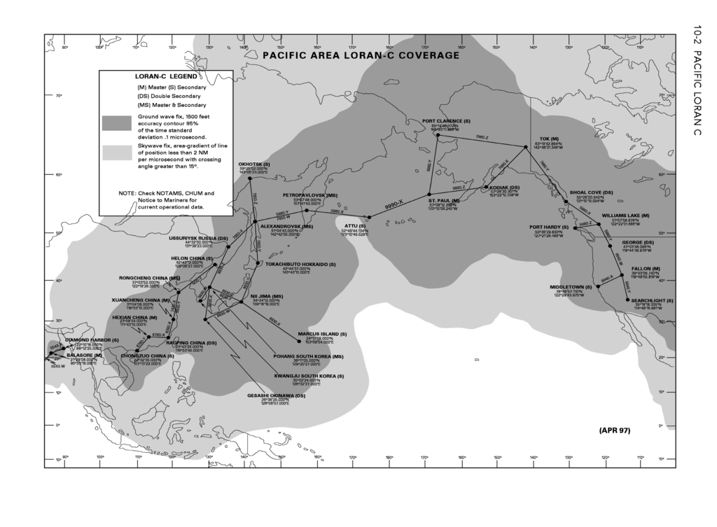
| توضیح |
English: Coverage of Pacific Ocean LORAN-C chains as in 2006. |
| تاریخ | (first publication of chart April 1997) |
| منبع | From DoD General Planning, 6 July 2006, NGA ref PLANXGP, page 10-2. |
| پدیدآور | unlisted - collective work |
| دیگر نسخهها |
This picture is part of a set: LORAN-C World coverage (2006)
|


اجازهنامه
This image is a work of the United States National Geospatial-Intelligence Agency or one of its predecessor agencies. As a work of the U.S. federal government, the image is in the public domain.
|
 |
This file was reviewed on 28 May 2009 by the administrator or trusted user Jappalang (talk), who confirmed the Public Domain status on that date.
See talk page for why this image's PD status was endorsed by PD reviewers. |
تاریخچهٔ پرونده
روی تاریخ/زمانها کلیک کنید تا نسخهٔ مربوط به آن هنگام را ببینید.
| تاریخ/زمان | بندانگشتی | ابعاد | کاربر | توضیح | |
|---|---|---|---|---|---|
| کنونی | ۴ مهٔ ۲۰۰۹، ساعت ۰۴:۵۱ | | ۲٬۰۴۴ در ۱٬۵۰۴ (۳۳۳ کیلوبایت) | Sv1xv | Landscape mode |
| ۴ مهٔ ۲۰۰۹، ساعت ۰۴:۴۹ |  | ۱٬۵۰۴ در ۲٬۰۴۴ (۴۱۵ کیلوبایت) | Sv1xv | Larger size. | |
| ۲۶ آوریل ۲۰۰۹، ساعت ۰۷:۰۲ |  | ۱٬۰۸۷ در ۷۹۹ (۲۴۱ کیلوبایت) | Sv1xv | {{Information |Description={{en|1=Coverage of Pacific Ocean LORAN-C chains as in 2006.}} |Source=From DoD ''General Planning, 6 July 2006'', NGA ref ''PLANXGP''. |Author=unlisted - collective work |Date=2006-07-06 |Permission= |other_versions= }} ==Licen |
کاربرد پرونده
صفحهٔ زیر از این تصویر استفاده میکند:
کاربرد سراسری پرونده
ویکیهای دیگر زیر از این پرونده استفاده میکنند: