
پرونده:Moss Landing California aerial view.jpg

اندازهٔ این پیشنمایش: ۸۰۰ × ۵۳۴ پیکسل. کیفیتهای دیگر: ۳۲۰ × ۲۱۴ پیکسل | ۶۴۰ × ۴۲۷ پیکسل | ۱٬۰۲۴ × ۶۸۳ پیکسل | ۱٬۵۰۰ × ۱٬۰۰۱ پیکسل.
پروندهٔ اصلی (۱٬۵۰۰ × ۱٬۰۰۱ پیکسل، اندازهٔ پرونده: ۶۴۴ کیلوبایت، نوع MIME پرونده: image/jpeg)
این پرونده در ویکیانبار موجود است. محتویات صفحهٔ توصیف آن در زیر نمایش داده میشود. |
| توضیح |
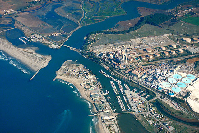
English: Aerial view of Moss Landing, Monterey County, California, USA. The Elkhorn slough runs the area and about 6 miles (8 km) inland. The huge Moss Landing Power Plant is visible at the center.
Coordinates: 36°48′21.95″N 121°46′57.55″W / 36.8060972°N 121.7826528°W |
|||
| مکان | Moss Landing, Monterey County, California, USA | |||
| تاریخ | not specified or unknown | |||
| منبع |
U.S. Army Corps of Engineers Digital Visual Library Image page Image description page Digital Visual Library home page |
|||
| پدیدآور | U.S. Army Corps of Engineers, photographer not specified or unknown | |||
| اجازهنامه (استفادهٔ مجدد از این پرونده) |
|
تاریخچهٔ پرونده
روی تاریخ/زمانها کلیک کنید تا نسخهٔ مربوط به آن هنگام را ببینید.
| تاریخ/زمان | بندانگشتی | ابعاد | کاربر | توضیح | |
|---|---|---|---|---|---|
| کنونی | ۴ مهٔ ۲۰۰۷، ساعت ۰۱:۳۵ | | ۱٬۵۰۰ در ۱٬۰۰۱ (۶۴۴ کیلوبایت) | DanMS | {{Information | Description = {{en|Aerial view of Moss Landing, Monterey County, California, USA. The Elkhorn slough runs the area and about 6 miles (8 km) inland. The huge Moss Landing Power Plant is visible at the center. }} Coordinates: {{Coor dms| |
کاربرد پرونده
صفحهٔ زیر از این تصویر استفاده میکند:
کاربرد سراسری پرونده
ویکیهای دیگر زیر از این پرونده استفاده میکنند:
- کاربرد در azb.wikipedia.org
- کاربرد در ceb.wikipedia.org
- کاربرد در de.wikipedia.org
- کاربرد در en.wikipedia.org
- کاربرد در es.wikipedia.org
- کاربرد در fr.wikipedia.org
- کاربرد در nl.wikipedia.org
- کاربرد در pt.wikipedia.org
- کاربرد در sr.wikipedia.org
- کاربرد در uk.wikipedia.org
- کاربرد در vi.wikipedia.org
- کاربرد در www.wikidata.org
- کاربرد در zh.wikipedia.org