
پرونده:Map to show the Limits of Kuwait and Adjacent Country (1913).jpg

اندازهٔ این پیشنمایش: ۶۱۴ × ۵۹۹ پیکسل. کیفیتهای دیگر: ۲۴۶ × ۲۴۰ پیکسل | ۴۹۲ × ۴۸۰ پیکسل | ۷۸۷ × ۷۶۸ پیکسل | ۱٬۰۵۰ × ۱٬۰۲۴ پیکسل | ۲٬۰۹۹ × ۲٬۰۴۸ پیکسل | ۳٬۴۵۷ × ۳٬۳۷۳ پیکسل.
پروندهٔ اصلی (۳٬۴۵۷ × ۳٬۳۷۳ پیکسل، اندازهٔ پرونده: ۱٫۱۳ مگابایت، نوع MIME پرونده: image/jpeg)
این پرونده در ویکیانبار موجود است. محتویات صفحهٔ توصیف آن در زیر نمایش داده میشود. |
.jpg?uselang=fa)
خلاصه
| توضیح |
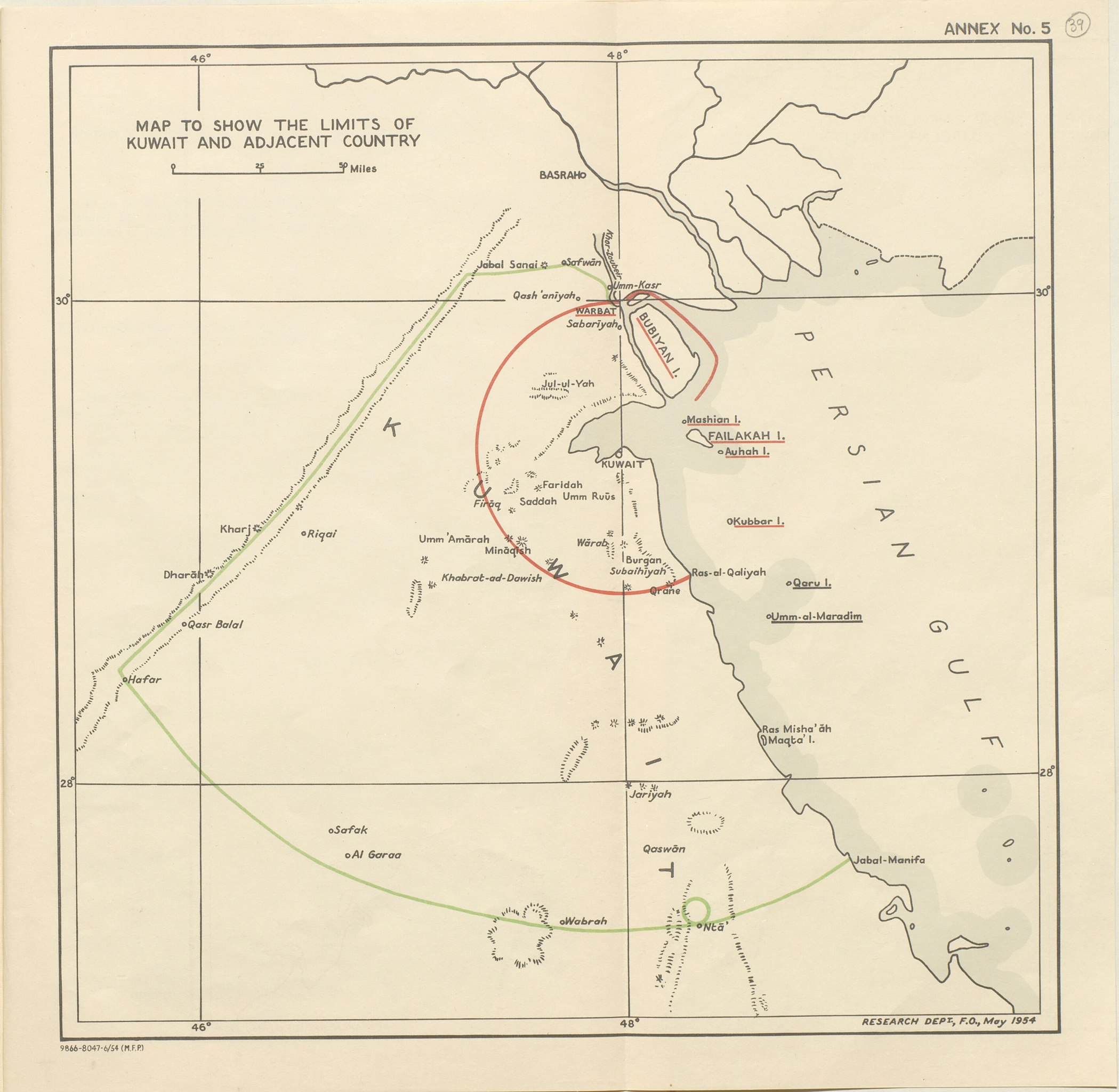
English: Map of the inner and outer zones of diminishing Kuwaiti Authority (Red Line and Green Line) defined by the 1913 Anglo-Ottoman Convention [1] |
| تاریخ | 1913? 1954? |
| منبع | https://www.qdl.qa/en/archive/81055/vdc_100023550810.0x000050 |
| پدیدآور | British Government |
اجازهنامه
This work created by the United Kingdom Government is in the public domain.
This is because it is one of the following:
HMSO has declared that the expiry of Crown Copyrights applies worldwide (ref: HMSO Email Reply)
|
 |
تاریخچهٔ پرونده
روی تاریخ/زمانها کلیک کنید تا نسخهٔ مربوط به آن هنگام را ببینید.
| تاریخ/زمان | بندانگشتی | ابعاد | کاربر | توضیح | |
|---|---|---|---|---|---|
| کنونی | ۲۶ ژوئیهٔ ۲۰۱۸، ساعت ۱۲:۳۷ | | ۳٬۴۵۷ در ۳٬۳۷۳ (۱٫۱۳ مگابایت) | Ratzer | Cropped 4 % horizontally, 6 % vertically using CropTool with precise mode. |
| ۲۶ ژوئیهٔ ۲۰۱۸، ساعت ۱۰:۰۲ |  | ۳٬۶۱۱ در ۳٬۶۰۰ (۱٫۳۱ مگابایت) | Ratzer | User created page with UploadWizard |
کاربرد پرونده
صفحهٔ زیر از این تصویر استفاده میکند:
کاربرد سراسری پرونده
ویکیهای دیگر زیر از این پرونده استفاده میکنند:
- کاربرد در ar.wikipedia.org
- کاربرد در bs.wikipedia.org
- کاربرد در en.wikipedia.org
- کاربرد در he.wikipedia.org
- کاربرد در hr.wikipedia.org
- کاربرد در id.wikipedia.org
- کاربرد در it.wikipedia.org
- کاربرد در ja.wikipedia.org
- کاربرد در mt.wikipedia.org
- کاربرد در nl.wikipedia.org
- کاربرد در ru.wikipedia.org
- کاربرد در uk.wikipedia.org
- کاربرد در www.wikidata.org
.jpg)