
پرونده:Map of south essex 1594 John Norden.jpg

اندازهٔ این پیشنمایش: ۸۰۰ × ۵۵۸ پیکسل. کیفیتهای دیگر: ۳۲۰ × ۲۲۳ پیکسل | ۶۴۰ × ۴۴۶ پیکسل | ۱٬۰۲۴ × ۷۱۴ پیکسل | ۱٬۲۹۳ × ۹۰۲ پیکسل.
پروندهٔ اصلی (۱٬۲۹۳ × ۹۰۲ پیکسل، اندازهٔ پرونده: ۸۹۹ کیلوبایت، نوع MIME پرونده: image/jpeg)
این پرونده در ویکیانبار موجود است. محتویات صفحهٔ توصیف آن در زیر نمایش داده میشود. |
خلاصه
| توضیح |
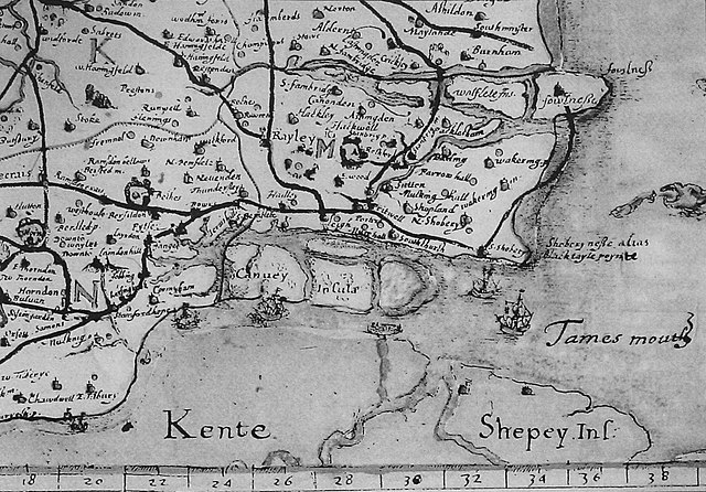
English: Image of John Norden's map of south east essex in 1594. The map shows the geographical status of the Canvey group of islands before the unifying reclamation project of 1622. |
| تاریخ | |
| منبع | John Norden. (1594). Speculi Brinanniæ Pars: an Historical and Chorographical Description of the County of Essex. First published in 1840 by the Camden Society, London. |
| پدیدآور | John Norden |
اجازهنامه
|
این اثر در کشورهایی و مناطقی که مدت زمان حق تکثیر، عمر پدیدآورنده بعلاوه 100 سال یا کمتر بعد از مرگ او است، در مالکیت عمومی قرار دارد. | |
| این پرونده تحت قانون حق تکثیر محدودیت آزاد منتشر شده که شامل تمامی حقوق مربوطه و حقوق نزدیک به آن میشود. | |
تاریخچهٔ پرونده
روی تاریخ/زمانها کلیک کنید تا نسخهٔ مربوط به آن هنگام را ببینید.
| تاریخ/زمان | بندانگشتی | ابعاد | کاربر | توضیح | |
|---|---|---|---|---|---|
| کنونی | ۳ ژوئن ۲۰۰۸، ساعت ۱۱:۲۹ | | ۱٬۲۹۳ در ۹۰۲ (۸۹۹ کیلوبایت) | Oneblackline | {{Information |Description={{en|1=Image of John Norden's map of south east essex in 1594. The map shows the geographical status of the Canvey group of islands before the unifying reclamation project of 1622.}} |Source=John Norden. (1594). Speculi Brinanni |
کاربرد پرونده
صفحهٔ زیر از این تصویر استفاده میکند:
کاربرد سراسری پرونده
ویکیهای دیگر زیر از این پرونده استفاده میکنند:
- کاربرد در ar.wikipedia.org
- کاربرد در azb.wikipedia.org
- کاربرد در en.wikipedia.org
- کاربرد در ru.wikipedia.org
- کاربرد در uk.wikipedia.org