
پرونده:Map of North America with the Western Interior Seaway during the Campanian (Upper Cretaceous).png

اندازهٔ این پیشنمایش: ۴۸۸ × ۶۰۰ پیکسل. کیفیتهای دیگر: ۱۹۵ × ۲۴۰ پیکسل | ۳۹۰ × ۴۸۰ پیکسل | ۶۲۵ × ۷۶۸ پیکسل | ۸۳۳ × ۱٬۰۲۴ پیکسل | ۱٬۹۴۵ × ۲٬۳۹۱ پیکسل.
پروندهٔ اصلی (۱٬۹۴۵ × ۲٬۳۹۱ پیکسل، اندازهٔ پرونده: ۳٫۹۵ مگابایت، نوع MIME پرونده: image/png)
این پرونده در ویکیانبار موجود است. محتویات صفحهٔ توصیف آن در زیر نمایش داده میشود. |
.png?uselang=fa)
خلاصه
| توضیح |
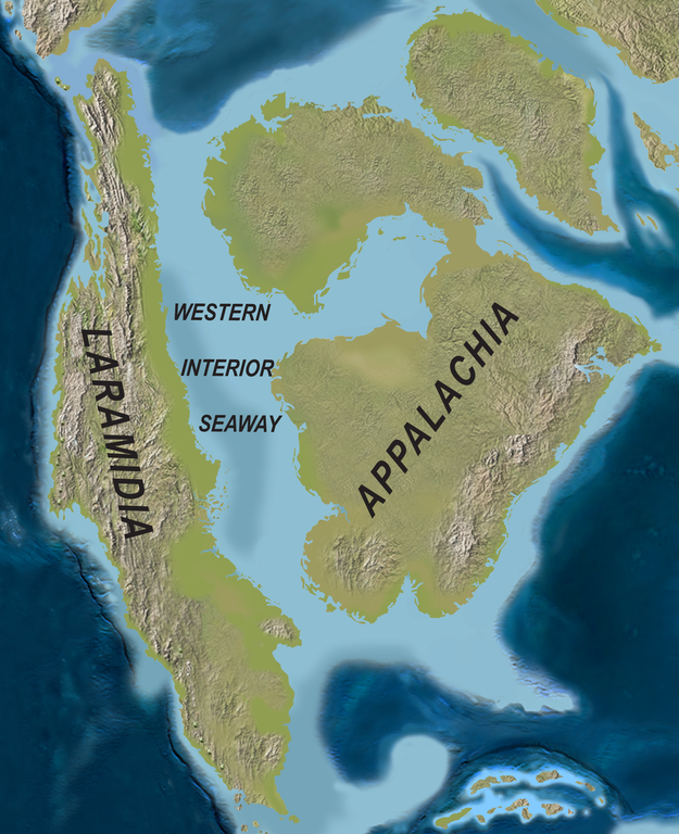
English: Map of North America with the Western Interior Seaway during the Campanian (Upper Cretaceous). Paleogeography of North America during the late Campanian Stage of the Late Cretaceous (∼75 Ma). Modified after Blakey.
Deutsch: Karte von Nordamerika mit dem Western Interior Seaway während des Campaniums (Obere Kreide) |
| تاریخ | |
| منبع | http://www.plosone.org/article/info%3Adoi%2F10.1371%2Fjournal.pone.0012292 |
| پدیدآور | Scott D. Sampson, Mark A. Loewen, Andrew A. Farke, Eric M. Roberts, Catherine A. Forster, Joshua A. Smith, Alan L. Titus |
| اجازهنامه (استفادهٔ مجدد از این پرونده) |
http://www.plosbiology.org/static/license.action |
اجازهنامه
این پوشه تحت مجوز Creative Commons Attribution 4.0 International مجوز داده شده است.
- شما اجازه دارید:
- برای به اشتراک گذاشتن – برای کپی، توزیع و انتقال اثر
- تلفیق کردن – برای انطباق اثر
- تحت شرایط زیر:
- انتساب – شما باید اعتبار مربوطه را به دست آورید، پیوندی به مجوز ارائه دهید و نشان دهید که آیا تغییرات ایجاد شدهاند یا خیر. شما ممکن است این کار را به هر روش منطقی انجام دهید، اما نه به هر شیوهای که پیشنهاد میکند که مجوزدهنده از شما یا استفادهتان حمایت کند.
تاریخچهٔ پرونده
روی تاریخ/زمانها کلیک کنید تا نسخهٔ مربوط به آن هنگام را ببینید.
| تاریخ/زمان | بندانگشتی | ابعاد | کاربر | توضیح | |
|---|---|---|---|---|---|
| کنونی | ۱ آوریل ۲۰۲۰، ساعت ۲۱:۰۸ | | ۱٬۹۴۵ در ۲٬۳۹۱ (۳٫۹۵ مگابایت) | FunkMonk | {{Information |Description = {{en|1=Map of North America with the Western Interior Seaway during the Campanian (Upper Cretaceous). Paleogeography of North America during the late Campanian Stage of the Late Cretaceous (∼75 Ma). Modified after Blakey.}} {{de|1=Karte von Nordamerika mit dem Western Interior Seaway während des Campaniums (Obere Kreide)}} |Source =http://www.plosone.org/article/info%3Adoi%2F10.1371%2Fjournal.pone.0012292 |Author =Scott D. Sampson, Mark A. Loewe... |
کاربرد پرونده
صفحهٔ زیر از این تصویر استفاده میکند:
کاربرد سراسری پرونده
ویکیهای دیگر زیر از این پرونده استفاده میکنند:
- کاربرد در de.wiktionary.org
- کاربرد در en.wikipedia.org
- کاربرد در fr.wikipedia.org
- کاربرد در id.wikipedia.org
- کاربرد در it.wikipedia.org
- کاربرد در ne.wikipedia.org
- کاربرد در nl.wikipedia.org
- کاربرد در pl.wikipedia.org
- کاربرد در pl.wiktionary.org
- کاربرد در pt.wikipedia.org
- کاربرد در ru.wikipedia.org
- کاربرد در tr.wikipedia.org
- کاربرد در uk.wikipedia.org
- کاربرد در zh.wikipedia.org
.png)