
پرونده:Map of Iraq, 1976.jpg

اندازهٔ این پیشنمایش: ۶۲۱ × ۵۹۹ پیکسل. کیفیتهای دیگر: ۲۴۹ × ۲۴۰ پیکسل | ۴۹۷ × ۴۸۰ پیکسل | ۷۹۶ × ۷۶۸ پیکسل | ۱٬۰۶۴ × ۱٬۰۲۷ پیکسل.
پروندهٔ اصلی (۱٬۰۶۴ × ۱٬۰۲۷ پیکسل، اندازهٔ پرونده: ۳۹۵ کیلوبایت، نوع MIME پرونده: image/jpeg)
این پرونده در ویکیانبار موجود است. محتویات صفحهٔ توصیف آن در زیر نمایش داده میشود. |
| توضیح |
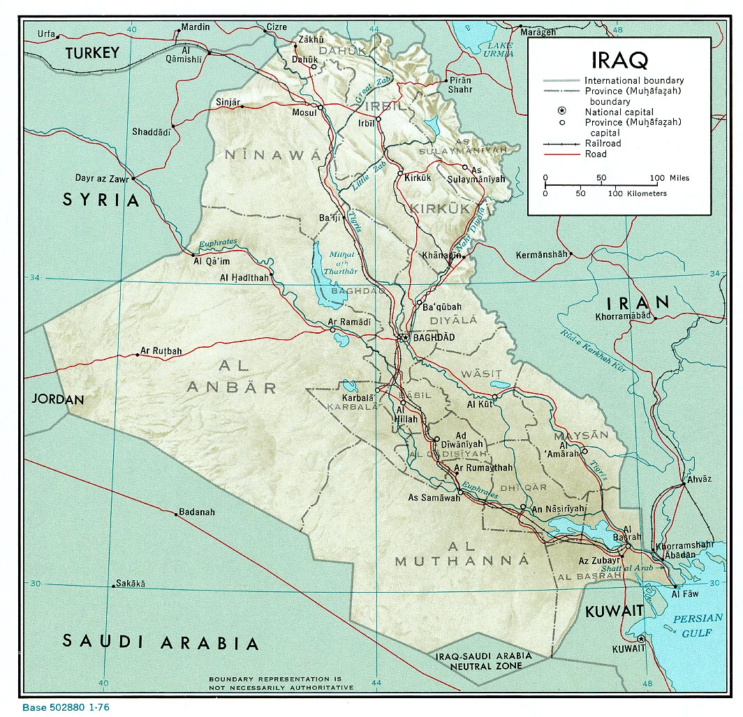
English: A map of Iraq, drawn in 1976. It shows the old province boundaries and other topographical detail. It is referred to here as a work of the CIA. |
|||
| تاریخ | ||||
| منبع | http://www.lib.utexas.edu/maps/middle_east_and_asia/iraq_rel_1976.jpg | |||
| پدیدآور | Employee(s) of the Central Intelligence Agency | |||
| اجازهنامه (استفادهٔ مجدد از این پرونده) |
|
|||
| دیگر نسخهها |
File:Neutralzone.jpg, cropped section of Neutral Zone. File:Map of Iraq, 1976-ar.jpg, in Arabic |

تاریخچهٔ پرونده
روی تاریخ/زمانها کلیک کنید تا نسخهٔ مربوط به آن هنگام را ببینید.
| تاریخ/زمان | بندانگشتی | ابعاد | کاربر | توضیح | |
|---|---|---|---|---|---|
| کنونی | ۱۱ ژوئن ۲۰۱۰، ساعت ۱۳:۰۳ | | ۱٬۰۶۴ در ۱٬۰۲۷ (۳۹۵ کیلوبایت) | Jarry1250 | {{Information |Description={{en|1=A map of Iraq, drawn in 1976. It shows the old province boundaries and other topographical detail. It is referred to [http://www.lib.utexas.edu/maps/iraq.html here] as a work of the CIA.}} |Source=http://www.lib.utexas. |
کاربرد پرونده
صفحهٔ زیر از این تصویر استفاده میکند:
کاربرد سراسری پرونده
ویکیهای دیگر زیر از این پرونده استفاده میکنند:
- کاربرد در ar.wikipedia.org
- کاربرد در en.wikipedia.org
- کاربرد در es.wikipedia.org
- کاربرد در zh.wikipedia.org