
پرونده:Map of Central Asia with trade routes and movements, von Richthofen.png
اندازهٔ این پیشنمایش: ۸۰۰ × ۴۸۳ پیکسل. کیفیتهای دیگر: ۳۲۰ × ۱۹۳ پیکسل | ۶۴۰ × ۳۸۶ پیکسل | ۱٬۰۲۴ × ۶۱۸ پیکسل | ۱٬۲۸۰ × ۷۷۲ پیکسل | ۲٬۰۳۴ × ۱٬۲۲۷ پیکسل.
پروندهٔ اصلی (۲٬۰۳۴ × ۱٬۲۲۷ پیکسل، اندازهٔ پرونده: ۴٫۸ مگابایت، نوع MIME پرونده: image/png)
این پرونده در ویکیانبار موجود است. محتویات صفحهٔ توصیف آن در زیر نمایش داده میشود. |
خلاصه
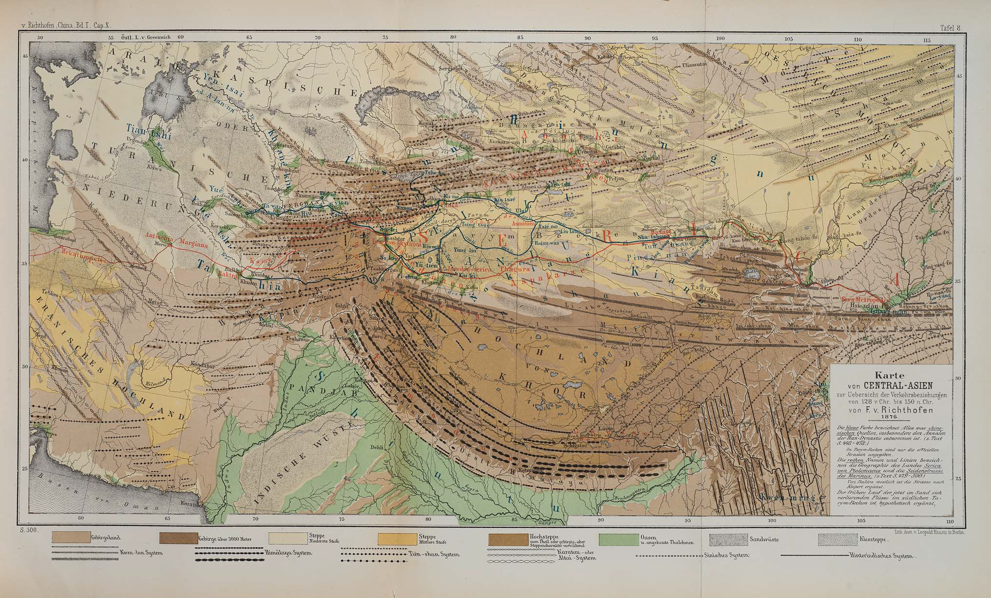
| توضیح | Map of Central Asia for overview of trade routes and movements from 128 BC to 150 AD |
| تاریخ |
Dated 1876 Published 1877 |
| منبع |
F. von Richthofen (1877). China: Ergebnisse eigener Reisen und darauf gegründeter Studien. Band 1, Einleitender Theil [China: Expedition results and studies based thereupon. Volume 1, Introductory Part]. Berlin: Verlag von Dietrich Reimer. As reproduced in James D. Sidaway & Chih Yuan Woon (2017). Chinese Narratives on “One Belt, One Road” (一带一路) in Geopolitical and Imperial Contexts. The Professional Geographer 69(4), 591-603. doi: 10.1080/00330124.2017.1288576 |
| پدیدآور | F. von Richthofen (1833–1905) |
| دیگر نسخهها |
.png)
اجازهنامه
|
این اثر در کشورهایی و مناطقی که مدت زمان حق تکثیر، عمر پدیدآورنده بعلاوه 100 سال یا کمتر بعد از مرگ او است، در مالکیت عمومی قرار دارد. | |
| این پرونده تحت قانون حق تکثیر محدودیت آزاد منتشر شده که شامل تمامی حقوق مربوطه و حقوق نزدیک به آن میشود. | |
| برچسبها | این نگاره برچسپگذاری شدهاست: برچسپها را در ویکیانبار مشاهده کنید |
تاریخچهٔ پرونده
روی تاریخ/زمانها کلیک کنید تا نسخهٔ مربوط به آن هنگام را ببینید.
| تاریخ/زمان | بندانگشتی | ابعاد | کاربر | توضیح | |
|---|---|---|---|---|---|
| کنونی | ۲۴ نوامبر ۲۰۱۸، ساعت ۰۸:۱۴ | | ۲٬۰۳۴ در ۱٬۲۲۷ (۴٫۸ مگابایت) | Cold Season | {{Information |Description= Map of Central Asia for overview of trade routes and movements. |Source= Von Richthofen, F. (1877). ''China: Ergebnisse eigener Reisen und darauf gegründeter Studien''. Band 1, Einleitender Theil [China: Expedition results and studies based thereupon. Volume 1, Introductory Part]. Berlin: Verlag von Dietrich Reimer. As reproduced in James D. Sidaway & Chih Yuan Woon (2017) Chinese Narratives on “One Belt, One Road” (一带一路) in Geopolitical and Imperial Contexts, ''T... |
کاربرد پرونده
صفحهٔ زیر از این تصویر استفاده میکند:
کاربرد سراسری پرونده
ویکیهای دیگر زیر از این پرونده استفاده میکنند:
- کاربرد در en.wikipedia.org
- کاربرد در et.wikipedia.org
- کاربرد در he.wikipedia.org
- کاربرد در ko.wikipedia.org
- کاربرد در pt.wikipedia.org
- کاربرد در sl.wikipedia.org
- کاربرد در th.wikipedia.org