
پرونده:Location of municipalities within the Dodecanese Islands.png
اندازهٔ این پیشنمایش: ۷۸۷ × ۶۰۰ پیکسل. کیفیتهای دیگر: ۳۱۵ × ۲۴۰ پیکسل | ۶۳۰ × ۴۸۰ پیکسل | ۱٬۰۰۰ × ۷۶۲ پیکسل.
پروندهٔ اصلی (۱٬۰۰۰ × ۷۶۲ پیکسل، اندازهٔ پرونده: ۸۵ کیلوبایت، نوع MIME پرونده: image/png)
این پرونده در ویکیانبار موجود است. محتویات صفحهٔ توصیف آن در زیر نمایش داده میشود. |
خلاصه
| توضیح |
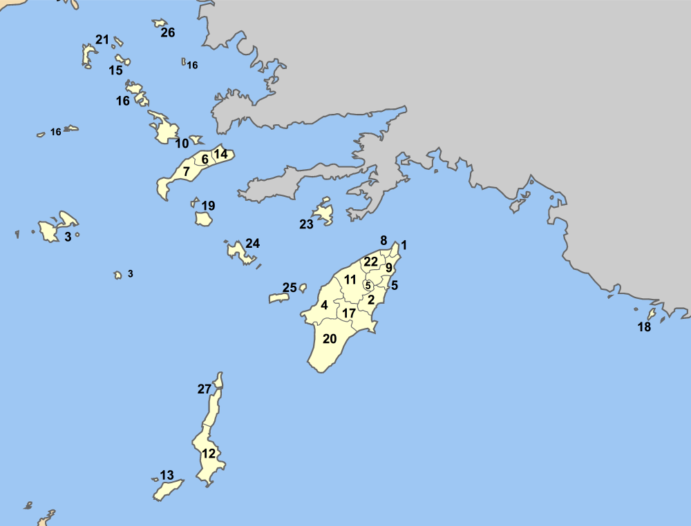
Map of Dodecanese prefecture (Greece) with administrative divisions (municipalities and communities) numbered in alphabetical order (in greek). Legend:
|
| تاریخ | |
| منبع | اثر شخصی |
| پدیدآور | Pitichinaccio |
اجازهنامه
| من، دارنده حق تکثیر این اثر، این اثر را به مالکیت عمومی منتشر میکنم. این قابل اجرا در تمام نقاط جهان است. در برخی از کشورها ممکن است به صورت قانونی این امکانپذیر نباشد؛ اگر چنین است: من اجازهٔ استفاده از این اثر را برای هر مقصودی، بدون هیچگونه شرایطی میدهم، تا وقتی که این شرایط توسط قانون مستلزم نشده باشد. |
تاریخچهٔ پرونده
روی تاریخ/زمانها کلیک کنید تا نسخهٔ مربوط به آن هنگام را ببینید.
| تاریخ/زمان | بندانگشتی | ابعاد | کاربر | توضیح | |
|---|---|---|---|---|---|
| کنونی | ۲۹ اوت ۲۰۰۷، ساعت ۰۸:۱۱ | | ۱٬۰۰۰ در ۷۶۲ (۸۵ کیلوبایت) | Pitichinaccio | {{Information |Description=Map of Dodecanese prefecture (Greece) with administrative divisions (municipalities and communities) numbered in alphabetical order (in greek). Legend: * 1 Δήμος Ρόδου - Rhodos * 2 Δήμος Αρχαγγέλου - Ar |
کاربرد پرونده
صفحهٔ زیر از این تصویر استفاده میکند:
کاربرد سراسری پرونده
ویکیهای دیگر زیر از این پرونده استفاده میکنند:
- کاربرد در de.wikipedia.org
- کاربرد در el.wikipedia.org
- کاربرد در en.wikipedia.org
- کاربرد در eo.wikipedia.org
- کاربرد در fi.wikipedia.org
- کاربرد در fr.wikipedia.org
- کاربرد در gl.wikipedia.org
- کاربرد در hr.wikipedia.org
- کاربرد در it.wikipedia.org
- کاربرد در ja.wikipedia.org
- کاربرد در ko.wikipedia.org
- کاربرد در la.wikipedia.org
- کاربرد در mk.wikipedia.org
- کاربرد در ru.wikipedia.org
- کاربرد در tr.wikipedia.org