
پرونده:Lawrence of Arabia's map, presented to the Eastern Committee of the War Cabinet in November 1918.jpg
پروندهٔ اصلی (۲٬۰۴۸ × ۱٬۹۲۳ پیکسل، اندازهٔ پرونده: ۱٫۰۱ مگابایت، نوع MIME پرونده: image/jpeg)
این پرونده در ویکیانبار موجود است. محتویات صفحهٔ توصیف آن در زیر نمایش داده میشود. |
خلاصه
| توضیح |
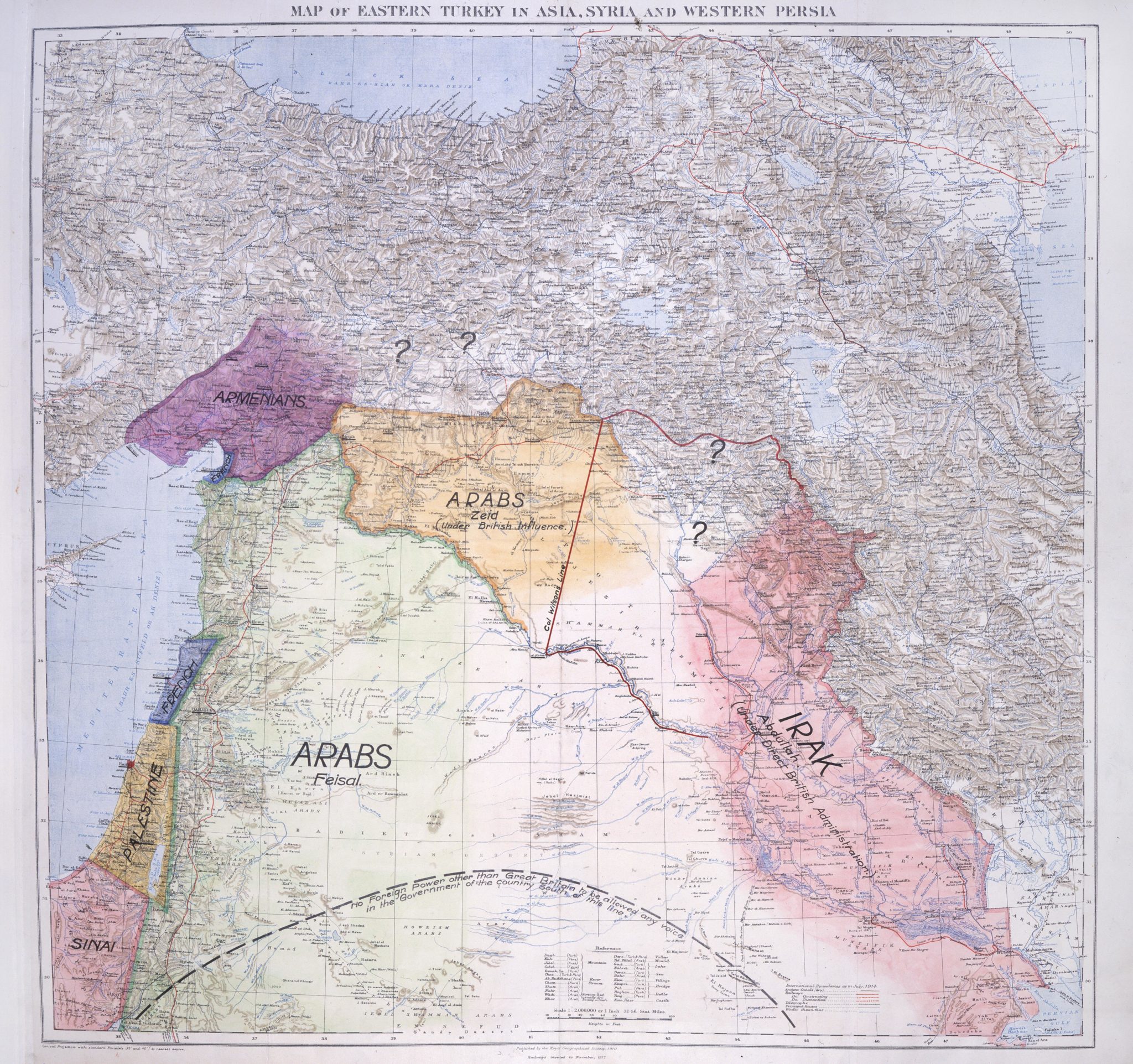
English: Lawrence of Arabia's map, presented to the Eastern Committee of the War Cabinet in November 1918. From the British National Archives
العربية: خريطة لورنس العرب ، عُرضت على اللجنة الشرقية لمجلس وزراء الحرب في نوفمبر ١٩١٨. من الأرشيف الوطني البريطاني |
| تاریخ | |
| منبع |
British National Archives |
| پدیدآور | T. E. Lawrence |
| دیگر نسخهها | File:Lawrence of Arabia Middle East proposal.svg |
اجازهنامه
این پروندهٔ رسانهای در ایالات متحده در مالکیت عمومی قرار دارد. این دربارهٔ آثار ایالات متحده که حقتکثیرشان باطل شده است صدق میکند؛ اغلب به این دلیل که اولین انتشارشان قبل از ۱ ژانویهٔ ۱۹۲۹ روی داده است. برای توضیحات بیشتر این صفحه را ببینید.
|
 | |
 |
ممکن است این نگاره در خارج از ایالات متحده در مالکیت عمومی نباشد؛ این مسئله بهخصوص دربارهٔ کشورها و مناطقی که قانون مدت کوتاهتر را برای آثار ایالات متحدهٔ آمریکا اعمال نمیکنند، همچون کانادا، چین (به جز هنگکنگ و ماکائو)، آلمان، مکیزیک، و سوئیس صدق میکند. آفریننده و سال انتشار اطلاعات ضروری هستند و باید ارائه شوند. برای جزئیات بیشتر، ویکیپدیا:مالکیت عمومی و ویکیپدیا:حق تکثیر را ببینید.
|
This work created by the United Kingdom Government is in the public domain.
This is because it is one of the following:
HMSO has declared that the expiry of Crown Copyrights applies worldwide (ref: HMSO Email Reply)
|
 |
|
این اثر در کشورهایی و مناطقی که مدت زمان حق تکثیر، عمر پدیدآورنده بعلاوه 70 سال یا کمتر بعد از مرگ او است، در مالکیت عمومی قرار دارد.
| |
| این پرونده تحت قانون حق تکثیر محدودیت آزاد منتشر شده که شامل تمامی حقوق مربوطه و حقوق نزدیک به آن میشود. | |
تاریخچهٔ پرونده
روی تاریخ/زمانها کلیک کنید تا نسخهٔ مربوط به آن هنگام را ببینید.
| تاریخ/زمان | بندانگشتی | ابعاد | کاربر | توضیح | |
|---|---|---|---|---|---|
| کنونی | ۱۳ اکتبر ۲۰۲۰، ساعت ۱۲:۴۵ | | ۲٬۰۴۸ در ۱٬۹۲۳ (۱٫۰۱ مگابایت) | MordredDerby | Higher resolution |
| ۲۱ آوریل ۲۰۱۳، ساعت ۱۷:۵۳ |  | ۸۰۰ در ۷۶۹ (۱۵۲ کیلوبایت) | Onceinawhile | User created page with UploadWizard |
کاربرد پرونده
صفحهٔ زیر از این تصویر استفاده میکند:
کاربرد سراسری پرونده
ویکیهای دیگر زیر از این پرونده استفاده میکنند:
- کاربرد در ar.wikipedia.org
- کاربرد در arz.wikipedia.org
- کاربرد در bn.wikipedia.org
- کاربرد در ckb.wikipedia.org
- کاربرد در de.wikipedia.org
- کاربرد در en.wikipedia.org
- کاربرد در es.wikipedia.org
- کاربرد در fi.wikipedia.org
- کاربرد در fr.wikipedia.org
- کاربرد در id.wikipedia.org
- کاربرد در it.wikipedia.org
- کاربرد در ko.wikipedia.org
- کاربرد در ml.wikipedia.org
- کاربرد در ru.wikipedia.org
- کاربرد در sr.wikipedia.org
- کاربرد در tr.wikipedia.org