
پرونده:Lameroo Catholic Church in the Murray Mallee South Australia. (7524841078).jpg

پروندهٔ اصلی (۳٬۶۴۸ × ۲٬۷۳۶ پیکسل، اندازهٔ پرونده: ۳٫۵۵ مگابایت، نوع MIME پرونده: image/jpeg)
این پرونده در ویکیانبار موجود است. محتویات صفحهٔ توصیف آن در زیر نمایش داده میشود. |
.jpg?uselang=fa)
خلاصه
| توضیح |
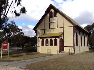
Lameroo Catholic Church. Much of the land around present day Lameroo was taken up as pastoral leases in 1859 for Horatio Williams and John Bagot as part of Garra station. Gradually all the leases of Garra and other runs were taken over by Mrs. Isabella Baker, wife of the late John Baker of Tungkillo and Narrung. She owned Garra by 1875 and passed the leases on to her son Alan Baker. The plains of Wow Wow were quite successful for raising sheep unlike the country to the east near Pinnaroo. When the leases of Garra expired in 1891 the government did not renew them. It was considering opening the country up for farming. All leases in the area had expired by 1893 when Goyder, and later a group of parliamentarians rode their horses out to examine the district with a view to new farming settlement. The Tailem Bend to Pinnaroo Railway Act was then passed in 1893 although it was 1906 before the railway and a few settlers arrived at Lameroo. Thomas Leckie was the first to take up farming land in the Hundred of Bews where Lameroo stands. He arrived here in 1897, followed by James Byrne in 1898 and William Harvey in 1901. Most settlers arrived after the railway reached Lameroo in September 1906. Farmers flocked to the district; Mallee was felled, burnt and cleared; stump jump ploughs purchased; and the first season provided a bumper crop of wheat. Within a few years Lameroo was a growing settlement with women and children in town, a school, a hotel, store and provisions for church services in people’s houses. It was the late 1920s before a series of lower than average rainfalls were recorded in Lameroo to dampen this growth. The town of Lameroo was surveyed in two parts one in 1904 and the other in 1907 by the government surveyor Mr Poyntz- hence Poyntz Street in Lameroo today. The focus of the town centre was the railway station and yard. This was the lifeblood of the settlement. The school reserve was sited to the east of the Bews Terrace where it still stands. The Settlers Hotel began in 1905; the first Methodist Church was started in 1906 and used as the first school room; Eudunda Farmers took a lease out on a building for their town general store in 1907. All of these early buildings were timber and iron as there was no suitable building stone in the region. Lameroo looked like an impermanent settlement because of these tin structures but despite the hot summers, timber and iron buildings were quick, easy and cheap to erect. The large O’Connor General Store opened in 1907 on the site it still occupies. It also served as the first unofficial Post Office. The Lameroo Institute Hall opened in 1909 thus allowing dances in Lameroo. Prior to this the Methodist Hall was used for social functions but dances were not allowed! A butcher’s shop, a resident doctor, a carpenter and wheelwright all opened up premises in Lameroo by 1909. A town had been born and was screaming with business by 1909, following just over two years of activity since most town blocks had only been sold in early 1907. Eudunda Farmers need special mention. It not only purchased Mallee roots or logs from farmers but it sold them superphosphate and other farm supplies. Its general store in town sold groceries but it also had a bakery by 1911, and a dressmaker from 1909 for the town ladies. These services operated in the former O’Connor Store which Eudunda Farmers had purchased in 1909. They operated from here until their new building was completed in the Main Street in 1937. Some significant historic structures in Lameroo today are: •St. John’s Lutheran Church 1966. The original Lutheran Church of 1908 was on this site. •the original Lameroo hospital was a tin house opened in 1912 as the Pinnaroo District Hospital. A new wing was opened in 1966 followed by another wing in 1978.It has had additions since then. •Millers’ General stores (was O’Connor’s in 1907). •the old Police Station and first Court House constructed in stone in 1909; a new police station was built elsewhere in 1981. •the Eudunda Farmers store manager’s residence (one of the few stone structures)at 26 Railway Tce. •the distinctive pressed tin houses in Vardon Terrace and the first doctor’s residence on the corner of Poyntz St. and Vardon Tce. The second Lutheran church( demolished) of Lameroo had their church in Vardon Tce. •the IGA Supermarket 1937 ( is Eudunda Farmers Store number seven in 1907), still. •the first Official Post Office opened in 1911, corner of North Avenue and Railway Terrace. Now demolished. •The original Settlers Hotel was demolished and in 1925 as the Commercial Hotel erected. In 1949 the hotel became a community owned hotel. Third hotel erected again in 1975 demolishing all of the 1925 buildings. •the old school opened in 1910. It was extended in 1915; and offered high school subjects as a Higher Primary School from 1921. It became an area school in 1945; and the only high school in the region in 1990. A new school structure was opened in 1974. •the Catholic Church – opened in 1911- strong Germanic influence and unusual construction. Timber frame; stucco wall panels; steeply pitched roof; overhanging eaves. Originally it had a fine bell tower on the roof now removed. •St. John the Baptist Anglican Church first opened in 1910 as a Mission Hall. It was dedicated as a church in 1928 or 1930. It was an all tin construction with gothic style windows. In 1962 a new stone Anglican Church was opened. •the Methodist, now Uniting Church- 1956. The first church was behind the current church but is now demolished. •the Lameroo Institute Hall opened in 1909 as a large tin room. A new Institute was erected in front of it in 1926. The present concrete hall which necessitated the demolition of the first two halls was completed in 1961. |
| تاریخ | |
| منبع | Lameroo Catholic Church in the Murray Mallee South Australia. |
| پدیدآور | denisbin from Adelaide, Australia |
| مختصات دوربین | | محل قرارگیری این نگاره و سایر نگارهها در: نقشهٔ شهری باز |
|---|
.jpg¶ms=-35.330295_N_0140.520318_E_globe:Earth_type:camera_source:Flickr_&language=fa)
اجازهنامه
- شما اجازه دارید:
- برای به اشتراک گذاشتن – برای کپی، توزیع و انتقال اثر
- تلفیق کردن – برای انطباق اثر
- تحت شرایط زیر:
- انتساب – شما باید اعتبار مربوطه را به دست آورید، پیوندی به مجوز ارائه دهید و نشان دهید که آیا تغییرات ایجاد شدهاند یا خیر. شما ممکن است این کار را به هر روش منطقی انجام دهید، اما نه به هر شیوهای که پیشنهاد میکند که مجوزدهنده از شما یا استفادهتان حمایت کند.
- انتشار مشابه – اگر این اثر را تلفیق یا تبدیل میکنید، یا بر پایه آن اثری دیگر خلق میکنید، میبایست مشارکتهای خود را تحت مجوز یکسان یا مشابه با ا اصل آن توزیع کنید.
| این نگاره در ابتدا توسط denisbin در https://flickr.com/photos/82134796@N03/7524841078 به فلیکر ارسال شدهاست و در ۱۴ آوریل ۲۰۱۶ توسط ربات FlickreviewR بازبینیشده و اینکه نگاره تحت مجوز cc-by-sa-2.0 منتشر شدهاست تأیید شد. |
تاریخچهٔ پرونده
روی تاریخ/زمانها کلیک کنید تا نسخهٔ مربوط به آن هنگام را ببینید.
| تاریخ/زمان | بندانگشتی | ابعاد | کاربر | توضیح | |
|---|---|---|---|---|---|
| کنونی | ۱۴ آوریل ۲۰۱۶، ساعت ۰۶:۴۲ | | ۳٬۶۴۸ در ۲٬۷۳۶ (۳٫۵۵ مگابایت) | The Drover's Wife | Transferred from Flickr via Flickr2Commons |
کاربرد پرونده
صفحهٔ زیر از این تصویر استفاده میکند:
کاربرد سراسری پرونده
ویکیهای دیگر زیر از این پرونده استفاده میکنند:
- کاربرد در ceb.wikipedia.org
- کاربرد در en.wikipedia.org
- کاربرد در es.wikipedia.org
- کاربرد در pl.wikipedia.org
- کاربرد در www.wikidata.org
.jpg)