
پرونده:Lake Whitney & Whitney Dam.jpg

اندازهٔ این پیشنمایش: ۸۰۰ × ۵۳۳ پیکسل. کیفیتهای دیگر: ۳۲۰ × ۲۱۳ پیکسل | ۶۴۰ × ۴۲۷ پیکسل | ۱٬۰۲۴ × ۶۸۳ پیکسل | ۱٬۵۰۰ × ۱٬۰۰۰ پیکسل.
پروندهٔ اصلی (۱٬۵۰۰ × ۱٬۰۰۰ پیکسل، اندازهٔ پرونده: ۲۳۴ کیلوبایت، نوع MIME پرونده: image/jpeg)
این پرونده در ویکیانبار موجود است. محتویات صفحهٔ توصیف آن در زیر نمایش داده میشود. |
| توضیح |
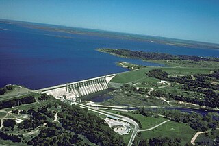
English: Aerial view of Whitney Lake and Dam on the Brazos River in Bosque and Hill Counties, Texas, USA. The river and lake form part of the border between the two counties. The U.S. Army Corps of Engineers constructed the dam in 1951 for flood control and water supply. View is to the north.
Coordinates: 31°51′59.45″N 97°22′15.64″W / 31.8665139°N 97.3710111°W |
|||
| مکان | Bosque and Hill Counties, Texas, USA | |||
| تاریخ | not specified or unknown | |||
| منبع |
U.S. Army Corps of Engineers Digital Visual Library Image page Image description page Digital Visual Library home page |
|||
| پدیدآور | U.S. Army Corps of Engineers, photographer not specified or unknown | |||
| اجازهنامه (استفادهٔ مجدد از این پرونده) |
|
تاریخچهٔ پرونده
روی تاریخ/زمانها کلیک کنید تا نسخهٔ مربوط به آن هنگام را ببینید.
| تاریخ/زمان | بندانگشتی | ابعاد | کاربر | توضیح | |
|---|---|---|---|---|---|
| کنونی | ۱۹ مهٔ ۲۰۰۷، ساعت ۰۱:۳۹ | | ۱٬۵۰۰ در ۱٬۰۰۰ (۲۳۴ کیلوبایت) | DanMS | {{Information | Description = {{en|Aerial view of Whitney Lake and Dam on the Brazos River in Bosque and Hill Counties, Texas, USA. The river and lake form part of the border between the two counties. The U.S. Army Corps of Engineers constructed the da |
کاربرد پرونده
صفحهٔ زیر از این تصویر استفاده میکند:
کاربرد سراسری پرونده
ویکیهای دیگر زیر از این پرونده استفاده میکنند:
- کاربرد در bo.wikipedia.org
- کاربرد در ceb.wikipedia.org
- کاربرد در da.wikipedia.org
- کاربرد در de.wikipedia.org
- کاربرد در en.wikipedia.org
- کاربرد در es.wikipedia.org
- کاربرد در fr.wikipedia.org
- کاربرد در ja.wikipedia.org
- کاربرد در no.wikipedia.org
- کاربرد در sv.wikipedia.org
- کاربرد در www.wikidata.org