
پرونده:Goreme National Park, Turkey.jpg

اندازهٔ این پیشنمایش: ۶۰۰ × ۶۰۰ پیکسل. کیفیتهای دیگر: ۲۴۰ × ۲۴۰ پیکسل | ۴۸۰ × ۴۸۰ پیکسل | ۷۶۸ × ۷۶۸ پیکسل | ۱٬۰۲۴ × ۱٬۰۲۴ پیکسل | ۲٬۴۰۰ × ۲٬۴۰۰ پیکسل.
پروندهٔ اصلی (۲٬۴۰۰ × ۲٬۴۰۰ پیکسل، اندازهٔ پرونده: ۲٫۷۷ مگابایت، نوع MIME پرونده: image/jpeg)
این پرونده در ویکیانبار موجود است. محتویات صفحهٔ توصیف آن در زیر نمایش داده میشود. |
خلاصه
| توضیح |
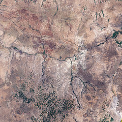
English: This is an image of Göreme National Park and its surroundings in Cappadocia, Turkey. A black outline delineates park boundaries.
|
| تاریخ | |
| منبع | NASA Earth Observatory |
| پدیدآور | Jesse Allen |
Image created using Landsat data provided by the United States Geological Survey. Instrument: Landsat 7 - ETM+
اجازهنامه
| این پرونده در مالکیت عمومی قرار دارد چرا که توسط ناسا ایجاد شده است. سیاست حق تکثیر ناسا بیان میکند که «مواد ناسا با حق تکثیر محافظت نمیشوند، مگراینکه ذکر شده باشد». (Template:PD-USGov، صفحهٔ سیاست حق تکثیر ناسا یا سیاست جیپیال استفاده از تصاویر را ببینید.) | ||
 |
هشدارها:
|
تاریخچهٔ پرونده
روی تاریخ/زمانها کلیک کنید تا نسخهٔ مربوط به آن هنگام را ببینید.
| تاریخ/زمان | بندانگشتی | ابعاد | کاربر | توضیح | |
|---|---|---|---|---|---|
| کنونی | ۷ ژوئن ۲۰۰۹، ساعت ۰۹:۵۳ | | ۲٬۴۰۰ در ۲٬۴۰۰ (۲٫۷۷ مگابایت) | Originalwana | {{Information |Description={{en|1=This is an image of Göreme National Park and its surroundings in Cappadocia. A black outline delineates park boundaries. Although the satellite’s perspective doesn't quite match the spectacular scenery from the ground, |
کاربرد پرونده
صفحهٔ زیر از این تصویر استفاده میکند:
کاربرد سراسری پرونده
ویکیهای دیگر زیر از این پرونده استفاده میکنند: