
پرونده:Gallia cisalpina - Shepherd png.png

پروندهٔ اصلی (۱٬۷۲۲ × ۸۸۲ پیکسل، اندازهٔ پرونده: ۳٫۶۴ مگابایت، نوع MIME پرونده: image/png)
این پرونده در ویکیانبار موجود است. محتویات صفحهٔ توصیف آن در زیر نمایش داده میشود. |
خلاصه
| توضیح |
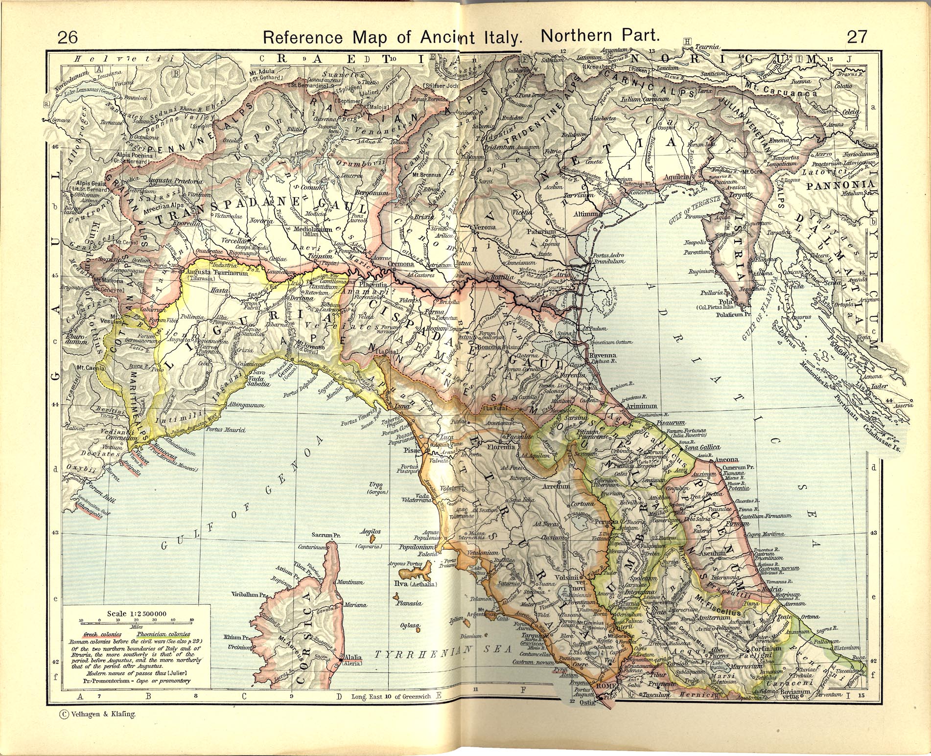
Italiano: Territori della Gallia cisalpina attorno agli inizi del I secolo a.C.
Historical Atlas by William R. Shepherd, 1911. Courtesy of the University of Texas Libraries, The University of Texas at Austin. From The Historical Atlas by William R. Shepherd, 1911 edition |
|||||
| تاریخ | ||||||
| منبع | File:Shepherd Map of Ancient Italy, Northern Part.jpg | |||||
| پدیدآور |
Historical Atlas by William R. Shepherd 1911 edition
Reference: Reference Map of Ancient Italy, Northern Part Courtesy of the University of Texas Libraries, The University of Texas at Austin. [1] |
|||||
| اجازهنامه (استفادهٔ مجدد از این پرونده) |
|
|||||

![[1]](http://www.lib.utexas.edu/maps/historical/shepherd/italy_ancient_south.jpg)
سیاهه بارگذاری اصلی
This image is a derivative work of the following images:File:Shepherd Map of Ancient Italy, Northern Part.jpg
10:05, 2007 July 1 user:Accurimbono . . (366 bytes) (+366) . . (== Summary == Map of South Italy during the Roman period. Extracted from The Historical Atlas by William R. Shepherd, 1911. Original image is at http://www.lib.utexas.edu/maps/historical/shepherd_1911/shepherd-c-026-027.jpg
این پروندهٔ رسانهای در ایالات متحده در مالکیت عمومی قرار دارد. این دربارهٔ آثار ایالات متحده که حقتکثیرشان باطل شده است صدق میکند؛ اغلب به این دلیل که اولین انتشارشان قبل از ۱ ژانویهٔ ۱۹۲۹ روی داده است. برای توضیحات بیشتر این صفحه را ببینید.
|
 | |
 |
ممکن است این نگاره در خارج از ایالات متحده در مالکیت عمومی نباشد؛ این مسئله بهخصوص دربارهٔ کشورها و مناطقی که قانون مدت کوتاهتر را برای آثار ایالات متحدهٔ آمریکا اعمال نمیکنند، همچون کانادا، چین (به جز هنگکنگ و ماکائو)، آلمان، مکیزیک، و سوئیس صدق میکند. آفریننده و سال انتشار اطلاعات ضروری هستند و باید ارائه شوند. برای جزئیات بیشتر، ویکیپدیا:مالکیت عمومی و ویکیپدیا:حق تکثیر را ببینید.
|
تاریخچهٔ پرونده
روی تاریخ/زمانها کلیک کنید تا نسخهٔ مربوط به آن هنگام را ببینید.
| تاریخ/زمان | بندانگشتی | ابعاد | کاربر | توضیح | |
|---|---|---|---|---|---|
| کنونی | ۹ نوامبر ۲۰۱۲، ساعت ۱۱:۳۲ | | ۱٬۷۲۲ در ۸۸۲ (۳٫۶۴ مگابایت) | Cristiano64 | Gallia Cisalpina included also (in I century BC): Liguria and Venetia |
| ۱۵ اکتبر ۲۰۱۲، ساعت ۰۷:۲۸ |  | ۱٬۷۲۲ در ۸۸۲ (۳٫۶۷ مگابایت) | Cristiano64 | User created page with UploadWizard |
کاربرد پرونده
صفحهٔ زیر از این تصویر استفاده میکند:
کاربرد سراسری پرونده
ویکیهای دیگر زیر از این پرونده استفاده میکنند:
- کاربرد در bg.wikipedia.org
- کاربرد در ca.wikipedia.org
- کاربرد در da.wikipedia.org
- کاربرد در en.wikipedia.org
- کاربرد در et.wikipedia.org
- کاربرد در fi.wikipedia.org
- کاربرد در fr.wikipedia.org
- کاربرد در hu.wikipedia.org
- کاربرد در it.wikipedia.org
- کاربرد در ja.wikipedia.org
- کاربرد در pt.wikipedia.org
- کاربرد در sh.wikipedia.org
- کاربرد در www.wikidata.org