
پرونده:Europa 1890.jpg

اندازهٔ این پیشنمایش: ۷۶۶ × ۵۹۹ پیکسل. کیفیتهای دیگر: ۳۰۷ × ۲۴۰ پیکسل | ۶۱۴ × ۴۸۰ پیکسل | ۹۸۲ × ۷۶۸ پیکسل | ۱٬۲۸۰ × ۱٬۰۰۱ پیکسل | ۲٬۵۰۰ × ۱٬۹۵۶ پیکسل.
پروندهٔ اصلی (۲٬۵۰۰ × ۱٬۹۵۶ پیکسل، اندازهٔ پرونده: ۱٫۸۴ مگابایت، نوع MIME پرونده: image/jpeg)
این پرونده در ویکیانبار موجود است. محتویات صفحهٔ توصیف آن در زیر نمایش داده میشود. |
خلاصه
| توضیحات |
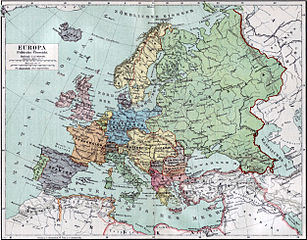
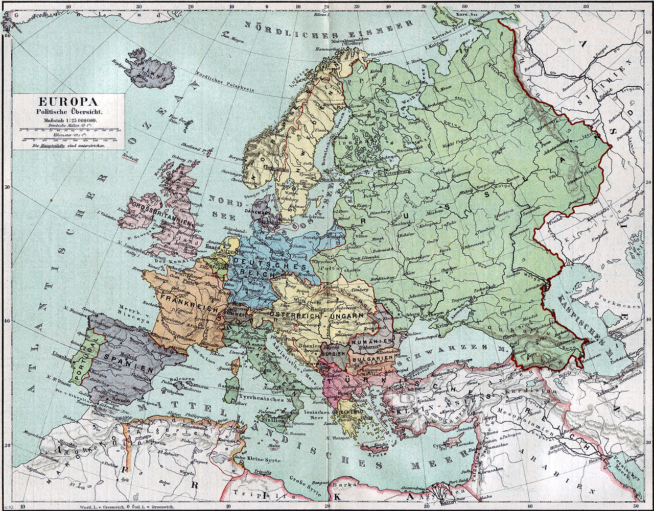
Politische Karte Europas ca. 1890 |
|||||
| تاریخ | ||||||
| منبع | Meyers Kleines Konversationslexikon. Fünfte, umgearbeitete und vermehrte Auflage. Bd. 1. Bibliographisches Institut, Leipzig und Wien 1892. | |||||
| پدیدآورنده |
unbekannt, scan by sidonius 15:36, 7 November 2006 (UTC) |
|||||
| اجازهنامه (استفادهٔ مجدد از این پرونده) |
|
|||||
| زمینمرجعسازی | اگر نامناسب بود لطفاً warp_status = skie را برای مخفیسازی تنظیم کنید. | |||||
| دیگر نسخهها | آثار انشقاقی از این پرونده: Blank map of Europe 1890.svg |

_en.png)
.png)
.jpg)
تاریخچهٔ پرونده
روی تاریخ/زمانها کلیک کنید تا نسخهٔ مربوط به آن هنگام را ببینید.
| تاریخ/زمان | بندانگشتی | ابعاد | کاربر | توضیح | |
|---|---|---|---|---|---|
| کنونی | ۷ نوامبر ۲۰۰۶، ساعت ۱۵:۳۶ | | ۲٬۵۰۰ در ۱٬۹۵۶ (۱٫۸۴ مگابایت) | Sidonius | {{Information |Description=Politische Karte Europas ca. 1890 |Source=Meyers Kleines Konversationslexikon. Fünfte, umgearbeitete und vermehrte Auflage. Bd. 1. Bibliographisches Institut, Leipzig und Wien 1892. |Date=1892 |Author=unbekannt, |
کاربرد پرونده
صفحهٔ زیر از این تصویر استفاده میکند:
کاربرد سراسری پرونده
ویکیهای دیگر زیر از این پرونده استفاده میکنند:
- کاربرد در bn.wikipedia.org
- کاربرد در de.wikipedia.org
- کاربرد در de.wikibooks.org
- کاربرد در en.wikipedia.org
- کاربرد در et.wikipedia.org
- کاربرد در fr.wikipedia.org
- کاربرد در hu.wikipedia.org
- کاربرد در it.wikipedia.org
- کاربرد در mk.wikipedia.org
- کاربرد در pl.wikipedia.org
- کاربرد در pnb.wikipedia.org
- کاربرد در sa.wikipedia.org
- کاربرد در scn.wikipedia.org
- کاربرد در skr.wikipedia.org
- کاربرد در uk.wikipedia.org
- کاربرد در ur.wikipedia.org