
پرونده:Debris-GEO1280.jpg

پروندهٔ اصلی (۱٬۲۸۰ × ۱٬۰۲۴ پیکسل، اندازهٔ پرونده: ۱۲۵ کیلوبایت، نوع MIME پرونده: image/jpeg)
این پرونده در ویکیانبار موجود است. محتویات صفحهٔ توصیف آن در زیر نمایش داده میشود. |
| توضیح |
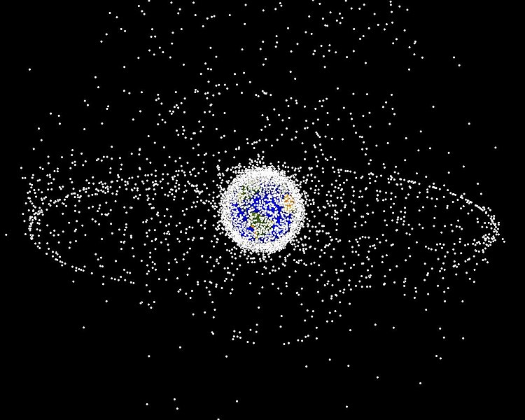
English: Debris plot by NASA.
A computer-generated image of objects in Earth orbit that are currently being tracked. Approximately 95% of the objects in this illustration are orbital debris, i.e., not functional satellites. The dots represent the current location of each item. The orbital debris dots are scaled according to the image size of the graphic to optimize their visibility and are not scaled to Earth. The image provides a good visualization of where the greatest orbital debris populations exist. This image is generated from a distant oblique vantage point to provide a good view of the object population in the geosynchronous region (around 35,785 km altitude). Note the larger population of objects over the northern hemisphere is due mostly to Russian objects in high-inclination, high-eccentricity orbits. |
|||||
| منبع | NASA Orbital Debris Program Office, photo gallery | |||||
| پدیدآور | NASA image | |||||
| اجازهنامه (استفادهٔ مجدد از این پرونده) |
|


تاریخچهٔ پرونده
روی تاریخ/زمانها کلیک کنید تا نسخهٔ مربوط به آن هنگام را ببینید.
| تاریخ/زمان | بندانگشتی | ابعاد | کاربر | توضیح | |
|---|---|---|---|---|---|
| کنونی | ۱ فوریهٔ ۲۰۰۵، ساعت ۱۶:۴۵ | | ۱٬۲۸۰ در ۱٬۰۲۴ (۱۲۵ کیلوبایت) | Srbauer | debris plot by NASA |
کاربرد پرونده
صفحهٔ زیر از این تصویر استفاده میکند:
کاربرد سراسری پرونده
ویکیهای دیگر زیر از این پرونده استفاده میکنند:
- کاربرد در af.wikipedia.org
- کاربرد در an.wikipedia.org
- کاربرد در ar.wikipedia.org
- کاربرد در az.wikipedia.org
- کاربرد در be-tarask.wikipedia.org
- کاربرد در be.wikipedia.org
- کاربرد در bn.wikipedia.org
- کاربرد در ca.wikipedia.org
- کاربرد در cs.wikipedia.org
- کاربرد در da.wikipedia.org
- کاربرد در de.wikipedia.org
- کاربرد در de.wiktionary.org
- کاربرد در el.wikipedia.org
- کاربرد در en.wikipedia.org
- Earth
- International Space Station
- Geosynchronous orbit
- Geostationary orbit
- Envisat
- Outer space
- Talk:Geostationary orbit
- Planetes
- Kessler syndrome
- Portal:Outer space
- Spacecraft cemetery
- Catcher's Mitt
- Human presence in space
- User talk:Penyulap/staticEnglish
- Space Surveillance Telescope
- User:Ginnybarnes/Spacecraft cemetery
- Portal:World
- User:FreshYoMama/TWA/Earth
- User:FreshYoMama/TWA/Earth/2
- User:Mumuhuohuo
- Draft:Space Congestion
- کاربرد در en.wikinews.org
- کاربرد در eo.wikipedia.org
- کاربرد در es.wikipedia.org
نمایش استفادههای سراسری از این پرونده.